Albers Equal-Area Conic Projection
In the Albers Equal Area Conic, USA is made to be at the centre of the globe and highlighted as a section. The section is enclosed with +20 – +56 degree latitude and -60 to -135 longitude. A cone would be projected over the arctic region. It will pass through the globe and further touch at two parallels known as the secant. In this projection, the parallels are not distorted and the horizontals remain the same. The geometric properties that are distorted are the length.
Mercator Projection
The Mercator projection is cylindrical in nature and is widely used in navigation across the seas. It represents the lines of constant course as straight segments. It uses a linear scale and this has a constant size in all directions. Smaller objects and landmasses are not distorted and their shapes and angles are preserved. Larger objects are distorted and the shape and angles of larger landmasses are distorted. This occurs because the scale of the map would be increasing as one goes from the equator to the arctic region.
Plate Carree Projection
The plate carree projection maps the meridians of the globe to vertical lines that are straight and vertical. In this projection, the latitude circles are spaced in equal horizontal lines. The projection thus formed is not conformal and it is also not equal area. Distortions would be observed in the projection of the globes and farther landmasses from the map centre.
Among the three map projections, the best map projection for navigation is the Mercator. is the Mercator since it does not distort smaller landmasses and the scale representation is true even when the curved globe is projected on a flat face.
Geographic Coordinate System – GCS
Geographic Coordinate System is a type of coordinate system that allows all locations on the globe to be identified by using spherical coordinate systems. Our earth is not an exact sphere but a rough ellipsoid. GCS is specified by the latitude and the longitude. Latitude is the angle extended from a point on the earths surface to the plane of the equator. It is measured from the centre of the sphere. Longitude is the angle to the west or east of a reference median that is placed between the two poles.
The Geographic Coordinates of the “City University of New York Hunter College” is Latitude: 40° 46′ 06″ N, Longitude: 07° 35’52” W.
Conversion to DMS
40 46 06N in DMS
06/60 = 0.1
46+0.1=46.1/60 = 0.768333
N404606.768333
0735752W in DMS
52/60 = 0.866
57+0.866 = 57.866/60 = 0.964433
W0735752.964433
Universal Transverse Mercator
The UTM – Universal Transverse Mercator coordinate system divides the Earth’s surface into flat grids. Each of the grids is identified by zone numbers. This zone number range from 01 through 60, east to west and each of them is 6 degrees wide. There are also zone designators C through X, south to north. A central meridian is provided in each of these zones and coordinate of a place is given with reference to the central meridian.
The nomenclature is ‘northing’s’ that stands for meters north of the equator. To specify the eastern coordinate, it is expressed as ‘easting’s’ and this stands for east of the central meridian for the zone. There is one system of coordinates and this is the NAD83. It is an acronym for “North American Datum of 1983”. The NAD83 is used as the base for measurements of any point in the direction of x, y and z coordinates. NAD83 differs from NAD27 as NAD makes use of a different ellipsoid with much more improved accuracy.]
UTM Coordinates
The UTM coordinates (NAD83) of my hometown are (NGS, 2002)):
Easting: 587373.855 meters, Northing: 4513579.578 meters, Zone: 18

The Universal Transverse Mercator Coordinate – UTM system gives the coordinates on a worldwide flat grid for easy computation. In this system, the globe is split into sixty zones. Each zone would cover six degrees of the longitude. It goes from 80 degrees south latitude to 84 degrees from the northern latitude. In this system, the arctic and the Antarctic polar regions are not included. The first zone starts at the International Date Line (longitude 180 degrees) proceeding eastward
State Plane Coordinates
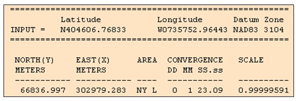
The State Plane coordinates (NAD83) of my home town are (NGS, (2002).
Easting: 302979.283 meters, Northing: 66836.997 meters, Zone: NY L

The State Plane Coordinate system give the coordinates on a flat grid for easy computation. It also allows one to maintain a difference between geodetic and grid distance of one part in 10,000 or better. The State Plane Coordinate system divides the U.S. into a hundred or more distinct grid surfaces (Zones). State Plane Coordinates System was invented in the 1930s and it uses Cartesian coordinates (x,y) instead of geographic coordinates (lat, long). There are 124 SPC zones, each is mapped individually with its own projection to minimize distortion. Zones that are long E-W are usually projected in Lambert conformal conic and those that are long N-S are usually projected in Transverse Mercator.
References
Baxter, Ryan (2006) Interactive Album of Map Projections.
NGS, (2002). National Geodetic Survey SPC Utilities.
USGS, (2002) United States Geological Survey: Geographic Names Information System.