Singapore
Singapore is a small city-state country located in Southeast Asia. The absolute location of Singapore is comprised of its longitude and latitude, at it constitutes the longitude of 1.290270 North and latitude of 103.851959 East (“Singapore, the Republic of Singapore,” n.d.). The country’s absolute location is near the equator, which affects the state’s climate. When speaking of the relative location of Singapore, the state is located near Indonesia and Malaysia. The country is the smallest state in Southeast Asia, and it is a state comprised of a single city located on sixty-four different islands. Singapore is approximately 2,580 mi away from New Delhi, India, and 9,500 mi away from the US.
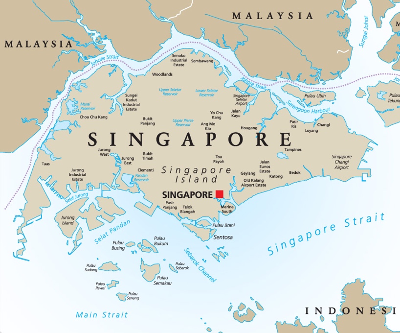
Since Singapore is regarded as a city-state, the majority of its territory is urban. The area of the country is 280 square miles, which makes it the second-smallest country in Asia after the Maldives. Since Singapore is an island, it is surrounded by water entirely. Thus, in the south, Singapore is bordered by Singapore Strait, Selat Jurong, Selat Pandan, and Sebarok Channel. In the north, the state is bordered by Johore Strait. More water reservoirs can be seen on the geography map below:
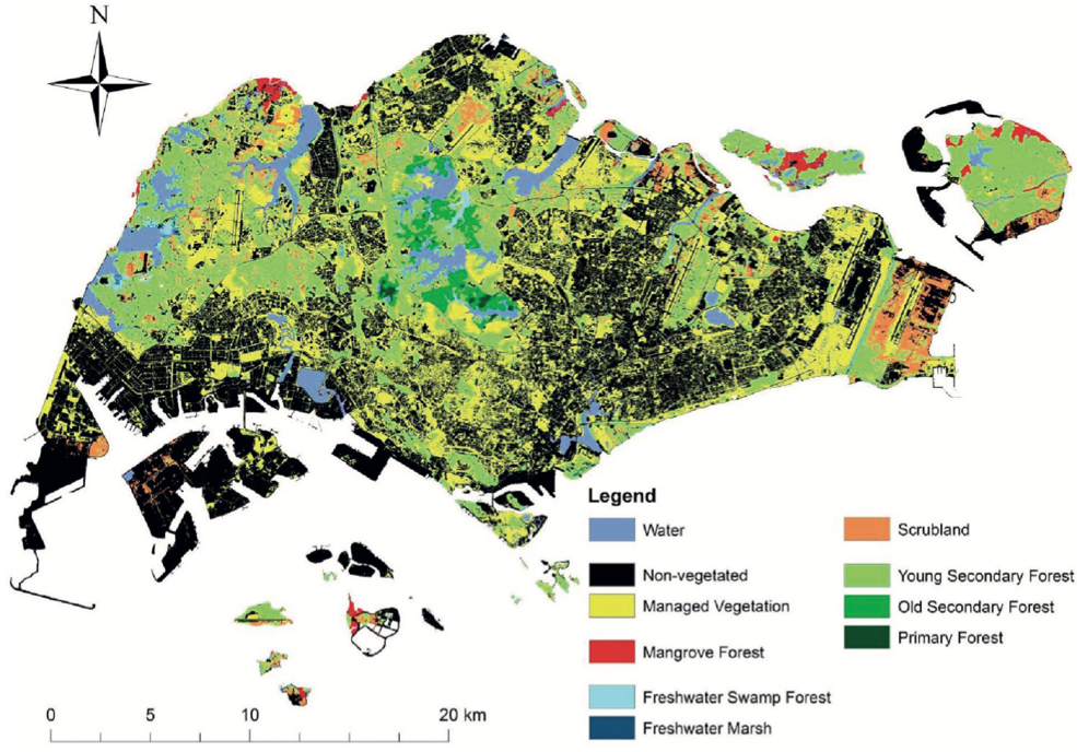
The state of Singapore has many forests, and the “green” zones of the country are seen on the map below:
Singapore is a relatively flat island, and the highest hill in the country is approximately 160m high. Hence, there are many beneficial aspects of Singapore as a place, and it may serve as an asset for potential international collaboration. As far as the socio-cultural aspects of the country are concerned, the population of Singapore constitutes nearly 5.7 million people (World Bank, 2020). The most spoken languages are Mandarin and English, and the most widespread religion is Buddhism. The Singapore community is a highly diverse region due to the fact that over the past centuries, its colonization has brought a series of different cultural impacts on the population and development of a nation.
As far as the notion of movement is concerned, it is necessary to account for both physical and non-physical movement. The latter, primarily tackling the notions of transferring ideas and concepts, encompasses WWW, radio, television, and telephone. The physical movement, including the transfer of goods and people, happens with the help of aircraft, railway, cars, bikes, public transportation, including buses, taxis. Although Singapore does not have underground transportation due to a high risk of underground waters damaging the network, the city of Singapore, more specifically, the largest island of Singapore, has a so-called Mass Transit System (MTS) that functions similarly to a subway network in the US, but on the surface (“Getting around Singapore,” n.d.). Hence, it may be concluded that the theme of movement in Singapore is defined similarly to the rest of the world.
The central resources of Singapore are fish and various kinds of manufacturing. Currently, a high focus on the manufacturing industry leads to low sustainability levels within the country. Although the pollution index of Singapore decreased in 2020, the pollution index is still high (“Pollution index by country: Singapore,” 2021). The majority of pollutants, for their part, are produced by refineries and other industries (National Environment Agency, n.d.). Air pollution also deteriorates because of the high density of the population. Currently, people, major contributors to pollution and deforestation of the land, allocate resources to the development of less hazardous means of production in order to preserve and revive the natural resources. Hence, the human-environment interaction in Singapore is rather neutral, as people tend to both destroy and preserve some of the resources.
Finally, as far as the regions are concerned, Singapore is divided into five major regions:
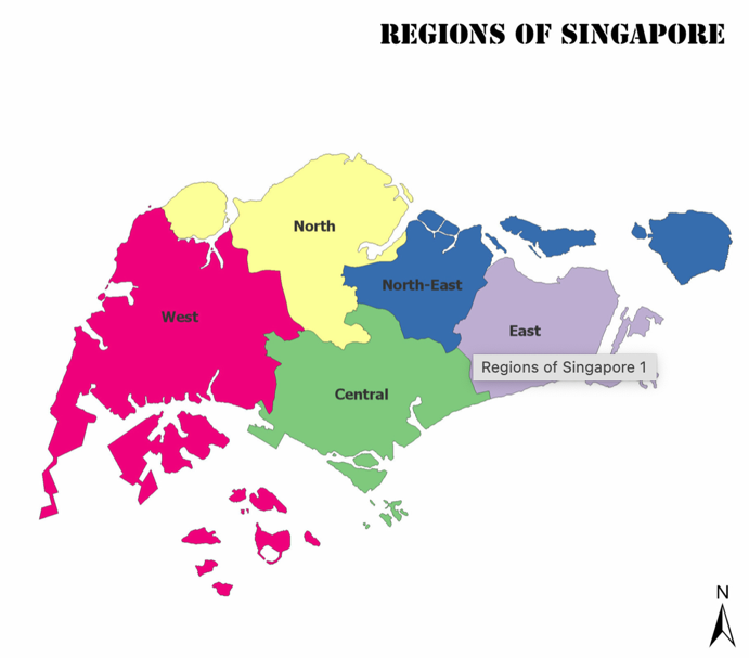
The Central region of the country is associated with business centers and various cultural landmarks. The North region is characterized by a lower density of population and more luxurious living conditions. The rest of the regions are densely populated areas for the majority of Singapore’s population.
Philippines
The Philippines is a country situated in Southeast Asia. The absolute location of the country has a longitude of 12.87 degrees North and 121.77 degrees East (“Philippines latitude and longitude map,” n.d.). The relative location of the country may be characterized by its location directly east of Vietnam and northeast of Malaysia. The country is an archipelago and, thus, has no land borders with the states. The maritime borders, however, include Taiwan, Japan, Palau, Indonesia, Malaysia, Brunei, and Vietnam. The Philippines is approximately 2,800 mi away from India and 8,200 mi away from the US. The country is located next to such water reservoirs as the South China Sea, the Philippine Sea, and the Celebes Sea.
The movement patterns within the state are similar to the ones widespread around the world. The physical movement items include aircraft, roads, railways, buses, cars, and public transportation. There are several types of transport unique to the region, and they include tricycles, jeepneys, and multi-cabs. The non-physical patterns of movement include the Internet, television, radio, and phone connection, so the country is by no means isolated from the rest of the world. As far as the goods that are exported are concerned, some of the most widespread products include copper strings and computers. These goods are usually transported by boats and other marine vehicles. Hence, the movement in the Philippines, although sometimes less modern, remains relevant to the rest of the world.
The Philippines as a place has a variety of distinct cultural and physical aspects. To begin with, the Philippines is an archipelago that, at some point, broke out from Pangaea. It consists of nearly 7,000 small islands that were isolated by water as a result of tectonic processes and volcano eruptions. Previous volcano eruptions, for their part, contributed to the creation of a diverse relief of the country. Thus, the highest mountain in the Philippines, Mount Apo, which constitutes almost 3,000 m, is nothing but a dormant stratovolcano that is considered active to date (“Mount Apo,” n.d.). Currently, there are nearly 300 volcanoes in the country, 22 of which are officially considered active (Philippines Institute of Volcanology and Seismology, 2018). The Philippines is famous for its diverse fauna, with new animal species found and recorded every year. When speaking of socio-cultural patterns, the population of the Philippines is approximately 109.5 million people (World Bank, 2020). Unlike the vast majority of Asian countries, the Philippines is an overwhelmingly Christian state. The Philippines is a highly diverse geographic region, as it serves as a home for more than a hundred ethnolinguistic groups.
The country’s primary asset in terms of natural resources is the number of metallic minerals found in the volcanic plates of the region. Thus, the majority of people are highly dependent on the extraction of such minerals as gold, silver, copper, iron ore, and lead. Hence, humans benefit significantly from the resources stored in the region. At the same time, the national population struggles significantly with the frequent volcano eruptions and other natural disasters that destroy their habitat. The socio-economic instability of the region leads to high levels of air pollution, people do not have the ability to allocate resources to the development of sustainable practices (Sabillo, 2020). Hence, the human-environment interaction is not exactly beneficial in the area.
When speaking of the region, the ethnocultural diversity of the country does not stand in the way of a powerful sense of community and unitedness. For many years, the notion of culture has become a significant tool for the Philippine population due to the need to refer to some spiritual and ethnic practices during natural disasters in order not to lose morale. Thus, there are many manifestations of Philippine culture, including national clothing and food, such as pancit.
Thailand
Thailand is a state situated in Southeast Asia. The absolute location of the country has a longitude of 13.750 degrees North and 100.483 degrees East (“Thailand latitude and longitude map,” n.d.). The relative location of the country may be characterized by its land borders with Laos, Myanmar, Cambodia, and Malaysia:
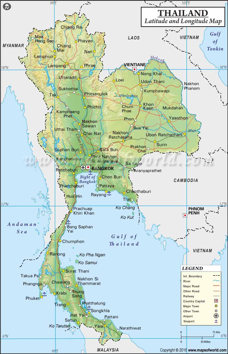
The country is approximately 2,500 mi away from India and 7,500 mi away from the US. Since it has a land border with many countries and is only bordered by water in the south, its geographical location is quite beneficial.
The physical movement patterns in Thailand are highly similar to the ones in the rest of the countries. Usually, people move with the help of buses, taxis, bicycles, and motorbikes. There is a national railway network that facilitates the movement within the state. There is also an established airline movement pattern established between Bangkok and other states. Apart from the conventional movement means, Thailand’s most popular form of intranational transportation is a tuk-tuk, which is a popular vehicle in Asia. The movement of ideas takes place with the help of the Internet, television, radio, and written communication.
Thailand is a beautiful and diverse land with a rich culture and flora, and fauna life. Thailand covers nearly 500 thousand square kilometers, and it is bordered by the Gulf of Thailand in the south of the country. There are not many mountains in the area except for the northern regions, with the highest mountain, Doi Inthanon, constituting nearly 2,500 m. Apart from these highlands, the rest of the country is relatively flat. The tropical climate of Thailand contributes to the existing variety of flora and fauna across the state. Hence, Thailand as a place is an extremely beneficial tourist attraction.
Fishing and agriculture activities are some of the country’s most popular activities among the population. However, a lack of proper regulation to facilitate anthropological activity leads to high rates of deforestation, illegal hunting, and flora and fauna exploitation. The high density of the population also leads to the inevitable air pollution caused by extensive use of transport and cheap manufacturing patterns. The latter also contributes to large amounts of the factory and organic waste in the water. Hence, it becomes evident that, currently, human interaction with the environment is rather detrimental.
Thailand is comprised of three major regions: northern, southern, and central. The central region is rightfully one of the liveliest parts of the country that is characterized by a high concentration of tourists, ethnic diversity, higher population density, more employment centers, and cultural attractions. Southern Thailand is also popular with tourists due to its location on the coast of the Gulf of Thailand. Fishing is one of the prominent sources of income for the region. The northern area is less attractive for the tourists because it is comprised largely of the Phetchabun mountain range. Nevertheless, it is also a place with various cultural and historical landmarks.
Cambodia
Cambodia is a county located in Southeast Asia, more specifically, the Indochinese peninsula. In terms of the absolute location, the country has a latitude of 11.5500 degrees north and a longitude of 104.9167 degrees east (“Cambodia latitude and longitude map,” n.d.). When speaking of relative location, Cambodia borders Laos, Thailand, and Vietnam. The southwest of the country is bordered by the Gulf of Thailand:
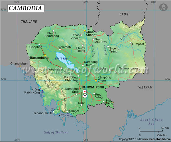
Cambodia is approximately 2,900 mi away from India and 8,700 mi away from the US. Hence, the location of Cambodia may be considered beneficial.
Some of the most widespread means of physical movement for Cambodian residents include bicycles, motorcycles, and, sometimes, taxis, The use of cars is not as widespread as in developed countries due to the poor quality of roads in the country. Thus, cars are mostly used to travel internationally. Cambodia currently has a few registered airlines and a railway network, so the primary issue with transpiration is the road quality in the country. The ideas move with the help of technology, including the Internet, phone, television, and radio. Hence, it may be concluded that as of today, the movement patterns in Cambodia, although rapidly developing, are still behind the majority of other states.
As far as the place is concerned, Cambodia is a beautiful country with rich flora, river network, and cultural heritage landmarks. Some of the most significant Cambodian rivers include Mekong, Stoung, Stung Sen, and Tonle Sekong. They serve as the main sources of water and fish, so the population is denser in the river areas. The vast relief of the country is flat, but there are several mountains, including Cardamon and Elephant mountains, with the former being approximately 1,800 m high. As far as the cultural aspects are concerned, the monument of Angkor Wat is one of the most impressive temples not only in Cambodia but in the whole world. The temple is Buddhist, just like the majority of the population in Cambodia (UNESCO World Heritage Convention, n.d.). There are also many other cultural manifestations in Cambodia, including dances and festivals.
Currently, the patterns of human-environment interaction are rather complicated in Cambodia, as the levels of economy and social growth within the state are insufficient to secure sustainable manufacturing and agriculture. The latter serves as the most important source of income for the population and the country in general. For example, textile goods, being the most popular goods for export, require land to raise cultures like cotton and flax. To find this land, local residents tend to destroy forests for agricultural purposes. The levels of air pollution due to cheap and unsustainable export-oriented manufacturing are also quite high.
Cambodia is primarily divided into the southern and northern regions. Similar to Thailand, Cambodia’s southern region is focused on fishing and coastal patterns of lifestyle. The northern regions, on the other hand, are more preoccupied with agriculture. The ethnolinguistic diversity of the northern region is higher due to the fact that in the highland region, there are various isolated tribes and populations that live quiet and solitary life.
Vietnam
Vietnam, or the Socialist Republic of Vietnam, is a country located in Southeast Asia. In terms of the absolute location, Vietnam has a latitude of 13 degrees north and a longitude of 106 degrees east. While the vast of the country’s east is bordered by the water reservoirs, Vietnam’s western and northern borders intersect with Laos, China, and Cambodia:
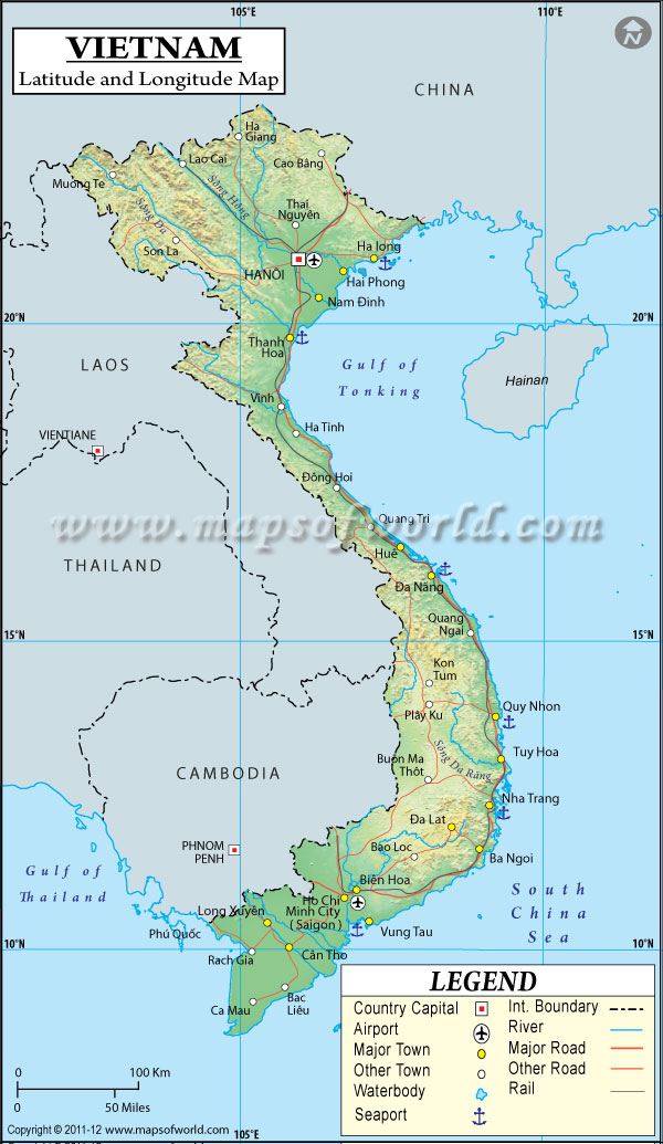
The country is approximately 8,500 mi away from the US and 3,200 mi away from India. Hence, the location of Vietnam is extremely beneficial both due to the border with China and an extensive coastline.
The movement patterns in the state are similar to the rest of the world. Thus, people tend to move by cars, trains, taxis, and public transport within the country while utilizing airplanes, buses, and ferries to travel long distances and supply goods. The information and ideas mostly travel through the Internet, television, and phones. However, the issue with Vietnam is the fact that a one-party pro-communist political system tends to filter the information accessed by the population, so the movement of ideas is possible yet not liberal.
Vietnam occupies approximately 330,000 square kilometers, which is similar to Japan’s area. The country is bordered by the Pacific Ocean, the Gulf of Thailand, and the Gulf of Tonkin, which provides some beneficial international trade opportunities. The country’s terrain has both highlands and lowlands. Fansipan is the highest mountain in Vietnam, constituting more than 3,000 m in height. Fansipan is a part of the country’s mountainous area. Vietnam is a culturally diverse country, with the majority of ethnic minorities settled in the mountains. The concept of cultural heritage and, specifically, religion is a highly complex endeavor in Vietnam, as it is officially a communist state.
As far as the human-environment interactions are concerned, the country that is focused on agriculture and manufacture of export has some serious issues as a result of human activity. Currently, Vietnam is considered to be one of the most polluted states in the Western Pacific (Quy, 2021). While these results were catalyzed by anthropological activity and people became preoccupied with the mortality rates associated with pollution, nearly 15% of the population still do not think about ways to help the environment (Quy, 2021). Indeed, a considerable number of factories that deal with export items are not preoccupied with pollution for the sole reason of keeping their profits, as there are developed countries that exploit developing nations in terms of trade and exporting goods, and the Vietnamese population is scared of losing employers.
Finally, as far as the regions are concerned, there are Central Highlands, Central Lowlands, Mekong and Red River Deltas, and Mountainous land. The regions are divided on the basis of the terrain specifics, as they are highly correlated with the type of human activities performed in the areas. Thus, for example, while mountainous lands are mostly inhabited by ethnic minorities, river deltas are characterized by access to the water and people’s focus on aquaculture.
References
Cambodia latitude and longitude map. (n.d.). Web.
Getting around Singapore. (2021). VisitSingapore. Web.
Mount Apo. (n.d.). Provincial government of Davao del Sur. Web.
National Environmental Agency. (n.d.). Air pollution. Web.
Philippines Institute of Volcanology and Seismology. (2018). Volcanoes of the Philippines. Web.
Philippines latitude and longitude map. (n.d.). Web.
Pollution index by country. (2021). Knoema. Web.
Population, total – Philippines. (2020). World Bank. Web.
Quy, N. (2021). Air pollution top environmental concern among Vietnamese citizens. Web.
Regions of Singapore. (n.d.). Mappr. Web.
Sabillo, K. (2020). Beyond lockdown: Can the Philippines sustain low air-pollution levels? Earth Journalism Network. Web.
Singapore – geography and maps. (n.d.). GoWay. Web.
Singapore, the Republic of Singapore. (n.d.). LatLong. Web.
Thailand latitude and longitude map. (n.d.). Web.
UNESCO World Heritage Convention. (n.d.). Angkor. Web.
Vietnam latitude and longitude map. (n.d.). Web.
World Bank. (2020). Singapore. Web.
Yee, A. T. K., Chong, K. Y., Seah, W. W., Lua, H. K., & Yang, S. (2019). Vegetation of Singapore. Flora of Singapore, 1, 47-70.