Map comparison
The present day state of China is a consequence of spatial-expansion that traces back to an era long before Christ (1900 BC). Basically, until early twentieth century China was synonymous with dynastic rule.
With Manchu dynastic rule (1644-1991) recording massive gains and thus hitting an all-time high, the entire period represents rollercoaster kind of gains.
However, a blanket analysis on the entire period reveals gradual gains from the core area of Xia, extending to the present day Mongolia, Tibet, Myanmar, Turkestan, Indochina, Korea and Taiwan. Nevertheless, an anticlimax and hence the end of the final dynasty coincided with European and Japanese invasion (Schaefer 230).
China’s spatial expansion is comparable to other forms of expansions including Islam, South American cultures, United States settlement and the Russian empire in the sense that they all emanate from a core region extending outwards where their influences decimate. However, while all the rest are foreign based China’s spatial expansion originates from the natives.
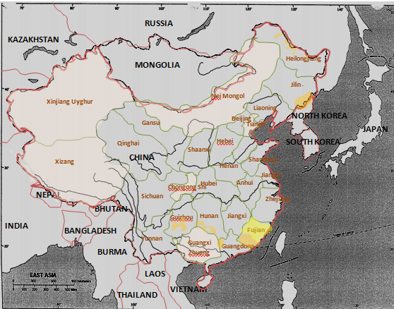
Chinese state experiences imbalanced forces originating from ethnic diversities that portray irregular population density patterns. As such, the administrative units are designed in a way to cater for the ethnic minorities who include the non-Han speaking population. Consequently, the laws of the day apply selectively depending on the region.
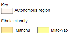
The regions reserved for the ethnic minorities are the ‘Autonomous regions (AR)’ and, have specific laws that don’t apply to other regions. Large expands of land covering the northern and western parts of China represent these regions. However, the population pressure from the majority Han Chinese tends to defy these efforts hence; the ARs are currently dominated by Han Chinese (MacLeod and Jones 671).
Japan is a state that constitutes four Islands including Kyushu, Shikoku, Honshu and Hokkaido. Of the four islands Honshu forms the foci of Japan’s core area and, it is a manufacturing center cum human settlement zone. Importantly, Japan’s core area is located at the center of three tectonic plates and as such, most of the area is mountainous and prone to earthquake.
In effect, with an ever burgeoning population (currently at 127 million) coupled with limited space, majority of the population (78%) resides in the urban centers that are located at the coastal cities. While some industries rest on reclaimed land from the sea thanks to the challenges posed by the land, agricultural land is being encroached by the ever growing population.
Japan’s economic zone is located on its core area- Honshu. There are two major economic zones in Japan including Kanto plain and Kansai district. The former ranks first with its focus centered in Tokyo as its urban center.
It has a fine harbor (Yokohama) and a fairly flat terrain hosting majority industries. However, it is prone to earthquake. On the other hand, Kansai district which ranks second constitutes Osaka-Kobe-Kyoto triangle port. This zone has its focus in Nagoya city which rests on Nobi plain and, is anchored by Kitakyushu conurbation on the west.
Being part of Jakota triangle, South Korea and Taiwan represent vital members of the world economy: economic tigers. These two states are similar with regard to agricultural land use, transportation and urbanization. With regards to agricultural land use the terrain of both states are unfavorable for agriculture.
Consequently, the states have resorted to manufacturing industries which forms the backbone of their economies. While Taiwan enjoys world’s market share in computers and electronics, South Korea boasts unprecedented world’s market share in shipbuilding.
Consequently, the economies of these states have been to new heights encouraging urbanization as the limited agricultural lands remain underutilized (Kimble 500). The states’ main means of transport is by railroads. However, South Korea’s rail transport is more intensive than its counterpart. Moreover, Taiwan has negligible agricultural land relative to South Korea’s.
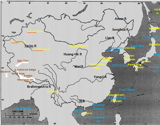
Map 1: East Asian Physical geography map.

Map 2: political-cultural information.


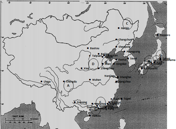
Map 3: urban-economic information

Key:
A– Red Basin B-North China Plain C-Liao-Songhua Lowland D-Loess Plateau E-Pearl River Estuary F-Shenzhen Special Economic Zone G-Kanto Plain H-Kansai District I-Nobi Plain J-Kitakyushu
Multiple-Choice:
1. (d)
2. (a)
3. (b)
4. (b)
Work Cited
Kimble, Hebert. “The Inadequacy of the Regional Concept” London Essays in Geography 2.17 (1951): 492-511. Print.
MacLeod, George, and Jones Mother. “Renewing The Geography of Regions.” Environment and Planning 16.9 (2001): 669-800. Print.
Schaefer, Frankline. “Exceptionalism in Geography: A Methodological Examination.” Annals of the Association of American Geographers 43.3 (1953): 226-245. Print.