Introduction
GPS is a Global Positioning System built on satellite knowledge. The U.S. Department of Defence was the initiator of this technology in 1970s. Originally, GPS was functional in the military department; however, later it served both the public and the military. GPS gives nonstop location and timing details, any place in the globe under any climatic conditions.
Many people all over the world use GPS, therefore it has to be a passive system for safety purposes. Specifically, the users can only get the satellite information (El-Rabbany, 2002).
The basic function of GPS is to calculate the area of effective operation between the receiver and users’ satellites. The locations of the satellites are calculated and transmitted together with the GPS signal to the user.
Through many identified locations of the satellites and the calculated distances between the receiver and the satellites, the location of the receiver is determinable. The location change, which is also determinable, is the velocity of the receiver. The most significant uses of GPS are locating and navigating (Xu, 2007).
Basic Concepts of GPS
The concept behind GPS is rather straightforward. If the space from a GPS receiver to three GPS satellites is determinable along with the satellite positions, then the idea of resection can determine the location of a point.
Each GPS satellite broadcast a microwave radio signal that has two transmitters, two codes, and navigation information. The GPS receives data from the GPS data through the antenna; it then computes it through receiver software. The result of this computation consists of the lengths to the GPS satellites through the numerical codes and the satellite locations through the navigation information.
Hypothetically, only three lengths to three concurrently traced satellites are required. The position of the receiver is between the intersections of three spheres. Practically, however, a fourth satellite is required for the receiver clock balance (El-Rabbany, 2002).
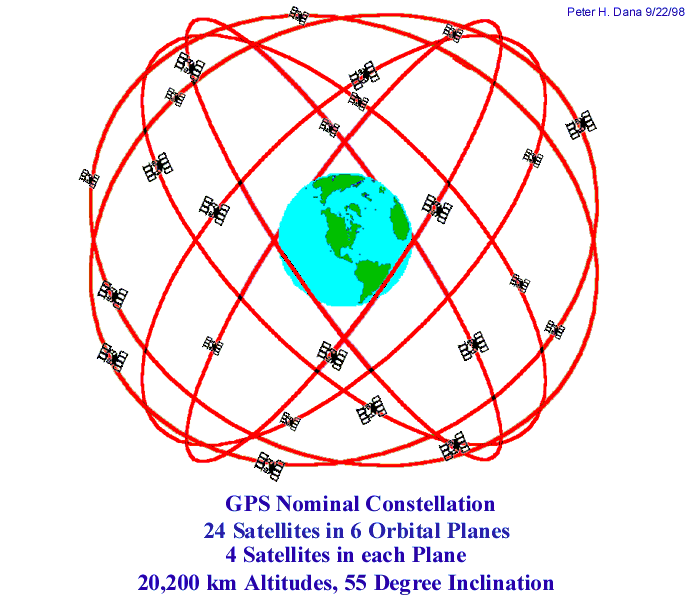
The GPS assemblage comprise of twenty-four satellites in six orbital surfaces, each surface holding four satellites. The space between the nodes of the orbital surface is symmetrical and differs by 60 degrees. The orbital surfaces slant at 55 degrees. Each GPS satellite is in a spherical trajectory with a minor axis of 26578 km in a day.
The satellites adjust themselves regularly so that their solar panels face the sun, and their antennas face the earth. Every satellite contains four atomic timers, proportional to the size of a car. The purpose of the timers is to give the L-band frequency (Xu, 2007).
Moreover, there are base stations that supervise the GPS satellites. These stations have cesium timers and receivers to establish the transmission ephemerides and to adjust the satellite timers. The satellites receive these adjustments and ephemerides and transmit them to GPS receivers (Tsui, 2005).
The paths of GPS are accessible by transmission or the International Geodetic Service (IGS). IGS trajectories are defined ephemerides after the operation. All GPS receivers possess an almanac set in their system, which gives the location of each satellite. The almanac is an information record that has details of trajectories and timings of all satellites.
The GPS receivers identify, interpret, and process the signals got from the satellites. The programs of the receiver process the real time data and produce the data to the user. Because of the inadequacy of the receiver programs, an external computer does accurate locating and navigating using stronger programs.
GPS segments
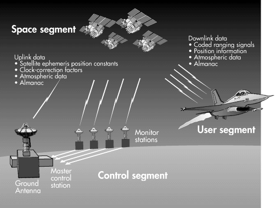
GPS comprise of three divisions: space, control, and user sections. The space section comprise of a 24-satellite collection. Each GPS satellite sends a signal, which has a number of elements: two transmitter frequencies, two digital codes, and a navigation data. The codes and the navigation data pass as binary bi-phase modulation.
The navigation data includes the location of the satellites as a variable of time. Atomic timers in the satellites direct the broadcast signals (Xu, 2007).
The control section of the GPS has a global network of tracing stations, with the main control station being in USA, Colorado. The function of the control section is tracing the GPS satellites to know and calculate satellite locations and other conditions. The GPS satellite through the S-band link then collects all data. The user section covers all military and public users. By using a GPS receiver, a user can get the GPS signal, which can show his or her position any place in the globe (El-Rabbany, 2002).

Figure 1: GPS segments (Source: El-Rabbany 2002, p.3)
GPS satellite generations
GPS satellite constellation began with a group of eleven satellites known as Block I satellites. These satellites are useful in experiments. The gradient angle in relation to the equator was 63°. Though Block I satellites were created to last for four and half years, some have extended their lifetime to ten years.
Block II/IIA, is the second generation of GPS satellites. Block IIA is an improvement of Block II, and it has advanced in its storage capacity from two weeks to six months.
This implies that Block IIA can work accurately without base support during this period. Block II/IIA has a gradient of 55° in relation to the equator, which differ from that of Block I. Block II/IIA have are formed to last for seven and a half years. For safety measures, some aspects such as selective ability and antispoofing were included in Block II/IIA (Xu, 2007).
The latest generation of GPS satellites is Block IIR. It has twenty-one satellites with a life span of ten years. Apart from having a high precision in its measurements, Block IIR has the capacity to function for at least six months without base support. In addition, common satellite capacities, has enhanced its independent routing capacity.
Finally, Block IIF is another GPS system that has thirty-three satellites. This system has the capacity to last fifteen years. Block IIF satellites have new potential under the GPS modernization strategy that will enhance GPS locating precision (El-Rabbany, 2002).

Figure 2: GPS constellation
GPS positioning service
To keep the lead in GPS use, the US Department of Defence has formed two phases of GPS positioning services: the Precise Positioning Service (PPS) and the Standard Positioning Service. PPS is the most accurate independent positioning service. It applies GPS codes known as P(Y)-code available to certified personnel.
The users are from the military department.SPS, however, is less accurate than PPS. It applies a C/A code, which is accessible to all civilians. At first, SPS gave precise measurements due to selective availability. However, with recent advancements in SPS, its precision is similar to the PPS (El-Rabbany, 2002).
Finding user position
To establish how a GPS receiver knows its position, it is crucial to know GPS performance conditions. These conditions verify the configuration of the satellite constellation. From the satellite constellation, the user position is solvable. However, the calculations for resolving the user position are nonlinear simultaneous equations.
Moreover, other factors like errors in the user clock are considered. However, since the globe is not perfect sphere; thus, with information on user position, the shape of the earth is also a factor to consider. The user position changes to a global coordinate system (Tsui, 2005).
A GPS receiver that is on, copies data present almanac of all satellites, whether in view or not. The GPS receiver monitor displays observable satellites.
Normally, the display is on an azimuthal web with the middle as the user’s position. Moreover, the monitor may show data in form of graph or a number depending on the signal code of the satellite. If a satellite has not been active for a long time, it may need operator input on its exact position. There are two ways of taking positions: differential location and single-point location (Xu, 2007).
Single point location
Single point location works on the rule of intersecting circles denoting a spot. The circles stand for all similar spots between every satellite and the GPS receiver on the surface. The junction of the circles establishes the real position of the user. A fourth satellite is useful in eliminating minor time differences in the receiver.
Differential location
For greater accuracy in finding the user position, a fixed GPS station that takes data nonstop is required together with a roaming receiver that records information at specific points on the surface. The distance between roaming receivers and fixed receivers is 300 miles (El-Rabbany, 2002).
In the last few years, there has been great expansion of GPS systems. GPS is applicable in many areas such as air, sea, and user positioning and surveying. GPS has become an essential for existence, trade, and learning. If a user wants to know his position at a particular instant, the process to use is very easy.
However, the theory behind this process is complicated. It involves information on electronics, maths, and other areas such as engineering (Xu, 2007).
To know the distance of separation by applying a mathematical form, location and time systems, orbital movement of the satellite and GPS surveillance are factors to consider. Other factors influencing GPS dimension are tropospheric and ionospheric factors
Conclusion
GPS has transformed the surveying and navigation areas since its first phases of growth. It has four sections, which are control, space, and user section. Although scientists first built GPS for military use, its public use has advanced greatly. In future, the use of GPS will be without number.
Over the last few years, several generations of GPS systems have emerged, and each new system has better features than the latter. The first GPS generation was Block I, followed by Block II/IIA, Block IIR, and Block IIF (Xu, 2007).
In surveying, GPS has taken the place of the usual methods in many uses. GPS positioning is a profitable procedure because at least half of the costs are reduced using a real-time kinematic GPS, which differs from conservative methods. GPS has many uses in land, sea, and air positioning.
Car tracking and positioning are uses that are advancing at a first rate. Many users of GPS will be in car tracking. In future, GPS applications will involve automatic machine guidance and control, where dangerous places can be determined using automatic vehicles (Tsui, 2005).
References
El-Rabbany, A. 2002, Introduction to GPS: the Global Positioning System, ARTECH HOUSE INC., USA, p. 1-25
Tsui, F. 2005, Fundamentals of global positioning system receivers: a software approach, WILEY-INTERSCIENCE, United States, p. 7-19.
Xu, G. 2007, GPS: theory, algorithms, and applications, Springer-Verlag, New York, p. 1-35.