Introduction
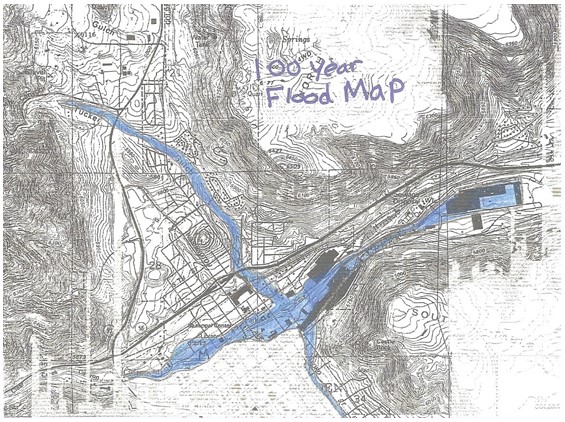
Hazard report, which should be provided in this paper is related with the flood, and the matters of credibility, as well as the periodicity of the floods in the regarded region. The aim of this paper is to summarize the data provided on the maps, and give the outline of the allover hazard. The importance of the provided information is covered in the notion that the data on the hazards may be used for the research of hazardous regions, and forecasting the further hazards, if their credibility is high enough.
As for the quality of the data, it should be stated that the quality of thee images is not high, nevertheless, the information provided is of high importance for the hazard analysis.
Rock Types Review
Originally, these are the Rocky Mountains of the Golden Valley in Colorado. As for the geological facts of this geographic area, the following statement should be taken into consideration:
The mountains’ geology is a complex of igneous and metamorphic rock; younger sedimentary rock occurs along the margins of the southern Rocky Mountains, and volcanic rock from the Tertiary (65 million – 1.8 million years ago) occurs in the San Juan Mountains and in other areas. Millennia of severe erosion in the Wyoming Basin transformed intermountain basins into a relatively flat terrain. (Plummer and McGeary, 2002, p. 310)
The distribution of these rocks is from the British Columbia, in Canada, to New Mexico, in the United States.
Overlay Maps

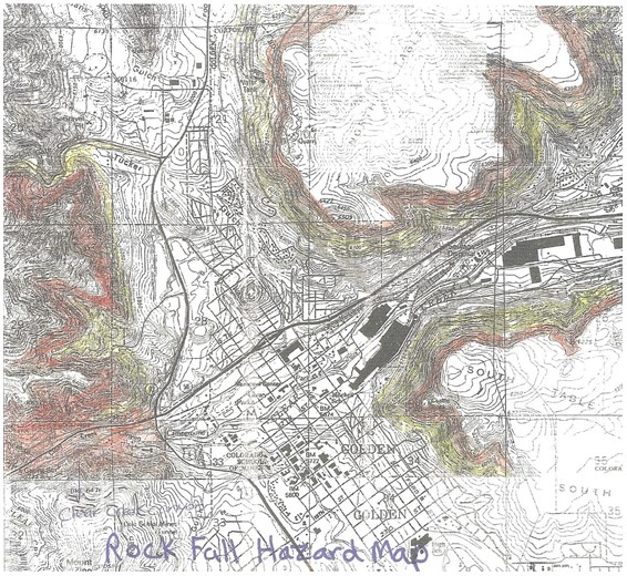
The overlay map of the hazard and the threat of the hazards as they are represented on the map are considered the lower territories. Originally, the rocky territories are not subjected to floods, nevertheless, the erosions have made the rocks subjected to falls, and consequently, the rock falls are credible enough. (Zumberge, Rutford, 2008) These territories are represented on the following map:

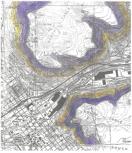
Because of erosion and floods, as well as high level of the ground waters the landslides are also credible:

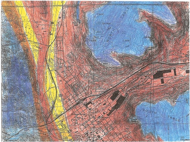
The related problem is the soil swelling.

Hazard Types
Originally, the types of the hazards which are credible, and which are common for the Rocky Mountains region are represented on the maps. These types are rock fall, flooding, swelling soils and landslides. (Zumberge, Rutford, 2008)
Flood is originated by the high levels of the ground waters and melting of the snows during the warm periods of the year. The regions, which are subjected to this hazard are the lower territories, and, in accordance with the map these territories are not extensive, thus, the damages are minor. The mitigation generally entails the dumb building. (Tarbuck, Lutgens, 2004)
Rock fall is generally caused by the erosion of the rocks for millions of years. Thus, the rocks become fragile. The parts of the rocks fall from the height, thus, acquiring immense power and ruining everything on their way. The scales of the damages may be large enough. It can not be mitigated, thus, the only way t minimize the damages is to remove any activity from the hazardous region.
Landslides are caused by the erosion and ground waters simultaneously. They do not cover large territories, nevertheless, the damages may be serious enough. Landslides may be mitigated by forestation of the region.
Land swelling is caused by the movement of the geological layers, thus causing swelling. It covers almost the whole territory of the Golden Valley nevertheless, the damages are minor.
Recommendations
The only recommendation that should be given is to avoid settling in the hazardous regions. If land swelling and floods appear to be the least dangerous, it is significant to avoid rock falls and landslides.
Reference List
Plummer, C.C., McGeary, D. Physical Geology. McGraw-Hill Science/Engineering/Math 2002.
Tarbuck, E. Lutgens, F. Earth: An Introduction to Physical Geology. Prentice Hall, 2004.
Zumberge, J. Rutford, R. Laboratory Manual for Physical Geology. McGraw-Hill Science/Engineering/Math 2008.