March 24, 2021

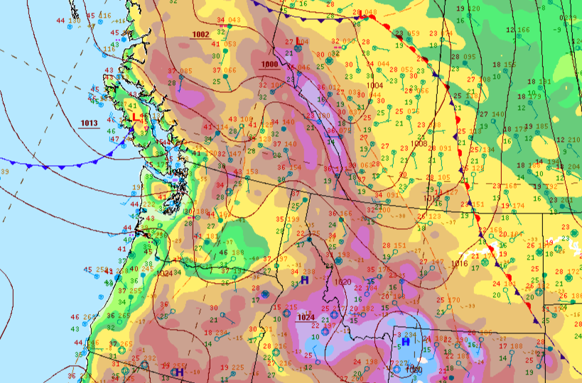
Weather analysis of March 24, 2021, consists of four time periods. The first is from 12 am till 6 am; the second is from 6 am till 12 pm. The third is from 12 pm till 6 pm, and the fourth is from 6 pm till 12 am. Vancouver was in a high-pressure area at the periphery of the well-developed anticyclone; therefore, the weather conditions are similar to those in the neighboring cyclones. The weather could be determined by a cold, stable air mass and an approaching warm front. Referring to the weather map, Vancouver was at the northern periphery of the anticyclone and the cyclone’s warm sector.
During the first interval, the temperature varied between 6 and 7°C. There was light rain, mostly cloudy. Humidity was estimated at 86%; barometric pressure data was 102.04 kPa (March 2021 Weather in Vancouver, n.d.). The weather was characterized by the wind from the east at 16 km/h (March 2021 Weather in Vancouver, n.d.). From 6 am till 12 am, some figures were slightly changed; for instance, the temperature dropped to 4 °C; there was a high humidity level – 90% (March 2021 Weather in Vancouver, n.d.). The wind direction was east-southeast at a speed of 11 km/h (March 2021 Weather in Vancouver, n.d.). In the afternoon, the forecast showed the decreased wind speed to 6 km/h (March 2021 Weather in Vancouver, n.d.). In the evening, the temperature was 6°C; humidity stayed at the same level; barometric pressure was 100.78 kPa; the wind was blowing from the west-southwest at 8 km/h. (March 2021 Weather in Vancouver, n.d.). Due to the anticyclone’s northern periphery, the weather conditions were marked by clouds with light precipitation.
March 25, 2021

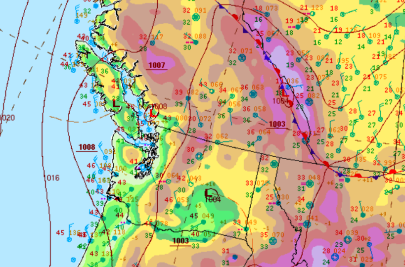
With regard to the weather map, Vancouver was in a low-pressure zone on March 25, 2021. Such areas usually have a cloudy sky, which minimizes daily temperature extremes. On the night of March 25, the temperature was 5°C, humidity stayed at a high level of 90%. The pressure was 100.77 kPa with the west-northwest wind at 9 km/h. There was no precipitation; the sky was cloudy (March 2021 Weather in Vancouver, n.d.). A low-pressure area is characterized by inclement weather. After a while, the wind suddenly increased and became blustery. From 6 am till 12 pm, the temperature rose to 9°C; broken clouds covered approximately 80% of the sky (March 2021 Weather in Vancouver, n.d.). Humidity slightly decreased to 84%, while the wind speed increased to 19 km/h (March 2021 Weather in Vancouver, n.d.). The wind blowing all day and getting stronger with the onset of night indicates a cyclone’s approach. The wind was changing direction clockwise; a steady west south wind suggested that the location was in the cyclone center.
The wind is initially accelerated from high-pressure areas to low-pressure areas. Due to the significant difference between these areas, the wind speed was high. Thus, low-pressure areas are associated with stronger winds. It was proved by the afternoon weather as from 12 pm till 6 pm; there were passing clouds; humidity continued diminishing with the measures of 72%; the wind reached 23 km/h (March 2021 Weather in Vancouver, n.d.). In the evening, the humidity was measured at 80%; the barometric pressure was 101.67 kPa; there was no precipitation; the west-southwest wind speed decreased to 8 km/h (March 2021 Weather in Vancouver, n.d.). Therefore, the changes in wind direction were mainly due to entering the low-pressure area.
References
March 2021 Weather in Vancouver.(n.d.). Time and Date. Web.
Surface analysis 12Z Wed Mar 24 2021. (2021). National Weather Service. Web.
Surface analysis 12Z Wed Mar 25 2021. (2021). National Weather Service. Web.