Map comparison
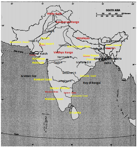
The physiographic maps of South Asia and Africa are analogous and this is owed to the tectonic plate movement as explained by Wegener’s hypothesis of continental drift theory. To this end, Wegener believes that the earth’s crust is composed of mobile tectonic plates that are a reason behind the physical features that don the earth today.
With regard to aforementioned plates the similarities come in the location of the mountains on the plates. Considering the two plates it is evident that the mountain ranges (Himalayas and Ethiopian highlands) are skewed toward the northeastern side of the plates.
This is a manifestation of compression forces that happen when plates collide causing the lighter ones to ride over the weightier ones. As a consequence these regions are known to experiencing earthquakes and, have active volcanoes.
However, the physiographic difference between the two maps is that while the northern side of South Asia is donned with rivers its North African counterpart is a desert (MacLeod and Jones 677).
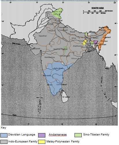
The pattern of linguistic map of India is a manifestation of cultural evolution over the past thirty centuries and beyond. About thirty-five centuries ago Indo-Aryan group had established their foothold on the Indus basin, organizing the discrete cultural groups into a unity that practiced Hinduism. As a consequence, kingdoms emerged as well as new religion- Buddhism.
Several years down the line and with the foreign influence emanating from the Persians and Greeks, the Hindi speaking people were restricted to the extreme east. As such, northern India is a region of cultural infusion i.e. Indo-European.
In the contrary, the south which is believed to have been engaged by the Dravidian speaking people long before the Indus basin civilization remained intact. Consequently, the major ethnic group synonymous with this region remains to be the Dravidian ethnic community (Kimble 510).
Agricultural production and climatic conditions of a region are inseparable, and as such they play to favor the growth of certain crops as opposed to others. This is clearly manifested in India where humid equatorial climate characterized by short winters favor the growth of wheat and rice in the northern and eastern parts of India respectively. The area receives precipitation of between 100 to 200 mm per annum.
A belt of humid temperate climate stretching from the north towards the south but, biased on the western part of India is the reason behind thriving cotton farming. This area is typified by precipitation of between 50 to 100 mm per annum.
Just like India, Sri-Lanka’s agricultural production is largely dominated by rice production. Akin to India, this area receives precipitation of between 100 to 200 mm but, has relatively long dry spells. This climate covers almost all the entire region but southwest (characterized by humid climate devoid of dry spells).
Since the inception of Islam in the Indian realm in the early 20th century the Indian-Muslim population has been experienced changes hitherto. In an effort to comprehend these changes a three-tier map coinciding with the years 1931, 1951 and 1991 is observed.
As portrayed by the maps, the Islam religion emanated from northwest consequently converting most of the Indians in these regions. Consequently, owing to an overwhelming influence it spread towards the east with a greater percentage of converts skewed towards the state of Bangladeshi. However, efforts to actively spread southwards were often thwarted by a rather placid Hinduism culture.
To this effect, until the year 1991, this region has had a minute percentage of Indian-Muslims. Nevertheless, in the central region of India (Chhattisgarh and Madhya-Pradesh) Islam boasts a relatively high degree of Muslim converts vis-a-vis Muslim population as at the year 1931(Schaefer 230).
Map 1: Physical geography of Southwest Asia.

Map 2: Political cultural information.

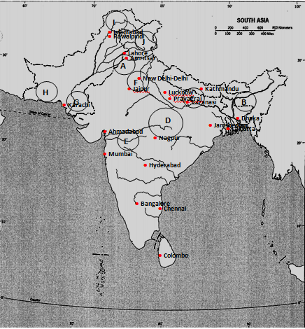
Map 3: Economic Urban Information.

Key:
A-Punjab B-Assam C-Bihar-Bengul Industrial Region D-Chota Nagpur Industrial region E-Maharashtra-Gujarat Industrial Region F-Delhi Conurbation G-Sindh H-Baluchistan I-Hindustan J-Vale of Kashmir
Works Cited
Kimble, Hebert. “The Inadequacy of the Regional Concept” London Essays in Geography 2.17 (1951): 492-411. Print.
MacLeod, George, and Jones Mother. “Renewing The Geography of Regions.” Environment and Planning 16.9 (2001): 669-800. Print.
Schaefer, Frankline. “Exceptionalism in Geography: A Methodological Examination.” Annals of the Association of American Geographers 43.3 (1953): 226-245. Print.