Meteorites give clues to planet formation
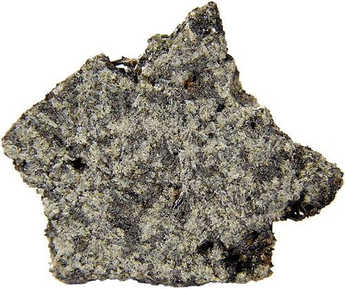
Ancient meteorites (angrites), among the oldest rocks ever found, provided clues about the conditions at the formation of our solar system. Analysis of 3 angrites showed that during the early stage of solar system formation, planetary accretion, smaller objects than previously thought possible melted almost completely. The conclusion was made by linking the magnetism of meteorites to the formation of a dynamo. When planetesimals melt, the heavier, iron-rich materials sink to the core and rotate, producing a magnetic dynamo. The origin of the magnetic properties of meteorites was previously a mystery. This study points towards planetesimals truly being tiny planets themselves, complete with cores and crusts, and not cold, rocky lumps as previously assumed. The strengths of the magnetic fields found in the study are up to 40% as strong as the Earth’s today, despite forming relatively soon after the birth of the solar system itself. The formation of the solar system may have then been a faster process than was first thought.
The study links to Chapter 1 (Geology and the Earth) by providing more detailed insights into the origin and evolution of the solar system and the Earth. The idea now presented; that planetesimals may have been already partially molten before collision, could have implications on how we understand our own planet’s formation, and specifically the distribution of elements and minerals throughout the layers of the Earth.
New activity at Krakatau
Krakatau, in Indonesia, most famously erupted in 1883, blowing apart the existing island, and forming devastating pyroclastic flows and tsunamis that swept across the surrounding ocean and killed more than 36,000 people. Following this, the area was quiet for some time, until 1927, when the new cone of Anak Krakatau (Child of Krakatau) began to grow in the caldera of 1883. This site has been the site of frequent small eruptions since 1927, the most recent activity occurring in 2009. Center of Volcanology and Geological Hazard Mitigation (CVGHM) reported that seismicity from Krakatau increased during 19-25 March. On 25 March, white/gray plumes rose up to 400 m above Anak Krakatau. The Alert Level for the volcano was 2 (highest is 4). During 27-30 March and 1 April, ash plumes again rose high above the Anak Krakatau crater, this time reaching 200-800 m. An ash eruption on 2 April, and resultant ash plume was seen on satellite imagery and reported by a pilot. The ash plume drifted more than 60 km to the south. The Alert Level remained at 2. These activities followed a mass of activity in the summer of 2008, and show that, while the current eruptions are in no comparison to that in 1883, the volcano can still be considered dangerous.
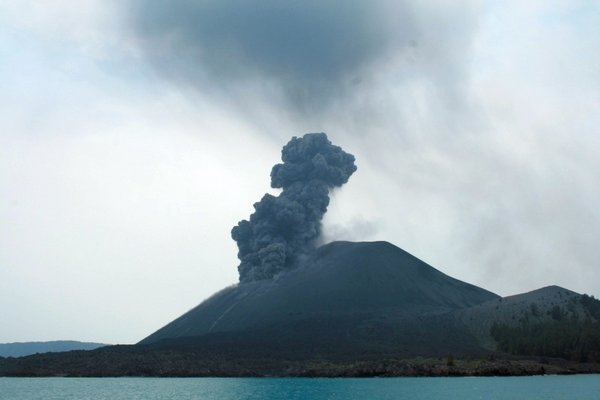
This event links to Chapter 5 (Plutons and Volcanoes), and shows that volcanoes are not always one-time events, and can be always changing and evolving. Krakatau erupted very violently in 1883, and is now re-building, so that in the future it may erupt catastrophically again.
Algerian desert flood
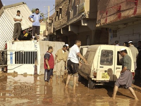
A flash flood in the sub-Saharan region of Algeria on October 2nd, 2008, caused massive damage to the town of Ghardaia and was responsible for the death of over 30 people. The storm was described as the worst in a century, causing a local river to rise by 26 feet, water levels to reach eight metres high in some parts of the town, and chest-deep mud to run through the streets. The town Ghardaia is found in a long narrow desert valley (the M’zab). The river bed is usually dry most of the year, and deadly floods are rare. However, Algeria, and other countries surrounding the Sahara, have been subject to several floods in recent years. In 2001, one flood event lasting 2 days struck the north of Algeria, killing at least 700 people and injuring many more.
Flash floods of this kind in desert areas that are normally bone dry create very recognizable sedimentary structure, especially when directed through valleys, or wadis. Deposition in a wadi is quick when the floods waters recede, as the velocity of the stream rapidly decreases and water seeps into the porous sediment. Deposits are then usually poorly-sorted, consisting of gravels and sands. This flood event links to Chapter 7 (Sedimentary Rocks) by demonstrating one depositional environment that exists only temporarily, and leaves a very distinct record, as opposed for example to a river, that leaves a record of continual deposition over an extended period of time.
Happy birthday, Darwin
February 12th, 2009, marked the 200th anniversary of Charles Darwin’s birth, the influential author of ‘On the Origin of Species’. Darwin’s ideas not only covered evolutionary biology, but considered the implications of natural selection on the age of the Earth. At the time, most people believed the age of the Earth to be around 6000 years, according to one translation of the Bible, but geological evidence was beginning to mount for a much older Earth. Based on geology, Darwin made a crude estimate of the age of the Earth of several hundred million years. This satisfied his requirements for the process of natural selection to produce the wide variety of species found on Earth today. Around the same time, though, thermodynamical calculations made my Lord Kelvin predicted a much younger Earth, causing problems for Darwin’s theories. Fortunately, Lord Kelvin’s calculations were found to be wrong, since he did not account for the then unknown internal heat source of nuclear radioactivity. Radioactive dating now confirms that the Earth is around 4550 Ma old, plenty of time for natural selection to occur.
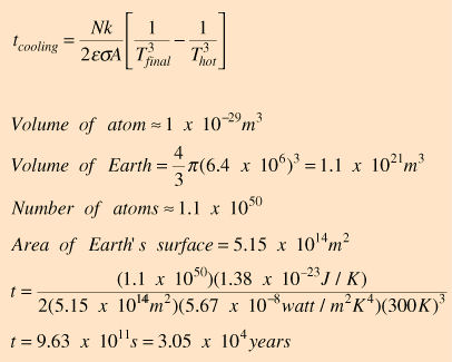
Kelvin calculated a radiative cooling time for the Earth by assuming that the Earth was once very hot, and had since cooled to about 300°K by radiation into space. The cooling time can be modeled using the equations to the right, resulting in a cooling time for the Earth of about 30,000 years. The discovery of radiation gave a mechanism by which the Earth could be kept hot long after the radiative cooling time. Darwin’s ideas on natural selection relate to Chapter 9 (Geologic Time: A story in the rock) by considering the development of our modern geological column and time scale, and the absolute age of the Earth.
Earthquake rocks central Italy
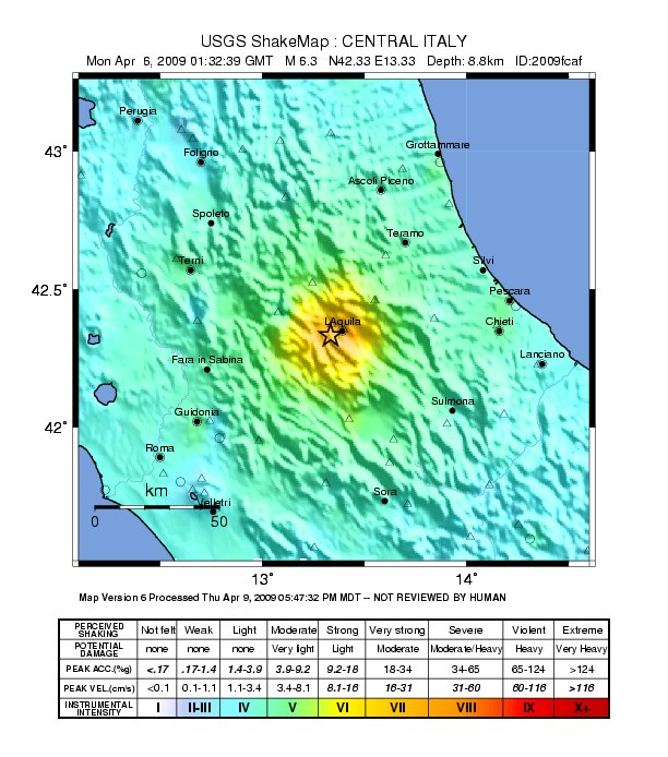
The most recent geological event to reach world headlines was the deadly Italian earthquake, on April 6th. The magnitude 6.3 earthquake killed at least 227 people, injured around1,000 more and resulted in 10,000 buildings being damaged or destroyed. The quake occurred in the L’Aquila area of Italy, 55 miles NE of Rome, and the quake was felt throughout central Italy. The earthquake has been followed by several strong aftershocks of magnitude greater than 5 on the Richter scale, one occurring on the 7th, and two on the 9th April. This event relates to Chapter 10 (Earthquakes and the Earth’s structure), and provides a case study of an old plate boundary still active. The moved occurred along a normal fault in the central Apennines. The Apennines run from the Gulf of Taranto in the south of Italy to the southern edge of the Po basin in the north. The fault responsible then extends NW-SE. The movement along this fault is a consequence of the Tyrrhenian basin to the west opening faster than the African plate is pressing against the Eurasian plate, acting to close the Mediterranean.
Continuing evolution of Hawaiian Islands
Kilauea has historically been Hawaii’s most active volcano, and had continued erupt into 2009. The activity is mainly slow-flowing lavas and small plumes, so that it poses little threat to the inhabitants, although lava flows quite often run over infrastructure links. During 1-7 April, USGS Hawaiian Volcano Observatory (HVO) reported that lava flowed from underneath a previous flow through a system of lava tubes, reaching the ocean. Along the coast, more lava flowed on the surface and was recorded by satellite imagery. Where one of the lava tubes reached the ocean there were some small explosions as it came into contact with the water.
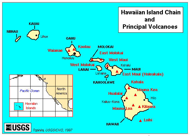
The island chain is in the mid-Pacific, and is formed above a ‘hot spot’ rising from deep beneath the crust. The mantle plume that forms the hot spot remains stationary, while the crustal plates move above it, creating the islands that delineate the direction of movement.
This event links to Chapter 11 (Ocean Basins) by providing evidence of continued formation at one of the world’s most famous island arcs. The activity is now concentrated on the island of Hawaii. As the activity wanes to the West, those islands (e.g. Niihau and Kauai) now starved of material begin to shrink from constant attack by the sea. Kilauea is the most South-Easterly volcano on Hawaii, and so received the most new material and activity at present. However, there is a new seamount (Loihi) forming to the south of Kilauea, which will likely become the new focus and form a new island in the chain in the future.
Continuing evolution of the Andes
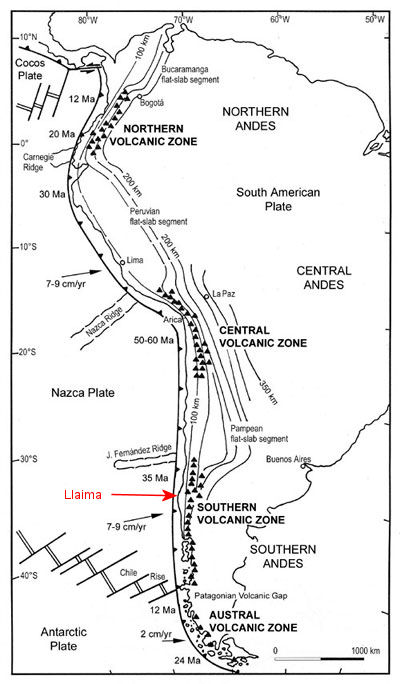
As with the island chain of Hawaii, the mountain belt of the Andes was also seen to evolve and grow in the past year, with the eruption of Llaima in central Chile. In July 2008 the volcano began a relatively vigorous phase of Strombolian eruption, ejecting lavas and ash plumes that reached up to 6 km into the atmosphere. Near the end of July, the alert level in the region of the volcano was raised to ‘red’, following lava and ice interactions. Melted ice can cause sudden rapid floods and mud flows (lahars) that can be devastating. Currently, the volcano is still erupting, and the alert level was raised to red (maximum) on April 4th, causing the evacuation of 71 individuals living nearby. Lahars and lava have travelled down the mountain sides and rivers, and heavy ashfall and volcanic bombs litter the area. Although never particularly violent, the position of a glacier at the summit creates many hazards related to lahars.
The new activity at Llaima relates to Chapter 12 (Geologic Structures, Mountain Ranges, and Continents), as it demonstrates one way in which mountain ranges are currently being built. Llaima lies in the Southern Volcanic Zone of the Southern Andes. Here, the denser oceanic Nazca Plate is subducting beneath the lighter South American Plate. The partial melting of the plate upon subduction leads to a rise of buoyant molten material that erupts out of a line of volcanoes. These primarily form the Andes, Llaima being one of the most active volcanoes in this portion of the mountain range, erupting over 30 times in the 20th Century.
Quake causes devastating landslides
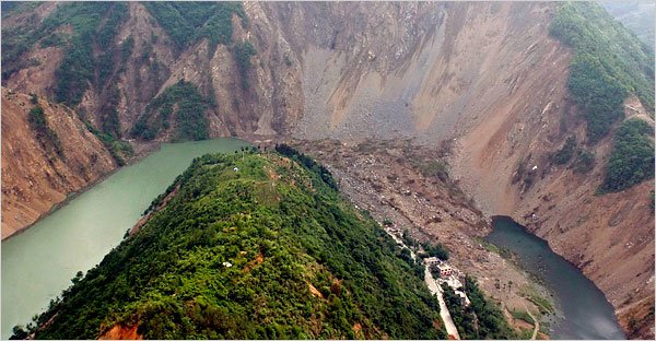
The earthquake of May 12th, 2008, in the Sichuan Province of China measured 8.0 on the Richter scale and killed an estimated 69,000 people. In the aftermath of the quake, numerous landslides triggered by the activity continued to cause death and injury, and greatly hampered relief efforts. Many rivers also became blocked by landslides, resulting in the formation of ‘quake lakes’, where water pooled behind landslide dams. These dams are likely to break under the water pressure and pose a serious hazard to nearby villages, although many of them were evacuated due to the flooding. Some attempts by the Chinese military were made to blast and dig channels into the landslide dams to relieve the pressure in a controlled way.
These landslides link to Chapter 13 (Mass Wasting) by demonstrating several mechanisms for landslide triggering in landslide-prone areas, and how sometimes many factors act in combination to cause a landslide or mudslide event. The Wenchuan County, around the epicenter of the quakes, is characterized by deep valleys enclosed by high mountains with steep slopes, creating ideal landslide preconditions. Numerous aftershocks continued to destabilize the slopes. Many cracks in the mountains around Guangyuan City were reported, leading o the evacuation of nearly 9,000 people. Conditions were made even more suitable for landslide triggering by the persistent heavy rain that thrashed the area. Landslides we then mudslides, with a larger capacity to travel and cause damage. The avalanches killed thousands, destroyed, and shredded water and power stations, among other facilities.
Midwest flooding strikes Iowa hard
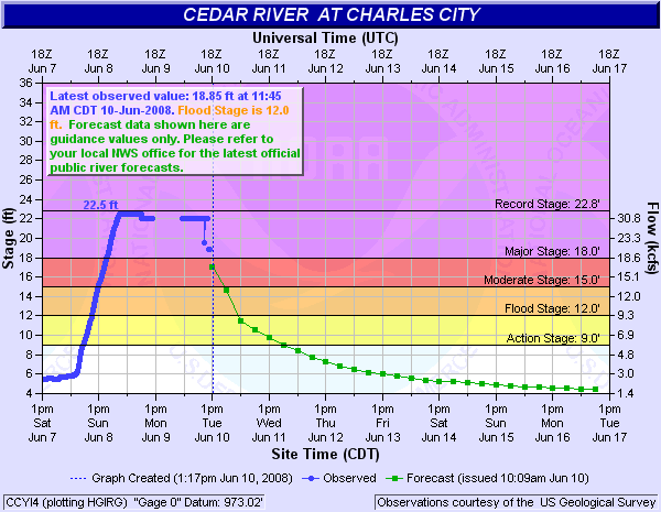
In the summer of 2008, a major flood event occurred in Iowa, involving most of the rivers in eastern Iowa. The floods were the result of a severe snow-bearing winter in the northeast of the state, coupled with heavy rain and thunderstorms in April and the late-May ‘2008 tornado outbreak sequence’. The extraordinarily wet start to the year, the wettest January to June period on record in Iowa, caused many rivers to break their banks, with Cedar Rapids reaching ‘500-year event’ flood levels, and causing the evacuation of nearly 4,000 homes. Across the state, levees were topped and homes were evacuated, and thankfully casualties kept to a minimum. The event links to the floods section of Chapter 14 (Fresh water: streams and lakes). The flooding was part of a larger pattern of flooding across the Midwest states, but central Iowa and Cedar Rapids were the worst hit. On June 13th, a crest on the Cedar River broke the previous record height by nearly 11 feet. Many towns in Iowa received their wettest months on record (e.g. Dorchester and St. Ansgar). Imposed on the trends of wet Mays, Junes and Julys were unique flash flooding events, such as that on June 12th. Earlier in the week, heavy rain and frequent thunderstorms had struck the area, followed by storms bringing hail and high winds.
This image shows the hydrograph for a portion of the Cedar River during the height of the flooding. There were no river level measurements after 8 pm Sunday night since the gage was underwater.
Iceland’s geothermal boom
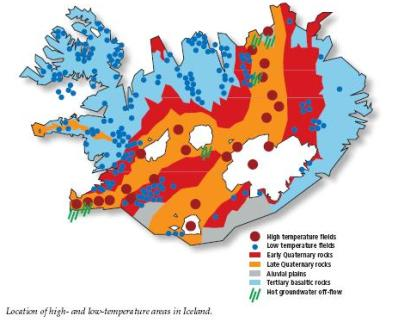
Not exactly a geological event, but the severe economic crisis in Iceland has led to an increased interest in its geothermal resources as an opportunity to relieve the situation. The country began exploiting geothermal power sources 70 years ago, and sees the current global focus on climate change as an opportunity to benefit from its success with the relatively clean energy source. Iceland gets 62% of its primary energy from geothermal sources, and more is used for space heating. Physically exporting the excess energy produced in a country with only 300,000 residents and abundant resources proves difficult due to the island’s position in the North Atlantic (although there have been plans to lay pipelines to the UK). The energy then is mostly exported via production, for example through a major new aluminum smelter recently constructed. However, the country also plans to profit from exporting its vast knowledge of harnessing geothermal power. As well exporting energy directly and via production, Iceland aims to use geothermal energy to increase tourism to the country, through health and wellness (such as the Blue Lagoon spa).
This article links to chapter 15 (Fresh Water: Ground water and wetlands) that describes the origins of hot springs and geothermal energy. Iceland’s geothermal resources stem from its position on the Mid Atlantic Ridge, and over a hot spot, providing massive heat from the Earth’s interior. There is a lot of hot water and steam beneath the surface, and much of it is near enough to the surface to tap.
Bibliography
De Montesquiou, A., 2008. Death toll up to 33 in Algerian desert flood. USA Today, Web.
Lacey, S., 2008. Geothermal Energy Leaves the Window Open for Iceland’s Economy. Renewable Energy World, Web.
NASA Earth Observatory, 2009. Wenchuan Earthquake Mudslides Emit Greenhouse Gas. Web.
National Oceanic and Atmospheric Administration (NOAA) National Weather Service, 2008. 2008 Iowa Weather in Review. Web.
Smithsonian Institute Global Volcanism Program, 2009. Krakatau, Kilauea and Llaima. Web.
Stenger, V.J., 2003. Darwinism and the Age of Earth. Web.
USGS, 2009. Earthquake Hazards Program. Web.
MSNBC, 2008. Meteorites give clues to planet formation. Web.