Definitions of Terms
Subtropical highs
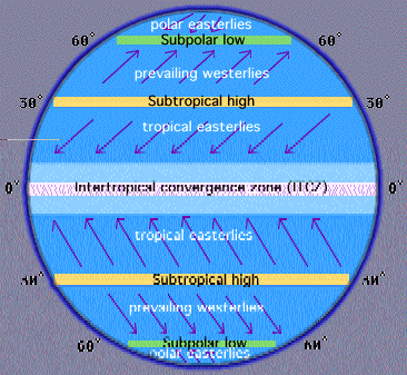
This is a significant belt or region of high pressure that lies around the latitudes 30°N and 30°S in the Northern and Southern Hemispheres respectively. The regions are usually characterized by calm winds, fog at night and haze during the day. The figure below shows subtropical highs as show in the southern and Northern hemispheres respectively.
Intertropical convergence zone (ITCZ)
This region encircles earth near its equator and acts as the meeting point for winds from Northern and Southern hemispheres. It is characterized by violent thunderstorms and stagnant calms; in addition, it brings conventional precipitation. In essence, the region possesses an erratic weather pattern. It lies approximately within 5°N and 5°S. The figure above shows ITCZ.
Monsoon
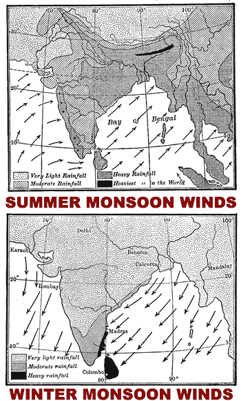
The term monsoon refers to a seasonally reversing wind whose presence is usually characterized with a change in precipitation. It is also utilized in describing seasonal atmospheric circulation. Moreover, it is also utilized to describe precipitation associated with regions that receive asymmetric heating of both sea and land. A vivid example is Indian climate, among others. The figures below show both the summer and winter monsoon winds.
Jet stream
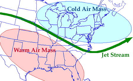
This refers to narrow currents that are fast flowing, and usually found in the atmosphere of some planets, for instance the earth. For instance, in the Earth, jet streams are usually located in or close to the tropopause and stratosphere, where temperatures decrease with altitude and increase with altitude respectively. These are usually found in the upper part of the atmosphere. The figure below shows an illustration of Jet Stream.
Hadley cells
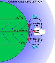
This is a circulation pattern in the tropical atmosphere that was named after George Hadley. The pattern is commonly found in the tropical region and shows rising motion close to the equator. It also conveys a 10-15km above the surface flow pole-wardsand depicts descending motion in the subtropics. In addition, it conveys equator ward flow near the surface. The figure below shows the Hadley Cell.
Polar front
This is the zone of transition that exists between the Ferrell and Polar Cells respectively, in each of the hemispheres. Sharp gradient is commonly associated with this zone between the two air masses as they occur in completely different temperatures. The figure below illustrates a polar front
Orographic lifting
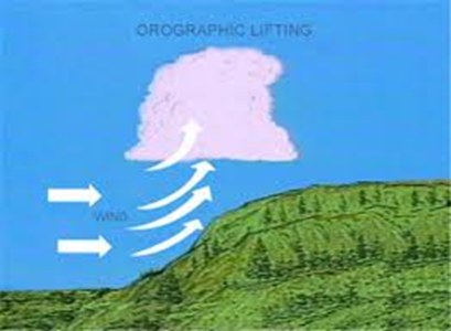
This term may refer to upslope flow, forced land lifting as well as topographic uplift. It happens in situations where an air mass is lifted from a lower level as it clears on a rising terrain. In essence, what happens is the adiabatic cooling of air mass as it gains altitude. This has the effect of raising its relative humidity to 100% thereby creating clouds or precipitation when under favorable conditions. This is illustrated as shown below.
Cumulous vs. stratus vs. cirrus clouds
These are heaped vs. layered vs. fibrous clouds respectively. In essence, cumulous clouds comprises of heaped clouds, separated by a clear space with vertical thickness that can go up to 30000ft. on the other hand, Stratus clouds comprise of layers clouds which tend to form a sheet covering a large area with the capability of 1000s of feet in thickness. In addition, Cirrus clouds comprise of fibrous clouds with hair like structure. They are usually found at high levels and are composed of ice.
Cumulonimbus clouds
These are heavy masses of clouds with a great vertical development. Their summits rise in form of towers or mountains. The upper part spread in form of anvil and is quite fibrous. It is usually characterized by heavy showers of rain.
Super-cooled water droplets
These are water droplets that exist in form of liquid at temperatures below zero degrees. Most clouds at temperatures of between 0°C to -15°C contain largely of super-cooled water droplets.
EINino
This refers to the warming of ocean surface off the South American Western coast every 4 to 7 year and usually when upwelling of nutrient rich or cold water does not occur. The result is the die offs of fish and planktons, and effects on pacific jet stream wind. This alters storm tracks thereby creating an unusual weather pattern in parts of the world. El Niño therefore results from piled up warm water flow from the western pacific towards South America. It may also refer to a predictable climate fluctuation.
Rossby waves
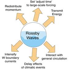
These are giant meander that occurs in high altitude winds and greatly influence weather. They are a subgroup of inertial waves and occur mainly due to shear in rotating fluids. They are illustrated in the diagram below.
Dew point
The term is usually employed to describe a temperature to which a specific portion of moist air must be cooled to condense into water, at a constant atmospheric pressure. It refers to a saturation temperature with the condensed water being the dew.
Relative humidity
This term refers to the amount of moisture present in the air compared to the amount of moisture the air can hold at that temperature.
Adiabatic lapse rate
This is the rate of decrease in temperature of an air parcel, with an increase in altitude that expands slowly without exchange of heat to a lower atmospheric pressure. When used to refer to a descending parcel of air. It refers to the rate of increase in temperature with decrease in altitude. They exist in two, the moist and dry adiabatic lapse rates. The former is usually less than the latter.
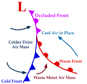
Occluded front
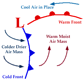
This usually happens when the cold front catches the warm front, especially in situations where there are intensified storms. This is illustrated as shown below.
Mediterranean climate
This type of climate also refers to the dry summer climate of the subtropical region. It is called the Mediterranean since the climate is largely evidenced in a region that borders the Mediterranean Sea. This climate is largely characterized by dry summer and wet winter in terms of precipitation. Most plants in this region have to adapt t summer droughts as is usually observed in scrubs. The regions largely affected are the coasts of Mediterranean Sea as well as the western side of the subtropical continents.
Mid-latitude steppe climate
This kind of climate is sometimes referred to as semi-arid. When a place is located on the leeward side of a mountain, then it is highly likely that it will experience this climate. It is characterized by large ranges in temperature. In comparison tropical steppe climate, it receives more rainfall. This climate exists mainly in the mid-latitude continents, mainly in the Northern hemisphere, where sources of moisture are rare. For instance in rain shadow of very tall mountains like the Rocky Mountain in North America and the southwestern Russia.
Tropical wet climates
These areas are characterized by annual warmth in terms of temperatures. For instance, the mean temperatures of all the months are either 18 degrees Celsius or above. They also receive abundant rainfall that exceeds 150cm per year. These region covers between 15 to 25 degrees south and north of the equator. The regions experience very little seasonal temperature variations and receive constant solar radiations. Afternoons are associated with convective showers, as seen in Iquitos, in Peru, among others.
Coriolis Effect
This term coriolis is commonly used to refer to a deflection of objects in motion as can be seen in a reference frame that rotating. Left deflection occurs in clockwise rotation, while that to the right occurs in anticlockwise rotation.
Evapotranspiration
This term is usually used to refer to processes through which water gets transferred to the atmosphere from the earth’s surface. These may include transfer of water from ice surfaces, vegetation, open water, and bare soil, among others. It may also be used to refer to both evaporation and plant transpiration.
Condensation nuclei
This term is usually employed to refer to tiny materials or particles such as dust, smoke or aerosols, whereupon water vapor condenses into droplets of cloud. These are usually less than or equal to 0.2 micrometers in size.
The association between pressure and temperature
When pressure increases, temperature increases. This means that an increase in pressure will lead to an increase in temperature. Near earth, surfaces are always areas of high-pressure concentration due to the weight of air mass. This exerts pressure on the surface, and causes higher friction of air mass with the surface of the earth. The resulting effect is heat generation, which raises the temperature.
Isobars, pressure mapping, and pressure gradient
Isobar refers to a line joining point with the seam atmospheric pressure. Pressure mapping, on the other hand refers to the process of quantifying pressure in different places. Furthermore, pressure gradient refers to the change in pressure, usually measured across a specific distance from one point to another. These are used to map pressure and ascertain isobars.
The nature of wind -its flow aloft and at the surface (geostrophic ~the role of friction, etc.)
Wind is the movement of air from regions of high pressure to those of low pressure. Wind flows from high-pressure atmospheric domes, below which air sinks to regions of low pressure.
The difference between cyclones and anticyclones (low pressures and high pressures)
Cyclones is characterized by lowest pressure at its center, while anti cyclones are characterized by highest pressure at its center. Strong winds observed due to tight gradients or close isobar in cyclones, while low winds are observed in anticyclones due to spaced isobars or light gradients.
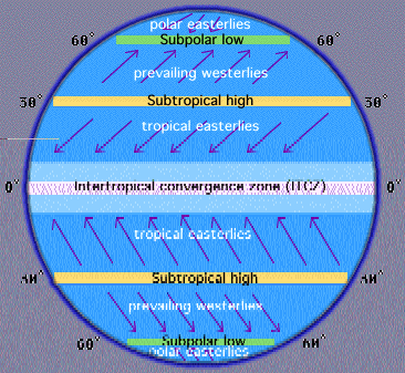
The general circulation of the atmosphere (ITCZ, subtropical highs, trade winds etc.)
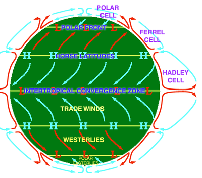
The general circulation of the atmosphere is as shown below.
The four different localized wind systems (sea and land breezes, valley and mountain breezes etc.)
There are five local winds; these are Sea breeze, land breeze, katabatic winds, Anabatic winds and Fohn winds.
Characteristics and effects of EI Nino
The result is the die-offs of fish and planktons, and effects on pacific jet stream wind. This alters storm tracks thereby creating an unusual weather pattern in parts of the world. El Niño therefore results from piled up warm water flow from the western pacific towards South America. It may also refer to a predictable climate fluctuation.
The association between air temperature and water vapor
Water vapor is the amount of moisture in a given parcel of air. Air temperature is the degree of hotness or coldness of air. Dry air, has low pressure and is therefore much cold as the rate of friction is lower than in moist air, which exhibits high pressure, increased molecular friction and hence higher temperature.
What conditions promote evaporation?
Exposed surface area, wind, high temperatures and low humidity
Relative humidity -how is it measured, how is it expressed, what is the dew point
Relative humidity refers to the amount of moisture present in the air compared to the amount of moisture the air can hold at that temperature. On the other hand, Dew point gives a description of temperature upon which a specific portion of moist air must be cooled for it to condense into water, at a constant atmospheric pressure. It also refers to a saturation temperature with the condensed water being the dew.
The adiabatic processes -condensation, saturation, dry adiabatic lapse rate, LCL, etc.
Adiabatic lapse rate is the rate of decrease in temperature of an air parcel, with an increase in altitude that expands slowly without exchange of heat to a lower atmospheric pressure. When used to refer to a descending parcel of air. It refers to the rate of increase in temperature with decrease in altitude. They exist in two, the moist and dry adiabatic lapse rates. The former is usually less than the latter.
Characteristics and formation of thunderstorms and tornadoes
When a column of air, which is in contact with both a cumulonimbus cloud and the earth’s surface rotates dangerously and violently, then we refer to it as a Tornado. They usually form condensation funnels that are visible and touching the earth. Thunderstorm, on the other hand, forms whenever unstable, moist air gets lifted into the atmosphere. It releases latent heat after condensation after initiation of vertical lift.
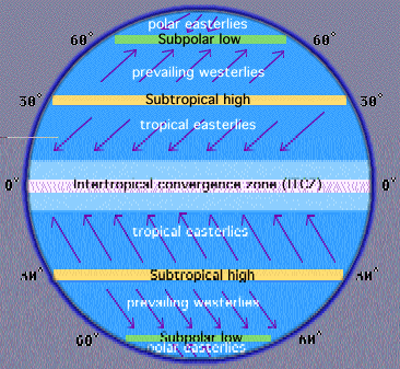
Major bands of circulation on world map
The major bands of circulation are, Subpolar low (N and S hemisphere), Subtropical high (N and S hemisphere), and ITCZ. As shown below.
Evaluating isobars
The closer the isobars, the higher the pressure gradient and thus higher pressure, meaning high wind velocity and vice versa.
Calculating temperature of a parcel of air as it rises
The formulae for calculating the temperature of a parcel of air as it rises follows adiabatic temperature changes formula. This is as follows
Amount of cooling *rate of cooling =condensation level,
Amount of temperature change = change in elevation*SAR (saturated adiabatic rate)
What happens to weather elements when a cold front passes?
A cold front is that front of air mass, which is usually cooler than that air mass in front of it. This affects several weather elements as follows
Temperature
Temperature will decrease due to cold air; this can be accompanied by precipitation.
Humidity
Humidity also decreases as less water is contained in air mass.
Pressure
Pressure will increase decrease since the cold denser air pushes the warm less dense air mass.
Wind velocity
Wind velocity decreases since the cold front is much denser.
Air mass and their letter of classification
Air mass is a given volume of air, defined by the amount of water vapor it carries and the temperature. They are usually classified according to burgeon classification. His entails the use of three letters, with the first describing moisture content and the second describing the thermal content of its source. In addition, the third letter conveys the stability of atmosphere. For instance, the first letter gives, m-maritime and c-dry. The second letter gives T-tropical, P-polar and A-arctic, M-monsoon and Equatorial. Finally, the third gives k-colder than ground, w-warmer than ground.