Exercise 1: Basics of Google Earth and Landscape Features
In this exercise, the map of Australia served the purpose for the study. In terms of the overall overlook on the map of Australia, the most distinctive feature is the desert which covers the central part of the continent, extending towards the west (Smithson 2002). Ideally, it covers almost the entire continent. This is exhibited by the brownish color, indicating that the area is dry. As such, this served as the guide in dividing the continent into two different landscapes as shown below (Bohm & Chaudhri 2000).
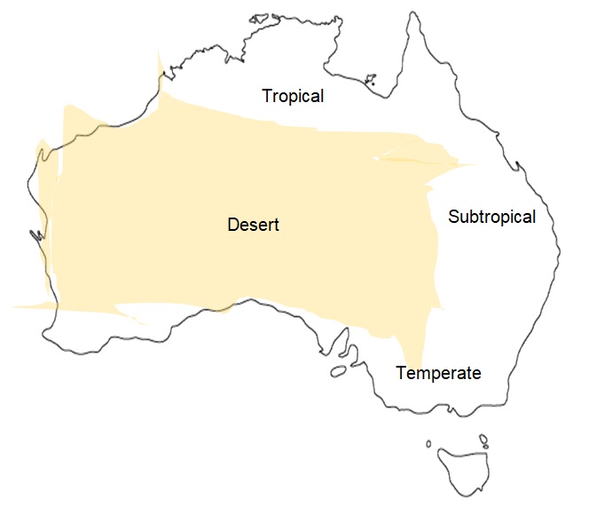
The climatic condition of Australia is a function of both the equatorial climate and the sea coast. The tropic of Capricorn traverses the continent, dividing it into the tropical north and the temperate south shown on the map above (Miller 2008).
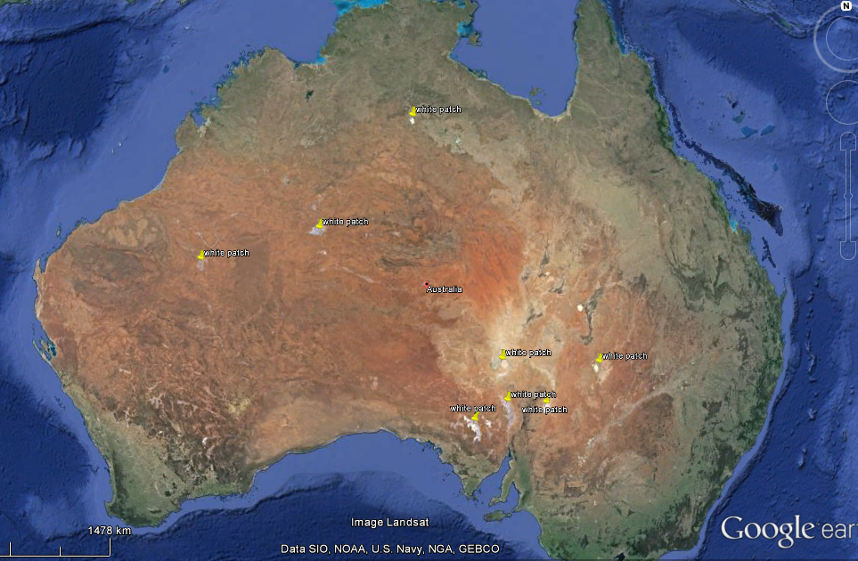
The lakes that appear as white patches on the Australian continent are shown with yellow placemarks in the map below.
The lake that is located on latitude 29°18’22.77″S and longitude 137°19’36.24″E is shown in the map below. The three distinct images present the historical images taken over time.
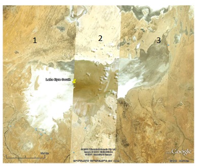
The changes in the appearances of the lake are a function of the climate change. In fact the water levels are dependent on the tropical monsoon. As such, when there is no rain the lake becomes salty (image 1 and 3). Image 2 was taken when the monsoon was strong and, therefore, the water levels were high. The brown color of water is as a result of soil erosion. The elevation of Lake Eyre South is 25 m above the sea level.
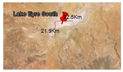
As per the measurements, the longest width (east-west direction) of the floor of the lake (Eyre South) is equivalent to 22.5 Km. On the other hand, its longest length in the north-south direction is 21.9 Km (see below).
The floor of the lake is highly varied, increasing in depth as you move towards the east from 20m to 11m in the west above the sea level.
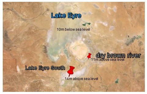
Lake Eyre North is below the sea level (-10m) while Lake Eyre South is 14m above the sea level (see the map below) (Holden 2004). As such, the flow of the river is from south to north. When both lakes are filled concurrently with water, Lake Eyre South would fill faster than Lake Eyre North since it has a small capacity (see below).
The dune shown on the location 29° 4’8.33″S and 136° 8’10.05″E is shown in the image below:
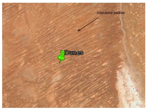
The figure below shows how the interdune distances in the north of 29° 4’8.33″S and 136° 8’10.05″E was obtained.
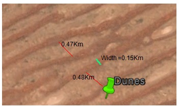
The average interdune distance was established to be 0.45Km. On the other hand, the average width was established to be 0.15Km; smaller than the interdune distance. These dunes had an average height of one metre. The orientation of the dunes with respect to the North Pole is at 63.65o. In the location 28° 36.844’S 136° 4.553’E, there are no dunes since this place is a depression and could be serving as a seasonal river that destroys dunes whenever it rains. The map below shows locations of dunes in different regions in Australia.
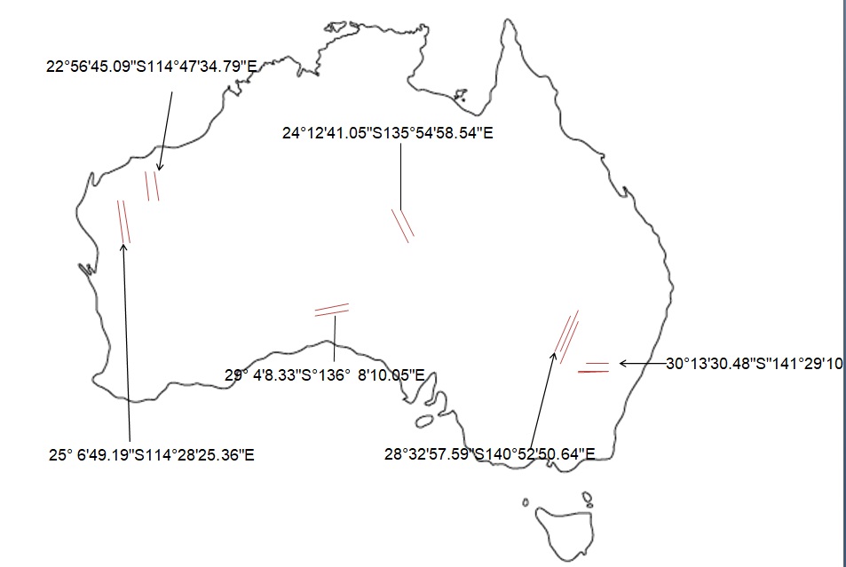
The orientation of the dunes is varied depending on the wind pattern of Australia.
Exercise 2: Map Overlays
The figure below presents the Cobaw granite region:
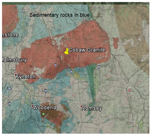
Cobaw granite and the bluish sedimentary rocks are in different altitudes. The former is located on the high land, approximately 450 m above the sea level. On the other hand, the sedimentary rocks are located on a gentle valley sloping towards the north from an elevation of 350m to 95m above the sea level at Echuca in the Murray River. This terrain explains why the tributaries and creeks on the sedimentary rocks face towards the northern side. On the other hand, on the Cobaw granite the drainage is haphazard and disjointed. Some of the factors that influence the drainage patterns of these two regions include the slope and the nature of the bedrock (Martins 2010).
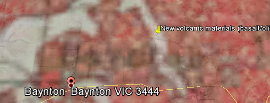
The white things that are seen on the geological map in the northeastern side of the Baynton are the newer volcanic materials that include basalt, olivine, tuff and scoria among other alkaline-based derivatives. They do happen on a hill where they are spilled over from the molten magma. See the figure below of the area.
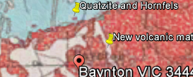
The feature that is in point 37° 6.155’S 144° 39.805’E (see below) is a valley and it is characterized by quartzite and hornfels. These materials are formed from a reaction that happens when a rock is subjected to high temperatures and pressure, transforming it to form ores. This process is called contact metamorphism (Pain & Wilford 2012).
The area in the left of Staughton Vale was not cleared in spite of it having Ordovician and Quaternary sedimentary materials since the trees in this region act as water catchment that provide fresh water for domestic, agricultural and industrial use. Importantly, these materials were eroded to this area from the north. This is owed to the fact that the terrain of the region slopes from north to south and the creeks point in the north-south direction (Dennison 2009).
Exercise 3: Exploring landscapes using GE
- Timbuktu is in central Mali and it is based on a desert landscape. The distinctive features found here are the dunes and the river (Niger). People living in the north of Timbuktu find it hard to cope with the landscape since they overlook the desert and hence they are affected by the desert winds and the adverse weather conditions.
- The Rodriguez Island off Mauritius coast is brownish in color, implying that the area is experiencing erosion after the trees were cleared by man after the 15th century.
- Maldive is an island that is on the risk of being submerged. Its average altitude is two metres above the sea level. The coastlines of the islands are curved to reduce the effects of the ocean currents from the sea (see Gan Island).
- The Darling River in Louth, Australia has a grey waterbed while the surrounding landscape is reddish. This image is due to soil erosion which has happened over a long period, sweeping away the top soil and exposing the minerals that are buried beneath the soil.
- Franz Joseph Glacier in New Zealand is as a result of moraine formation that was deposited approximately 10Km from the glacier about 12,000 years ago. With regards to elevation, the difference in altitude between Wahio Loop (29m) and the terminus end of the moraine (140m) is 111 metres.
- The expanse of cultivated land is reducing due to an increase in population; therefore, people are clearing the forest in order to create space for settlement. Also, the area of the cultivated land has reduced with the onset of industrialization.
References
Bohm, A & Chaudhri, D 2000, Australia’s physical study: an analysis of the geology of the continent, IDP Education Australia, Sydney.
Dennison, C 2009. Physical geography: A Scientific Basis for the Healthy Waterways Campaign, Thomson Learning, South Melbourne.
Holden, J 2004, Introduction to Physical Geography and the Environment, Prentice-Hall, London.
Martins, M 2010, “Land of earthquakes and volcanoes,” Australian Geographic, vol. 4, no. 6, pp. 7-10.
Miller, G 2008, Sensitivity of the Australian Monsoon to insolation and vegetation: Implications for human impact on continental moisture balance, Geology, vol. 33, no. 1, pp. 65-68.
Pain, C & Wilford, JR 2012, Flat and red-Australia’s distinctive landscape, Geoscience Australia and ANU E Press, Canberra.
Smithson, P 2002, Fundamentals of the Physical Environment, Routledge, London.