The Holocene History of Port Phillip Bay
Summary
Making a revolutionary statement in geology in general and the origin of the Port Phillip Bay in particular, Holdgate claimed that the area, which the port originated, used to be a dry land at some point. According to Holdgate, it was the “catastrophic ocean flooding” (Cauchi 2011, par. 3), which contributed to the creation of the region. While the previous existence of the lake in the place where the bay is located currently has not been proven yet, the ostensible idea of the area is dry before seems to have enough supporting evidence to be deemed as quite realistic.
Findings
Being quite credible and based on a plethora of calculations, the study will still need some tangible evidence to prove Holdgate’s point. Therefore, it is required that large-scale studies of the area should be conducted. The specimens of Port Phillip Bay’s core should be analyzed so that the corresponding data should be revealed and that the study could be supported. Specifically, the fossils of specific creatures, such as the shells of tertiary foraminifera (Wilson and Miner 2015), as well as the meanders of the river channels, which were located in the area, are bound to bolster the hypothesis suggested by Holdgate and enable the latter to prove that the amount of water in the bay reached the highest level of shrinkage ca. 1000 years ago.
Port Phillip Bay
Since Holdgate’s hypothesis presupposes that the area, in which the bay is located nowadays, used to be represented by a lake that later on dried out, there are significant changes in finding the “alluvium, lacustrine and swamp deposits” (Wilson and Miner 2015, p. 77) in the area. The specified findings, however, can be expected at the level, which the Holocene era is represented; as far as the Pleistocene pieces of evidence are concerned, the specimens of calcareous and siliceous dunes, as well as volcanic basalt (Wilson and Miner 2015, p. 77) are likely to be located in the area in question. Therefore, a range of sandy deposits is most likely to be identified at the given level of Port Phillip Bay’s evolution, as the area was represented mostly by dry land at the time (Chen, Eisma & Hotta 2013). As far as the fossils are concerned, one must bring up the aforementioned shells of the sea creatures once again, as the area used to be under water before the drastic drop in the sea levels and the following process of drying out. Hence, shells and other remnants of sea animals of the pre-Holocene epoch are expected to be located in the area as well (Patterson 2013).
Sea Levels, Dunes and Dates

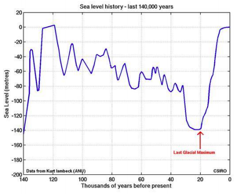
The two graphs under analysis provide a range of information that can be classified as identical or similar at the very least. Specifically, both the graphs provided by Zhou and the one under analysis represent the alterations in the sea level over the course of the Holocene and Pleistocene eras display a sharp drop in the sea level (roughly 140–150 m) in approximately 20,000 y. B. P. (Zhou et al. 1994). It should be noted, though, that Zhou seems to make a larger approximation of the data. Similarly, the increase in Zhou’s graph is shown in a less obvious manner than the alterations in the second graph are.
As far as the thermoluminescent dates marked in Zhou’s (1994) article are concerned, the cliff top dune sand seems to be the key ingredient, which the aeolianites that the area is represented by were created with. Indeed, the data represented in Zhou’s paper proves that, after having been under significant pressure and withstanding other essential factors, including the physical and the chemical ones, the cliff top dune sand finally morphed into the aeolianites of the Port Phillip Bay. Moreover, the introduction of the quartzose sand to the process of the aeolianites formation contributed to the increase in the pace of the process, thus, causing the aeolianites formation to speed up in the era of Holocene.
The data provided above shows clearly that the sand for the formation of aeolianites can be derived from the lithification of the sand deposits. The latter, in their turn, can be viewed as the effect of the chemical and physical weathering of the sediments located in the area. In addition, the sand, which the aeolianites were formed with, could be retrieved from the remnants of the aquatic animals, which remained in the area after the drastic drop in the sea level. With the surface covered in shells and other elements that were subjected to relatively fast destruction, the amount of sand required for the development of aeolianites could be replenished rather quickly. The Diamond Bay data, though showing a different tendency in the Aeolian dust deposition, also displays a similar pattern of the aeolianites formation (Chiocci & Chivas 2014, p. 289). Therefore, the latter process involved the introduction of dust from fossils and sediments to significant pressure.
Reference List
Cauchi, M 2011, ‘10,000-year bay theory doesn’t hold water,’ The Age, Web.
Chen, J, Eisma, D & Hotta, H J 2013, Engineered coasts, Springer Science & Business Media, Norwell, MA.
Chiocci, F L & Chivas, A R 2014, Continental shelves of the world: their evolution during the last glacio-eustatic cycle, London, UK.
Patterson, G 2013, Coastal guide to nature and history: Port Phillip Bay, Coastal Guide Books, Briar Hill, AU.
Wilson, R and Miner, A 2015, ‘Landslides on the Bellarine and Nepean Peninsulas, Victoria,’ Australian Geomechanics, vol. 41, no. 3, pp. 75–84.
Zhou, L, Williams, M A J, and Peterson, J A 1994, ‘Late quaternary aeolianites, palaeosols and depositional environments on the Nepean Peninsula, Victoria, Australia,’ Quaternary Science Reviews, vol. 13, no. 1, pp. 225–239.