Introduction
Sudden climatic and biological shifts are intrinsic parts of the Earth’s past. Yet, the mechanics of such shifts in the environment of the Earth are not always completely grasped, especially in previous warm climates that seem to have equivalents to prospective climate change.
The variety of the planet’s biological and climatic factors impedes the utilization of models to correctly anticipate potential ecosystem patterns. Still, the Earth is quickly reaching a severely changed climatic setting with no previous parallel for the last 30 million years. Hence, the researchers’ strategy is to explore prior analogs to prospective temperatures in the history of the Earth. Nevertheless, in order to grasp the dynamic behavior of quickly changing settings, scientists needed to identify recordings with sufficient accuracy to investigate the phenomena they sought to grasp.
The Foundation of Ocean Drilling
When it comes to ocean drilling, a natural plumbing system facilitates the flow of fluids through the ocean crust beneath the bottom. Such flows reduce the temperature of the planet’s core, change the composition of the foundation bedrock, and impact microorganism dispersion in the subterranean ecosystem. Drilling deeply into the seabed has expanded our knowledge of the function of fluid movement through ocean sediments and foundation bedrock, particularly how hydrogeological processes are linked inside the seafloor (Board, 2011). The research based on this has resulted in advances in our knowledge as to how sediments and water interact, how ocean structure systems build seabed natural accumulations of minerals, and also how clathrate hydrates develop. Researches based on ocean drilling have also transformed comprehension of subterranean bacterial diversity thriving at the borders of existence.
Objectives of Expedition 342
Expedition 342 of the IODP intended to retrieve Paleogene geological layers with abnormally high sedimentary rates compared to the moderate rates of 0.51 cm/k.y characteristic of Paleogene sea deposits. The objective of the researches was to seek sediment drifts, which build at a higher rate than conventional deep-sea soils, in order to recreate the past of a heated planet with exceptional precision. Another goal included a collection of given recordings along a deep sequence of sites in a variety of aquatic levels.
The Chosen Site of Expedition 342
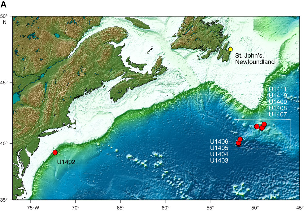
The chosen site was selected in order to collect geological and geochemical data on water structure and flow under the stream of the Deep Western Boundary Current located in the Atlantic Ocean (Figure 1). This mission also aimed to recreate “the Paleogene carbonate compensation depth (CCD)” in the Atlantic Ocean for contrast with newly discovered increased estimates of the carbonate compensation depth in the tropical Pacific (Expedition 342 Scientists, 2012, p.8). Apart from an exceptionally elaborate climate’s past and a thorough evaluation of the structure and movement of such ocean, the last important goal was to retrieve soil segments including well-saved microfossils appropriate for the study of ocean’s historical recreations using mark component and isotope geological chemistry, along with zoological statistics to examine the functioning of ecosystems and transformation on the heated planet Earth.

The Target Locations of Expedition 342
The target locations for the given scientific project are in encrusted movements that may be observed in two specific places: the area of J-Anomaly Ridge and the Newfoundland Ridge. Each of the flows developed adjoining the ocean floors’ upper routes, mainly on the slopes in the northeast and southwest of submarine mountains. Several of such movements are extremely confined structures that generate “lenticular bodies” with the major axis that stretches over deep gradients of more than 1000 m (Expedition 342 Scientists, 2012, p.32). This gave the drifts their distinct shape on seismic data maps (Sexton, Bown, & Liebrand, 2012). Others are surely accretionary structures that already have grown around submarine mountains.
One of the observed spots, a silt ridge, lies between J-Anomaly Ridge and Southeast Newfoundland Ridge, close to Titanic Canyon. According to core samples, the Titanic Canyon slide is wholly composed of silt and was formed as a succession of breakaway hills pressing on the northern slope of J-Anomaly Ridge (Sexton et al., 2012). The data of the geological nature showed that the given ridges seem to be built mostly of mud waves and contain reservoirs of recent, perhaps Pleistocene era silt. Drilling the tectonic drifts, particularly, would be excellent for further expeditions since the sequences allow cores of sedimentation to be deposited at significantly higher rates and offset shallow penetration locations.
Results of Expedition 342
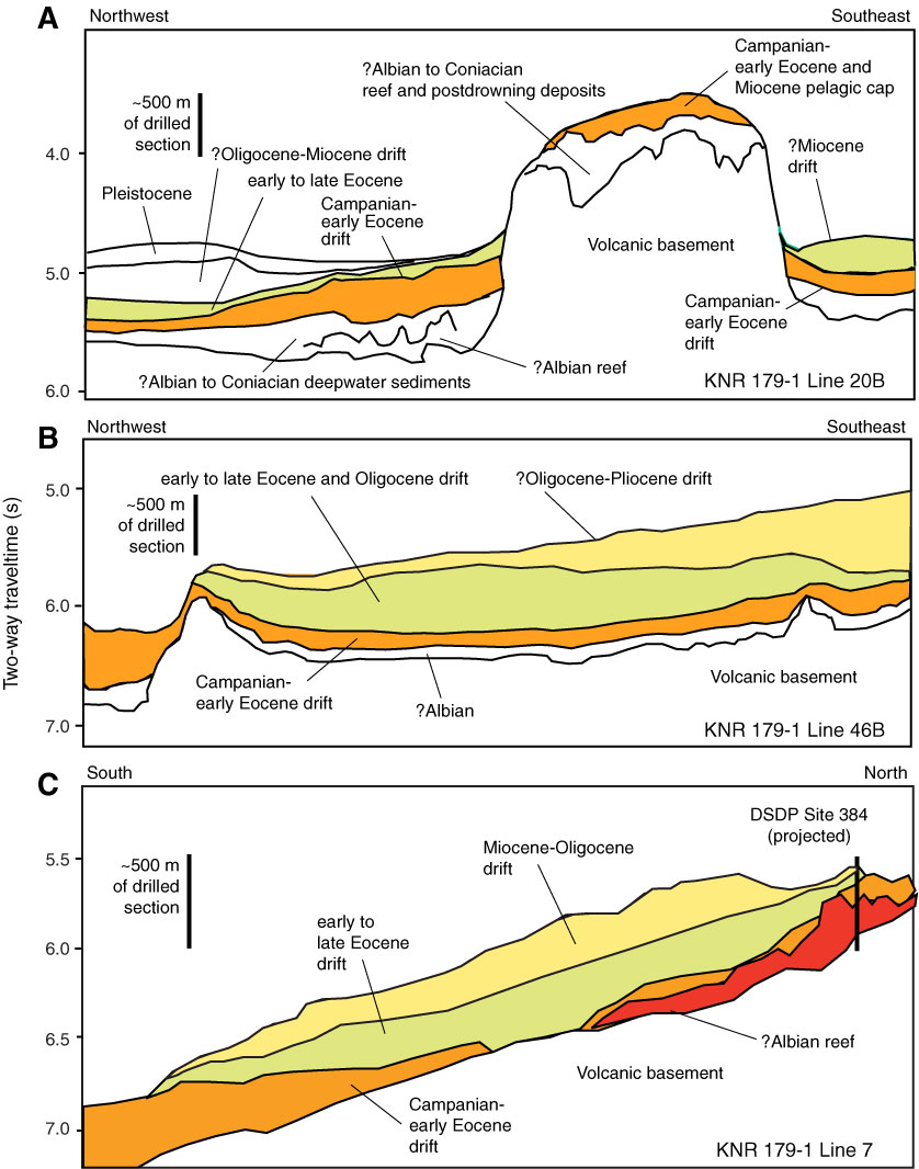
As a result, Expedition 342 carried out four of the drift episodes, each of which was coated by a thin layer of Pleistocene and Pliocene silt, and occasionally Miocene to top Oligocene material. The groundwater locations were drilled on J-Anomaly Ridge, the place where the process met “a carbonate-rich Cretaceous to Paleocene sequence overlain by a clay-rich Eocene to lower Miocene sequence” (Expedition 342 Scientists, 2012, p.32). Further drifts were examined near the peak of Southeast Newfoundland Ridge. Every one of those drifts appears to maintain a succession from the mid-Ecene to the Lower Cretaceous, covering an Albian or earlier barrier structure (Figure 2).

Moreover, drilling at U1407 and U1408 retrieved a large portion of such patterns in one of the given drifts. Drilling inside other drifts, including sites U1409 and U1410, concentrated on the indicator’s earlier, middle Eocene to Paleocene period (Sexton et al., 2012). Lastly, Site U1411 focused on a drift that was confirmed to have a greatly enlarged sequence of the middle Eocene and Oligocene atop an undrilled portion that is presumably of the mid-Eocene period, owing to the fact that seismic links pertain to Site U1410.
The Historical Findings of Expedition 342
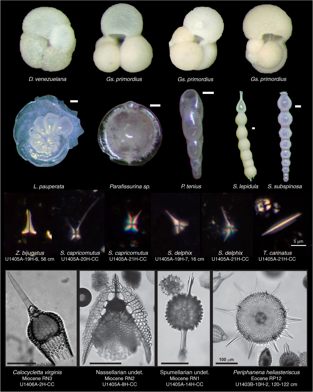
As a consequence, the findings made during Expedition 342 suggest that the commencement of highly clay-rich, fast-accumulating sedimentation. Such sedimentation is usually characterized as the beginning of drift depositing, occurred in the early-mid Eocene across the areas of both J-Anomaly Ridge and Southeast Newfoundland Ridge (Expedition 342 Scientists, 2012) (Figure 3). That conclusion is consistent with current research on the timeframe of drifts initiation in the areas of the northeast Atlantic.

Therefore, the beginning of drift sedimentation to the north and south is estimated to be no later than the mid to late Eocene era. Nevertheless, destruction related to a major “regional unconformity” that formed at the time of the Eocene–Oligocene shift has eliminated material related to early or mid-Eocene drifts all along the American margin in the east (Expedition 342 Scientists, 2012, p.33). The research made great progress by discovering and recovering an enlarged late Eocene segment at various locations maintained in the Newfoundland drift system.
At last, a correlation of the drilling findings with seismographic formations from the Southeast Newfoundland Ridge reveals wide geographical changes in the period and depth of silt drift packages, implying that the region is a potential platform for prospective explorations designed to restore high-deposition rate data from several areas of the Cenozoic. Thus, the research set the foundation for further expeditions of the sediments in the given area.
The Importance of Ocean Drilling
In this regard, such findings are crucial in the understanding of sediments’ age and their belonging to specific eras. As well as putting instruments deep below the Earth’s crust, scientists can sample rocks by drilling in the ocean. Ocean drilling provides scientists with the most reliable data which pertains to Earth cycles, flow, and fluid of seafloor. Through drilling, sediments and rocks beneath the seabed have been recorded and used in studying the Earth’s history and structure (Stein, 2019). Thus, without the utilization of modern technologies and ocean drilling, findings from Expedition 342 could not be recovered. Extensive drilling gives an opportunity to discover older sediments from various eras (Humphris et al., 2011). Thus, the deeper the drilling in the ocean, the older the sediments, which allows us to attain better knowledge of history.
Hence, the primary scientific question which was being addressed in Expedition 342 was the search for sediment drifts, which build at a higher rate than conventional deep-sea soils. The objective was set according to the aim to recreate the past of a heated planet with exceptional precision. The site was chosen on the basis of water structure and flow under the stream of the Deep Western Boundary Current located in the Atlantic Ocean. Subsequently, with the help of the research, we know that the start of drift sedimentation to the north and south is considered to have originated no later than the mid to late Eocene era. The expedition showed that such findings could be provided only by ocean drilling, which aids the determination of sediments’ age.
References
Board, O. S., & National Research Council. (2011). Scientific ocean drilling: accomplishments and challenges. National Academies Press.
Expedition 342 Scientists, 2012. Paleogene Newfoundland sediment drifts. IODP Prel. Rept., 342. Web.
Humphris, S. E., Demenocal, P. B., Edwards, K. J., Fisher, A. T., & Saffer, D. (2011). The need for scientific ocean drilling. Eos, Transactions American Geophysical Union, 92(10), 84-84.
Sexton, P., Bown, P.R., & Liebrand, D. (2013). Expedition 342: Paleogene Newfoundland Sediment Drifts. Integrated Ocean Drilling Program: UK Newsletter, 38, pp. 2–7.
Stein, R. (2019). The late Mesozoic‐Cenozoic Arctic Ocean climate and sea ice history: A challenge for past and future scientific ocean drilling. Paleoceanography and Paleoclimatology, 34(12), 1851-1894.