Introduction
Online web maps provided by different websites have become very popular among travelers, truckers and vacationers. The maps provide a point-to-point instruction for driving and all one has to do is to enter the address of the starting location and the ending location. Once the points are known, then the websites provide a detailed route map of the journey, giving detailed instructions on which road to follow, which roads to avoid, where to turn off and so on. The maps also give the total journey distance along with the estimated time for the journey. This paper uses three websites to plot the journey from, S 17th St & Howard St, Omaha, NE 68102 to Ferry St & S 12th St, Easton, PA 18042.
MapQuest
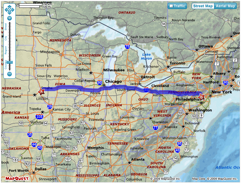
Mapquest is a free online map service provided by AOL and the website provides detailed cartographic information once the starting and ending points of the street addresses are given. A large scale aerial map is first given and then the detailed route is given. To begin the process of planning the route, you need to first enter details in the address from where the journey would begin. Enter the starting point of the journey with the full street address and the city and state name. A pop up is available to help you with the state name. Repeat the same steps and enter information for the end. Once the Direction button is clicked, the full route is mapped out as shown below (MapQuest, 2009).

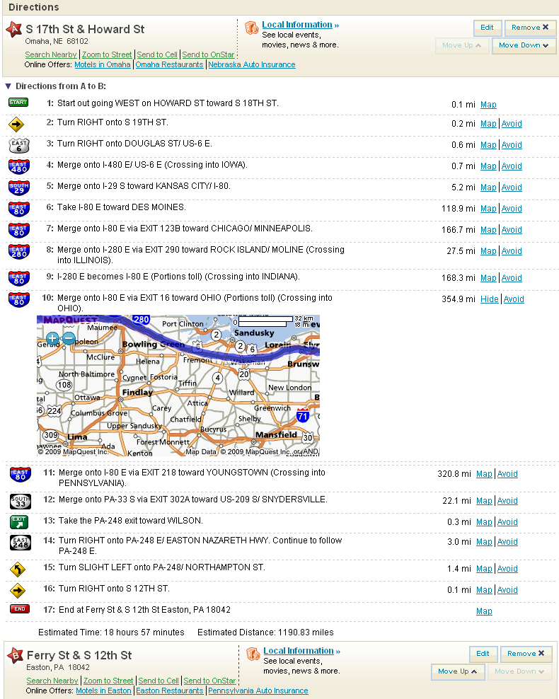
The above map gives the overall view of the route to be followed from point A or the starting point to point B or the ending point. These points are shown as stars. At this point it is possible to select a route with the shortest time or the shortest distance. If the shortest time is selected, then the route that would help the driver to get from point A to Point B in the shortest possible time would be displayed and if the shortest distance is given, then the route with the least distance, but more time, is displayed. The page would also give the directions to get from point A to point B. These direction instructions are as shown in the following figure (MapQuest, 2009).

As seen in the above figure, detailed instructions are given from point A to point B. Since the total time would be 18 hours and 57 minutes, a stopover has been planned Fremont between points 10 and 11 since this point is about 10 hours from the starting point. This would allow the driver to have some rest since it is legally not allowed for a driver to drive continuously for more than 10 hours. If the Chicago point is avoided due to traffic, then the Estimated Distance would be 1250.98 miles and Estimated Time would be 20 hours 11 minutes (MapQuest, 2009).
Rand McNally
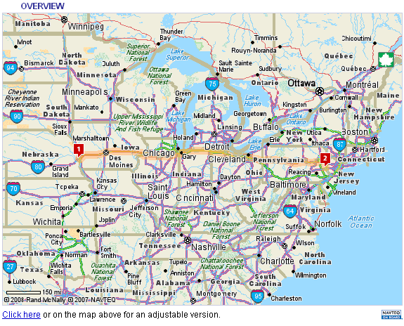
Rand McNally is provides driving instructions along with the route map from the starting to the end of the journey. To begin the process of finding the instructions, you need to enter address of the starting and ending points of the journey. Once these are entered, then click the Get Directions button to bring up the overall route map to be followed, as shown in the following picture (Rand McNally, 2009).

As seen in the above figure, the route map is shown as the dark shaded line.

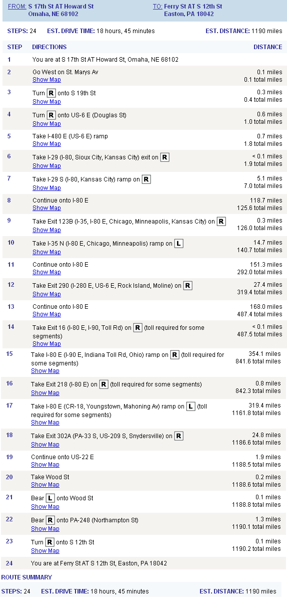
The above figure gives the detailed steps, 24 nos to reach from the start to the end point. It is also possible to find the accumulated points along the route at each step so one knows the distance traveled at any point. The feature helps to arrange for a stopover when the driving time is more than 10 hours continuous driving. Accordingly, a stopover has been planned between steps 14 and 15. The map does not give details of the full between route, only names of the places. It is interesting to note that the breakup of the steps is given in much more detail than MapQuest and this allows very detailed planning of the journey (Rand McNally, 2009).
Google Maps
Google Maps, a division of Google, provides detailed maps of all regions in the world. The website gives very detailed maps and even satellite images of the street address, but the pics are fro m overhead view and users would not be able to relate to them when they are on the ground. To get the directions, you need to enter the street and the full address in the fields labeled as A and B, that are displayed when the Get Direction button is clicked. The detailed map with instructions to get from the start to the end destinations are displayed on the screen. Right side of the screen gives the route map while the left side gives the detailed route and instructions on driving. However, the website tends to be very slow but well worth the wait since it gives details such as hotel names, subways, places of interest along the routes along with their images (Google Maps, 2009).
Comparison of the three sites
It would seem that all the three sites have advantages and some features that others do not. MapQuest provides very good route maps of the required route along with the route directions and steps to be followed. It is also possible to zoom each step and view details of each step and route, view the details of the towns and cities and thus plan for a stopover when required. However, it does not give details such as the cumulative miles at each point and the maps also load very slowly. It also gives information on the traffic and the routes to avoid during seasonal closure. It also has the features of reversing the starting and ending directions and one can edit the route as required. Rand McNally on the other hand allows the calculation of the cumulative distance along with other features. Many of the important features are premium features and available for only paid subscribers and so the casual driver may not make much use of it. Google Maps on the other hand is much more extensive and gives very detailed maps of the route, but detailed planning of the route and journey are not possible. Also the maps in Google take a very long tome to download. It is recommended that MapQuest is best suited for finding the routes and planning the journey. Developers of these sites should provide some information on the site seeing and recreation areas along or off the route so that vacationers can use the info.
References
Google Maps, 2009. Driving Instructions and Maps. Web.
MapQuest, 2009. Driving instructions from Omah to Easton. Web.
Rand McNally, 2009. Driving Instructions and Route Map. Web.