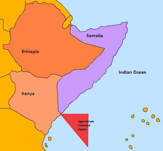
Over the years, the Kenyan- Somalia shores have been a source of controversy. The controversy was initiated by the emergence of pirates who disrupted operations along the Indian Ocean. The Somalia pirates laid ownership claims over the international waters and regularly intercepted sea vessels traversing the vast Indian Ocean. Apparently, the Somalia pirates are considered an important element of the Al Qaeda and al Shabaab terrorists. Another cause of tension between Somalia and Kenya is the discovery of oil and gas on the shores of these international waters. Somalia has moved to the international court with a claim on the shores of Kenya (Mbaria, 2014).
The case presented in the international court has security ramifications for so many countries. However, with the establishment of the UN Convention on Law of the Sea, such conflicts are resolved lawfully. As indicated earlier, conflicts related to international waters have a huge impact on countries depending on the same. For example, the US maritime business is affected, as well as the European and Asian counterparts. Perhaps, this explains the international community’s efforts in eliminating piracy and Islamic radicals in the region. However, such efforts are possible if Kenya respects the international boundaries in the Indian Ocean (Friedman, 2014).
The legal implications about the location of the Manda Naval base arise from the ongoing controversy. Apparently, the Manda Naval base I sued by both Kenya Navy and the United Seas as part of a joint task force mandated with overseeing security in the Indian Ocean. In addition, the legal implications against the ongoing oil exploration by the Unites states companies will cause a complex situation in the future. Already, the United States companies are conducting both offshore and inland gas and oil explorations along Kenyan shores (Ongiri, 2014).
If Somalia wins the case, Kenya will lose about sixty-four thousand square kilometers of the shoreline under oil exploration, including part of the Lamu oil fields. Apparently, the conflict is derived from the interpretation of Somalia Law No. 37 that defines Mogadishu’s continental shelf. From the law, the shelf runs approximately 200 nautical miles. Established in 1972, the law was ratified by the United Nations Convention on the Law of the Sea in 1989 (Mbaria, 2014).
On the other hand, the Kenyan government has taken measures to counter such claims. Apparently, the Kenyan government has used previous agreements between the country and Somalia to prove ownership of the disputed area. For a long time, diplomatic missions between the two countries have had no positive outcome. In fact, the application of the law regarding international waters has not led to any resolution. Interestingly, the Somalia argument is considered legitimate compared to Kenya’s claims (Mbaria, 2014). Kenya should establish a treaty with Somalia regarding the sea boundaries (Mbaria, 2014).
The final option is that Kenya requires compelling evidence about the region’s history. In this regard, the country will have a higher chance of claiming ownership of the area. Apparently, disagreements over resources are a contributing factor to the dispute. The Somalia government believes that the oil exploration blocks are within the country’s boundaries. Therefore, Somalia is entitled to ownership of the oil exploration blocks. As much as the driving forces behind such claims are malicious, they are valid and present the country with the laborious task of proving ownership (Ongiri, 2014).

References
Friedman, A. (2014). Oil & Gas: An Equidistant Line Could Settle Somalia-Kenya Maritime Dispute. Web.
Mbaria, J. (2014). Kenya and Somalia in bitter dispute over Indian Ocean border. The East African, p. 2.
Ongiri,I. (2014). Somalia in maritime boundary row with Kenya. African Review , p. 2.