Abstract
Tornado causes tremendous environmental destruction, loss of lives, and disability. It is described as a fast revolving column of air that spins around a trivial space of extremely low atmospheric pressure with a rotation that touches the ground. Tornadoes being part of the worst occurrences that are always witnessed within the country, the paper explored one of the worst tornadoes to hit the majority regions of the United States on December 16-17, 2019. Emphasis was on the occasions and the destructions caused and the numerous advancements of the tornado. The December 2019 tornado outbreak established the availability of several risk factors within the United States by analyzing the Enhanced Fujita Scale, the atmospheric layers, and the atmospheric variables on those layers. The preliminary severe weather report database demonstrated how useful it is in integrating the atmospheric maps to analyze the events through a synoptic scale. Besides, Obs and Mesoanalysis were used to derive and compare multiple maps with one main variable but this variable has sub-variables such as vorticity and Conservative available of potential energy (CAPE). Based on the analysis done, the synoptic variables indicated their favorability in creating the tornado outbreak in December 2019.
Introduction
Globally, tornadoes are devastating and hazardous as they are capable of causing massive damages. They are associated with adverse weather conditions which result in loss of lives, vegetation, and properties. Despite their occurrence worldwide, the US experiences more tornadoes than any other country (Doswell III et al., 2012). In the US, the economic damages caused by the tornadoes in 2019 were nearly 3.1 billion U.S. dollars (Duffin, 2020). This was the third major economic loss emanating from the effects of tornadoes in the US since the tornadoes of 2011 and 2013 (Duffin, 2020). An updated and insightful analysis is essential in understanding the events around the December 16-17, 2019 outbreak. An evaluation of meteorological synopsis, tornado maps of the various atmospheric layers reveals varied patterns of the wind and its speed, temperature, and jet streams. Besides, the Enhanced Fujita Scale (EF-Scale) is used to describe the intensity of tornadoes by reflecting better investigations of tornado destruction surveys. In this case, the provision of a clear understanding of the omega question and its associated maps is critical in developing future tornado markers and predictor scales.
The tornado occurrence of December 16–17, 2019 was a noteworthy devastating weather activity, which damaged most parts of the US. Distinct supercells formed in the morning hours of December 16 and progressed towards the northeastern parts of the Southern US, producing several robust, long-tracked tornadoes that ended up coagulating into an eastward-stirring storm line. The regions most affected included Louisiana, Mississippi, Alabama, Tennessee, Florida, Virginia, and Georgia. A total of 40 tornadoes were confirmed with the maximum EF rating of EF3. The highest wind speed recorded was 158mph with the largest hail of 1.75in (44 mm). During the disaster, the US National Weather Service (NWS) issued several Particularly Dangerous Situation (PDS) tornado forewarnings with an occasional tornado emergency for Alexandria.
Meteorological Analysis
The principal signs of adverse weather activity started on December 12, with the SPC drawing a day 5 risk zone traversing parts of the Mid-South and lower Ohio River Valley. The effect was a 15% delineation area, which shifted southwestward on December 13 and transformed to a comprehensive Slight risk for destructive weather on December 14. In the subsequent days, the SPC offered an Enhanced risk through portions of Louisiana, Mississippi, and parts of eastern Alabama. Close to noon of December 16, a Moderate risk region was presented from Louisiana across central Mississippi.
Anticipations of a tornado occurrence ascended on December 16 as a fine outlined, completely-slanting channel, which occurred through the central US, and a very sturdy cyclonic current established itself along its southeast part. At the crest, a cold front of air was estimated to evolve across the Southeast US while an escalating area of low atmospheric pressure proliferated northeast alongside the frontier. The background across and front of this anterior was expected to be useful for studying hazardous weather signaling, highlighting dew points elevated as the low 21 Degree Celsius, with 500mb Convective Available Potential Energy (CAPE) in the order of 1,000–2,000 J/kg. In the late afternoon, a stable signal for constant warm-sector supercells emanating from the existing model guidance indicated reliability to possible manifold substantial tornadoes (León-Cruz, Carbajal, & Pineda-Martínez, 2017). The SPC delivered their first warning for a tornado, the first amongst four during the day as the adverse weather condition risk spread eastward. Soon after, discrete supercells settled within the warm sector through southern Louisiana, while a streak of storms thickened within the abnormally advancing cold front.

The Enhanced Fujita Scale
The EF-Scale ranks the strength of tornadoes. The countries experiencing frequent tornadoes include the US and Canada. The measure has the same basic plan as the former Fujita scale with six strength classifications ranging between 0-5, signifying cumulative rates of impairment (Doswell III, et al., 2009). It reveals improved inspections of tornado injury surveys, to arrange the wind speeds concerning their allied storm impairment. Besides, it also enhances more types of structures and environmental flora by intensifying degrees of injury and enhancing explanations for variables such as alterations in erection value. Another type of EF-Scale known as “EF-Unknown” (EFU) was added to the scale to reflect the tornadoes whose destructions are yet to be identified.
Table 1. Indicates the EF-Scale rating and corresponding degrees of damage.
The exploration of the diverse atmospheric conditions in the event of the Tornado Outbreaks of December 16 and 17 in 2010 can provide support in explaining the climatic activities. In the event of weather changes, there is a modification of the atmospheric layers to generate hazardous conditions of tornado outbreaks. Therefore, it is important to evaluate the meteorological maps of the various atmospheric layers to reveal sundry patterns of the wind, its speed, atmospheric temperatures, and the jet stream.
Synoptic Upper Air Analysis
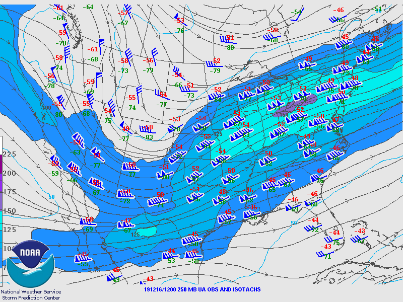
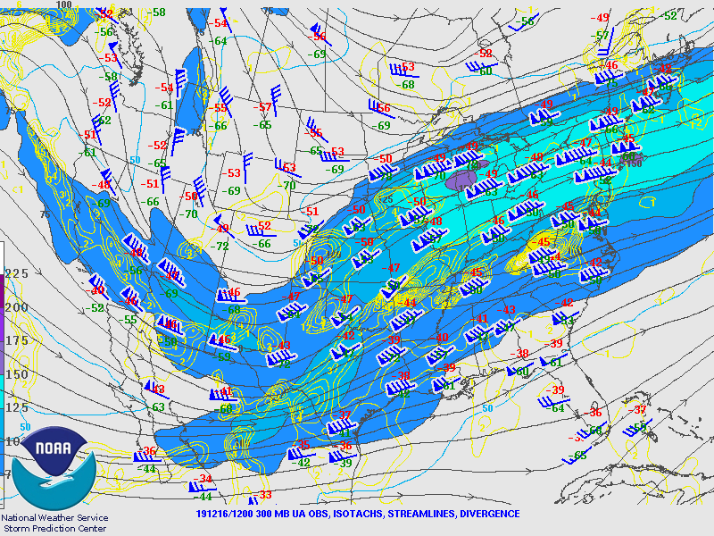

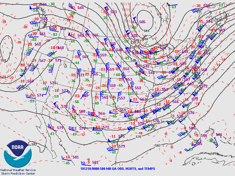
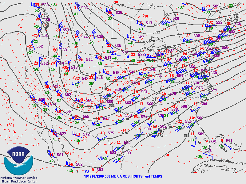
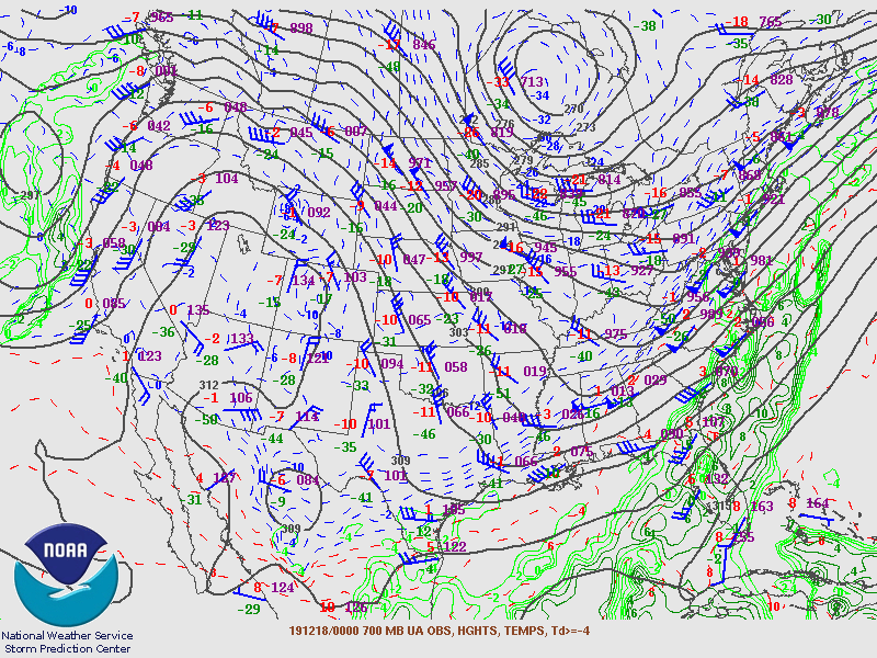
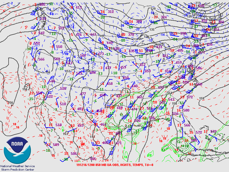
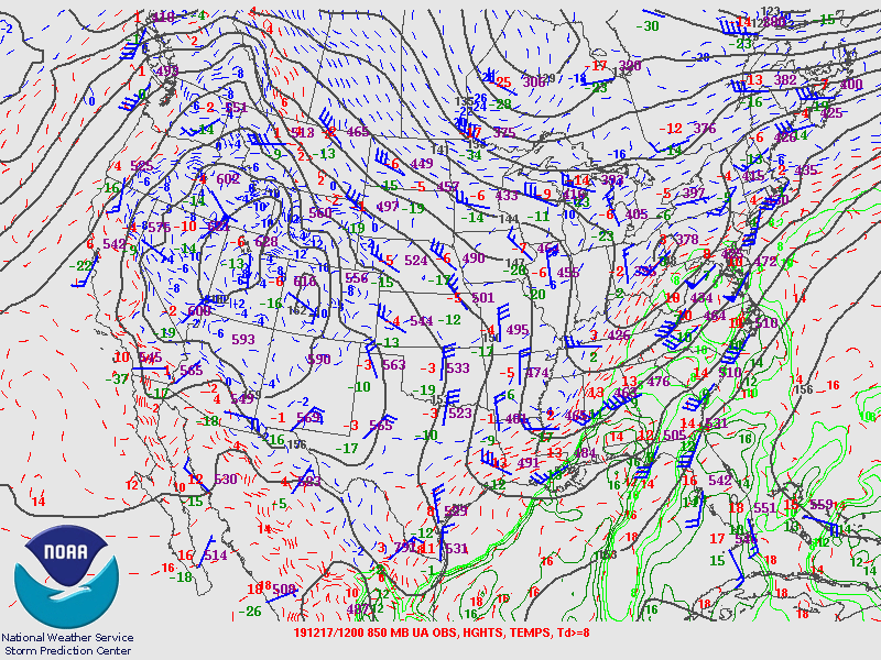
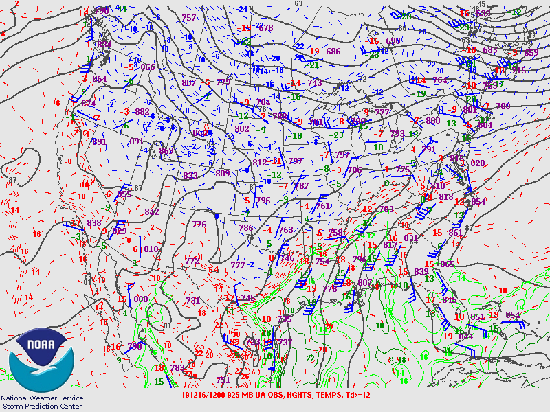
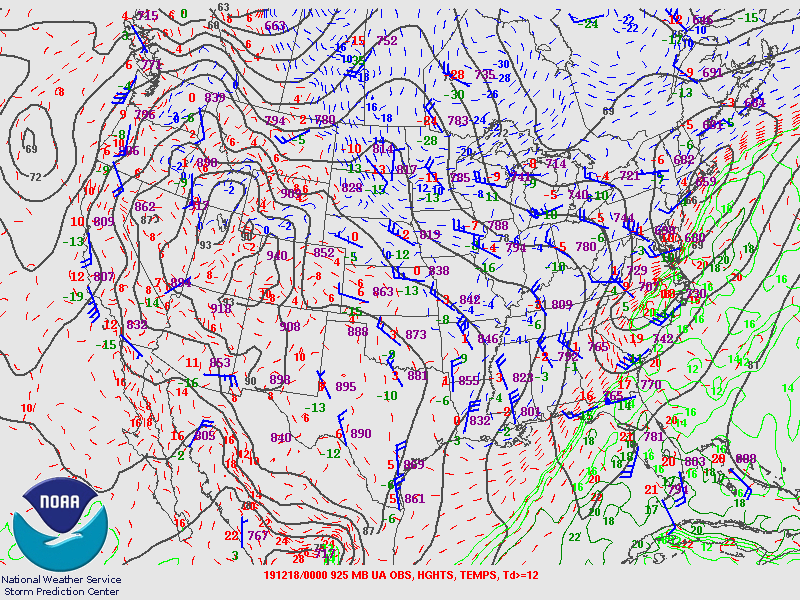
Figure 2 shows that at 250mb, the wind and the location of the incident of the tornado outbreak were aided by a predominant jet streak. It indicated an upper level that strengthened strong wind shear development in the company of the imposing unpredictability at the atmospheric layer and it keeps developing along the convergence area as shown in Figure 4 and Figure 5 (Davis & Walker, 1992). Figure 2 and Figure 6 demonstrate synoptic upper air analysis of 250-500mb pressure levels on December 16, 2019, at noon UTC, respectively. The anterior system is compelled by a cold volume of air touching southward from higher latitudes with mid-atmospheric levels at 500 hPa (Figure 6). This volume of air converges with a warmer humid air flux from the Gulf of Mexico at low levels producing high perpendicular winds shear in the obverse edge (Figure 7). The air masses with diverse converging qualities have been described as key features in causing destructive storms with a high probability of tornado formation.
The cold volume of air moving from the mountainous zones in the northwest of the US creates high steep lapse rates, concomitant with the formation of tornadic supercells. Notably, the development of the tornado outbreak is supported by a mid-latitude cyclone that was powerful together with an intense shortwave trough at the upper level (Pfeiffer, 2001). Intense, strong heat along with moisture advection was rising to the period that the tornadoes were taking place. More so, the layer indicated two shortwave troughs negatively tilted at the upper level over the western SE, and behind the big trough, which is fixed in the longwave trough at the high level positioned over the central part of the US. This system revealed a potential jet streak at the mid-level of 150+ knots with extreme winds linked to the jet streak at the upper levels. In such a case, the conditions indicated severe weather at the level of the surface.
Figure 4 indicates that the conditions of the weather were even worse at the 300 mb atmospheric layer (NWS Storm Prediction Center, n.d). Despite the flow of the winds being less as shown by the wind bars in comparison to the 250mb (Figure 3), there were well noticeable jet streams, troughs, and ridges in the areas. Jet streams usually energize the troughs as well as the ridges to worsen the conditions of the weather even further. The alterations in the temperature lead to the expansion of capes that are crucial for tornado outbreaks in the upper atmosphere. Besides, the geostrophic divergence at the atmospheric layer was a dynamic forcing mechanism pivotal for the atmospheric explosion.
At 500mb atmospheric layer and isotherm, similar conditions were seen. However, the strength of the wind was reduced as shown in Figure 4. It indicates that the winds had 20 knots as the average speed. In this case, the troughs were larger converging at the center. Large channels usually have lesser wind speed in comparison to shortwave troughs. Generally, the convergence results in a ground force that aids the lifting of the air. Similar conditions led to the diverse vorticities in the area. The airspeed variations lead to negative and positive vorticities in the various regions (Moore & Lambert, 1993). Figure 10 is best used to show differential vorticity advection. The map represents positive vorticity advection (PVA) and negative vorticity advection (NVA). The PVA is more dominant than NVA with this system. This means there is more upward vertical motion with this system and spinning up.
The shortwave trough at the mid-level was most pronounced as shown in Figures 8 and 10 (Storm Prediction Center). By the 700mb shortwave, there was a weak yet cyclonically low-pressure that was organized at the surface. The manifestation of the instability was at the surface-based values of the CAPE of 3,000 J/kg+. Further, a low-level veered hodograph with bulk shear values of 0 to 6 km that was 33kts, as well as helicity values of 0 to 3 km approached the 267m2/s2 was adequate for the production of supercells.
The instability potential to heighten as a result of a dry and mid-level atmosphere that surrounded the 700mb (Oltmer, 2009).In Figure 9, the vertical velocity is essentially showing where the air is rising and sinking. The upward motion of air has a positive velocity and the negative velocity is the downward motion of air (Moore & Lambert, 1993). Moreover, winds were veering around 30 degrees between the surface and 700 mb. In this event, as it is shown from the vertical velocity maps, it shows high positive vertical motion which indicates positive vorticity advection and which is a forcing mechanism to help create the rotation for tornadoes (Moore & Lambert, 1993). Figure 9 indicates the 700 mb and relative humidity.
Figure 10 and Figure 11 indicate the 850mb geopotential height field as well as the 850mb isotherm and wind vector. The warmer along with the low-level air that is moister, the increasing atmosphere that is unstable is because of the air that is saturated. In addition, there is the maximization of the latent heat that is released, which maintains a warmer air parcel in comparison to its environment for a long time (Song et al., 2007). The differences in the pressure are responsible for the wind together with the temperature advection in that layer. Besides, the center had a lower pressure in comparison to the other regions. The center had a low pressure of 320 on December 16 and it kept around this value for entire the event with a decreased temperature of 2 degrees as indicated by Figure 12 and Figure 13 (NWS Storm Prediction Center, n.d ). Moreover, in Figure 13 the maps of SLP, Low pressure, and High pressure with the fronts indicate what is expected in severe weather. Besides, both figures represent surface conditions. The low-pressure kind to be stationary and it signed as a strong low with a value of 996 mb.
Also, the surface map indicates that the backing surface wind and the upper jet stream at 250 mb played a significant role to conduct and create tornadoes over the area. Moreover, Theta-W in Figure 13 represents the instability weather in the region. Since increasing Theta-W is a result of increasing temperatures and/or moisture, the instability also increases. The last two days show an increase in Theta-W along with great Plan to South Part of US which burse the convective activity and tornados as well. The phase lag Figure 13 shows the thickness between 100-500 mb and 500 mb height. It gives in phase lagging in both troughs of height and isotherm but there is out of phase in the last day at the ridge and out of phase in the trough between December 16 and December 17, which explains the sudden change in the number of tornadoes over that area.
The skew T diagram
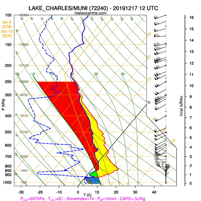
The skew T diagram designates the fluctuations in the temperature and the wind. As shown by Figure 13, the changes in the pressure along with the temperature resulted in the formation of wind shear causing the meeting of the cold and the warm air flows. Most times, the wind shear leads to the deterioration of the weather conditions to cultivate tornadoes outbreaks. Thus, there were ideal conditions for the occurrence of a tornado outbreak by the changes in the pressure and temperature.
The Omega Equation and Differential Vorticity Advection
The following points describe parts of an omega question that describes the rate of change of atmospheric pressure over time.
It gives the first term A: 3-D Laplacian of omega. On the right-hand side, the first term is in place of differential vorticity advection (DVA) which indicates the upward signal. The upward motion is evaluated when incorporating the advection vorticity at between 1000 and 500 mb. If term A > 0 downstream of the 500mb trough located upstream surface cyclone, we can see that vorticity 700 mb increases absolutely at low levels on the surface. On term B: (DVA) that states the upward motion is associated with vorticity advection increasing with heights and the Laplacian of advection of temperature by the geostrophic wind. This term is estimated at 700 mb. A region of maximum warm air advection (term B > 0) is linked with forcing for ascent at 700 mb. An area of maximum cold air advection (term B < 0) is characterized by pushing for descent at 700 mb.
Term A and C annulled each other since they both have the Laplacian operator. Therefore, it is possible to analyze the (DVA) maps in Figure 9. The vorticity is taken in 500 mb with plug color and it is vibrant with a magnitude of the vorticity. In the same map, the (DVA) is shown in 700 – 250 mb which is represented by the blue counter. Conversely, the worm advection areas which are in maps with the red color represent an upward drive. In such adverse weather, the DVA is usually the most crucial stage that can be observed.
Additionally, there is another form of vorticity advection that might be taken known as potential vorticity (PV). While the DVA is observed on one layer of atmosphere as in the same Figure 9 in 500 mb, the likely vorticity advection is enclosed between two isentropic surfaces. It could be displayed on any other cover, but if its potential vorticity is located on a surface with constant possible temperature, and then it is known as isentropic likely vorticity advection (ILVA). In Figure 9 on the right-hand side, the PVA is displayed between 400- 250 mb, and it is clear that the location of PV is the same as DVA with high positive values.
Overall, the increase in differential vorticity and PVA indicate such severe weather on the surface as it happened on December 16-17, 2019. High cape areas are associated with enough moisture in the air. Tornadoes can be formed when several thunderstorms occur in areas of unstable air when winds change direction or speed with a height that is the primary ingredient for tornado formation. When warm air rises over the mountain to the peak, it loses moisture on the leeward side. The pressure differences and when the cold air and warm air crush support tornado formation. It is worth mentioning that the Most Unstable cape is used to determine and forecast severe weather like thunderstorms and tornadoes when a low-level inversion might be present in the region. It also is useful to forecast thunderstorm which occurs out ahead of the worm front with the same place of low-level inversion.
Conclusion
A simplified and insightful analysis of the December 16-17, 2019 has been described to offer a clear understanding of the events leading to and the aftermath of the outbreak. Meteorological synopsis, tornado maps of the various atmospheric layers has also been demonstrated to reveal varied patterns of the wind and its speed, temperature, and the jet stream. Besides, EF-Scale that reflects the intensity of tornadoes has been described to improve the investigations of future tornadoes, thus arranging winds more closely than closely with related storm damage. In this case, the provision of a clear understanding of the omega question and its associated maps has been demonstrated to be critical in developing future tornado markers and predictor scales.
References
Ahrens, C. Donald. (1998). Tornadoes essentials of meteorology: An invitation to the atmosphere (6th ed). Wadsworth Pub. Co.
Davis, R. E., & Walker, D. R. (1992). An upper-air synoptic climatology of the western United States. Journal of Climate, 5(12), 1449-1467.
Doswell III, C. A., Brooks, H. E., & Dotzek, N. (2009). On the implementation of the enhanced Fujita scale in the USA. Atmospheric Research, 93(1-3), 554-563.
Doswell III, C. A., Carbin, G. W., & Brooks, H. E. (2012). The tornadoes of spring 2011 in the USA: An historical perspective. Weather, 67(4), 88-94.
Duffin E. (2020). Economic damage caused by tornadoes in the U.S. 2019. Statista. Web.
León-Cruz, J. F., Carbajal, N., & Pineda-Martínez, L. F. (2017). Meteorological analysis of the tornado in Ciudad Acuña, Coahuila State, Mexico, on May 25, 2015. Natural Hazards, 89(1), 423-439.
Moore, J., & Lambert, T. (1993). The use of equivalent potential vorticity to diagnose regions of conditional symmetric instability.Weather And Forecasting, 8(3), 301-308. Web.
NOAA’S National Weather Service. (n.d.).SPC severe weather event review for Monday December 16, 2019. NOAA/NWS Storm Prediction Center. Web.
NOAA’S National Weather Service. (n.d.). SPC severe weather event review for Monday December 16, 2019. NOAA/NWS Storm Prediction Center. Web.
Oltmer, D. A. (2009). The Use of conditional and potential instability axes for severe weather forecasting. Naval Postgraduate School Monterey Ca.
Pagé C. (2019).Radiosonde / United States / Lake_Charles/Muni (72240)-20191216 00 UTC. UQAM/Mateocentre.com. Web.
Pfeiffer, K. D. (2001). The mesoscale evolution of explosive cyclogenesis: A numerical study of the March 1993 storm of the century. North Carolina State Univ At Raleigh.
Song, G., Yan, H., Yang, S., & Li, W. (2007). Investigation on evolutive laws of geopotential Height of two poles and the equator at 500hpa geopotential height field.Chinese Journal Of Geophysics, 50(1), 58-66. Web.