Introduction
While in reality, the existence of agglomerations near the shores of the sea or ocean bays seems most comfortable and attractive in environmental and climatic terms. Such life can be complicated by several negative factors related to the lack of local natural disaster management. To put it another way, densely populated locations with grandiose population density, additionally attracting tourist flows every year, have the potential to lead to emergencies with threats to the life and safety of the population. In this connection, an in-depth study of existing mechanisms of counteraction to coastal disasters provoked, among others, by abnormal climatic fluctuations is an expedient solution.
The central topic of this work is geographic-ecological research of the coastal zone of the USA, namely one of the most populated cities of the state, San Francisco, California. The population of this region, according to official data, exceeds 800,000 people, with the city being a traditional travel destination for citizens from around the world (Brinklow, 2017). However, the agglomeration’s climate is classically Mediterranean with warm winters and dry summers, the factors of global climate warming place San Francisco under numerous threats. This paper seeks to critically assess the problems associated with the chosen area, along with reflections on possible methods of controlling critical situations.
Geographic Features of the Region
San Francisco is located at the tip of the peninsula of the same name on North America’s west coast. It is noteworthy that although the total area of the city exceeds 600 square kilometers, of which about 120 is occupied by land, the boundaries of the territory are highly blurred along the Pacific Ocean coastline. In general, it is worth recognizing that of the four possible sides, San Francisco is surrounded by water from three: its land is washed by the waters of the Pacific Ocean and the bay of the same name.

In the context of lithospheric and landscape structure, it should be noted that the proximity to the ocean has made the city’s topography hilly and uneven. A closer examination of why the hills in San Francisco are so varied — there are more than forty in the region — reveals that near the geographic center of the city, there is a junction of two lithospheric plates, which find themselves in constant motion relative to each other (“Discover,” 2018). The collision and friction of such giant tectonic objects cause not only regular coastal earthquakes but also fracture formation.
The city’s urban landscape continues to change as the population expands, and the agglomeration becomes more attractive to residents. In particular, several new neighborhoods have been built using artificial infill water technology. Summers are quite warm, so locals prefer to spend time on the city beaches: broad sandy areas are significant for refreshment, as a cool breeze blows uninterruptedly from the Pacific Ocean.
Human Characteristics
San Francisco’s population continues to grow because of the region’s many spectacular advantages: climate, infrastructure, economic patterns, and culture. According to Brinklow (2017), the region’s population density is relatively high, at 7,120 people per square kilometer. Geographically, the city is developing, occupying new areas along the coast and creating artificial islands. Economically, the agglomeration continues to expand thanks to tourism, high-tech industries, and the financial sector.
Climatic Conditions
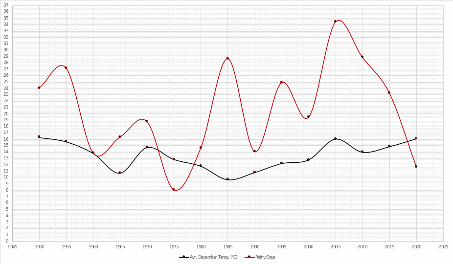
At just above sea level, San Francisco has a climate with characteristics similar to those of the Mediterranean. Local winters are much colder than summers, but temperatures rarely drop below seven °C, while summer temperatures are low, with temperatures in August and September hovering around 20-21°C (“Monthly,” 2020). The region has many different microclimates, but rainfall is generally infrequent, with most rainfall occurring between November and March. The number of rainy days annually fluctuates around the seventy-day mark. This was not always the case, though: for easy visualization of historical meteorological information, some of the most critical parameters over the past seventy years are presented in the table below (“San Francisco,” 2020; “Climate,” 2018). As it can be seen from the data, San Francisco has long been characterized by periodic fluctuations in climatic conditions.
Climate Disasters
It must be recognized that San Francisco’s main advantage, its proximity to the ocean line, is also an important problem for the city’s civil safety. Tectonic movements are natural causes of earthquakes, with one of the most significant occurring in 1906. At that time, the strike’s magnitude was 7.8, killing several thousand people and destroying about 80% of the buildings (Garr, 2016). Thus, earthquakes are frequent here, and there is more than a 50% chance of another major earthquake within the next thirty years (USDI, 2016). For instance, tectonic plate movements are known to cause shifts in ocean currents, which in turn cause climate change.
It is worth recognizing that tsunamis are not a frequent occurrence for San Francisco, but the last known episode occurred in 2011 due to a powerful earthquake in Japan (“How vulnerable,” 2019). At the time, the city’s infrastructure was damaged, highways flooded, and dozens of lives were lost.
Finally, severe storms formed over the ocean can cause significant flooding of areas. Landmark episodes have been seen in the city’s history: in 1986, a powerful storm dumped about 50 inches of rain in San Francisco (Barber, 2017). In 1996, warm rains caused hilly glaciers to melt, causing flooding on the city’s east side: rainfall levels then exceeded the 24-inch mark. Similar disasters were observed in 2005 and 2006 when uncontrolled rains flooded the city’s infrastructure.
The Possible Effect of a Warming Climate
There is no doubt that the planet is in an era of global climate warming, the effects of which will be noticeable in all areas of life. In San Francisco, as one of the coastal cities, the changes will be most noticeable. Climate change will intensify the frequency of flooding in the city as rainfall will naturally increase. The vulnerable resident population is projected to increase by 20 percent by 2050 (“California,” 2019).
In turn, rising water levels will intensify erosion and erosion of road surfaces, causing the destruction of residential riparian areas. This means that the city will gradually become more and more flooded, which means that we can expect it to disappear altogether in the future. It is fair to say, however, that the economic side of the agglomeration is also subject to severe risks. Because of the threat of sinking homes, the investment appeal of San Francisco is severely diminished, and consequently, less money is flowing into the region.

Responses
It would be a mistake to blame San Francisco authorities for inaction in fighting natural disasters since the relevant departments develop profile plans and conduct detailed analyses of changing climate conditions. Thus, by researching and predicting a potential problem in advance, SF DEM can implement the necessary solution to reduce an accident’s economic and material damages. However, if a problem has already occurred, the department launches an ambitious plan to evacuate the population, stop the cause of the biogenic disaster (if possible) and restore urban supplies. Specific policies include staged situation management, FEMA, combined with prioritizing recovery and support goals after a disaster, RSF (“Recovery,” 2018).
Moreover, SF DEM actively invests in developing natural disaster prevention and management programs, creating integrations with popular social resources (Fracassa, 2019). Thus, it is evident that the department not only maintains a rigorous organizational and preventive program to monitor and manage accidents but also an informational program to alert people.
However, it may seem that existing programs and technology do not maximize efficiency because San Francisco experiences the same power and water problems every time there is an earthquake, landslide, flood, or storm. Hence, some recommendations seem appropriate to put into practice for the city. First and foremost, it is worth building some visually appealing dams and reservoirs to deal with excess water during crises effectively. It is essential to ensure that the city has a ban on housing in vulnerable areas and existing settlements are moved outside the danger line. In addition, building levees along the shoreline will delay flooding in the city, as will widening and cleaning up existing rivers.
The broader and fuller the rivers are, the more likely they will carry more water in times of flooding. Finally, the construction of bypasses around the regions, as is typical of Venice, will allow excess water to drain away from the protected area and give the city’s architecture a fresh and natural feel.
References
Barber, M. (2017). 4 historic California storms that caused serious destruction. CurBed. Web.
Brinklow, A. (2017). Mapping what SF would be like if it were as dense as New York, Paris, and Manila. CurBed. Web.
California coastal flooding. (2019). States at Risk. Web.
Climate of San Francisco. (2018). GSWS. Web.
Discover the 7 hills of San Francisco. (2018). Stanford. Web.
Fracassa, D. (2019). SF planning big disaster-preparedness bond for next year’sm ballot. SFC. Web.
Garr, S. (2016). The 5 most horrific tragedies and natural disasters in San Francisco’s history. Only in Your State. Web.
How vulnerable is California to tsunamis? (2019). CBS8. Web.
Monthly weather forecast and climate San Francisco, CA. (2020). Weather Atlas. Web.
San Francisco, CA weather history. (2020). Weather Underground. Web.
Recovery plan. (2018). ONESF. Web.
USDI. (2016). Earthquake outlook for the San Francisco bay region 2014–2043. Web.