Conceptual Model of a Site which Illustrates the Potential Sources of Contamination, Potential Migration Pathways and Possible Receptors Vulnerable to the Contamination
Conceptual Site Models (or CSMs) constitute an aspect of objective processes which are data-quality based and relevant to site-activities involving the collection of information on the environment (EPA 2006). Based on the fact that the destination of transported contaminant sedimentation is usually complex and reliant on physical or chemical properties of transported materials, the water-body (which may be affluent or influent and directly affected by sediments or deposits) makes it absolutely necessary for ensuring a detail as well as complete CSM.
Naturally, there is a development of two (2) sorts of CSMS when investigating and remediating a site. One of the developments expresses the hydro-geological condition of the investigated area’s construct and shows the drift-tendency of the contaminants as well as emphasizes the transportation (this infers a clear illustration of contaminants’ present position, biological/geochemical changes, as well as the final destination of the contaminants). The information is exceedingly appropriate for generating CSMs which tackle feasible risks from sites on humans as well as on ecosystems. In this regard, it is necessary for the CSM to address ongoing geochemical/biological activities in the sedimentation’s transitional zone.
A transitional zone is ordinarily an influent water body that constitutes areas dominant of Groundwater, mixed Surface and Groundwater, and then Surface-water (EPA, 2008). It has been noted:
‘The transition zone is an ecologically active area beneath the sediment/water interface where a variety of important ecological and physicochemical conditions and processes may occur’ (EPA, 2008).
The encapsulated site history between 1910 and 1953 as illustrated in Figures 3 to 5 from the question provides a glimpse of information that is relevant for tracking the transition zone and for an effective CSM construction. It has been mentioned that the reservoirs in the site could date back to the later years of the 1800s and that they were structured for clean water supply. The present tipped area is the 1940s dated by estimation and while there is no properly defined proof of the existence of any structural buildings on the said site, there is evidence of industrial-based functions on the site from the north which included textile works.
There is also the Drift geology illustrated in Figure 7 (from the question) and the underlying rock, known as the Solid geology, in Figure 8. Map indication regarding the site and the permeability data recognize the closeness of the site to geological boundaries in the rock and the drift. The site is noted to be underlain by a Glacial Drift; characterized by highly unyielding clay which comprises sandy lenses as well as sporadically by cobbles. In any case, it has been stressed that the Glacial Drift could be eroded by River Irk, which has consequently deposited alluvium in the erosion feature.
It is extremely necessary to regard the data from the question in the determination of risks and levels of the cleanup in the CSM. Thus, the Conceptual Site Model has to address complex and uncertain issues in the data regarding the transitional zone. In a related study, it was identified that
‘a tetrachloroethene (PCE) groundwater plume changed its size, shape, and composition as it passed through the transition zone’ Conant et al. (2004).
From the study, the occurring biodegradation on the uppermost 5 meters of the considered transitional zone brought about a reduction in the level of concentration of the PCE; however, it brought about the creation of highly concentrated varying transformational products and hence uttered the plume’s toxicity. Therefore:
‘The biodegradation was spatially variable and concentrations in the streambed varied by a factor of 1 to 5000 over distances of less than 4 meters horizontally and 2 meters vertically’ (EPA 2008).
Illustrated in the following figures is a significant consideration of the certainty of results of contaminations; which encompass presently occurring activities, historic activities – or is a combination of the two; which identify the flowing path of ground-water into apparently consistent sedimentary beds and is made complex due to the geology of underlying aquifers; and then, conclusively the utility of designed remediation of CSM for the identification of possible faults.
Figure 1 presents a number of probable bases for the contamination of the sediments which could be resultant from the following enumerated processes:
- surface run-off from up-land point sources;
- discharging impure groundwater;
- directly discharged non-aqueous phased liquids;
- air contaminant depositions; as well as
- impure sediments’ conveyed from up-stream point-sources.
It is a usual recognition not to remediate sediments as stated:
‘…until all sources have been identified and eliminated so that they can no longer contaminate the sediments’ (McGrath and Loveland, 1992).
Figure 1 illustrates that sources of the contamination could be present ones (such as dynamic contaminated ground-water advection into sediments) and could as well be historical (such as the 1940s discharge of textile products from manufacture processes and from storage-facilities without present emergent discharges from upland – in this instance from River Irk).
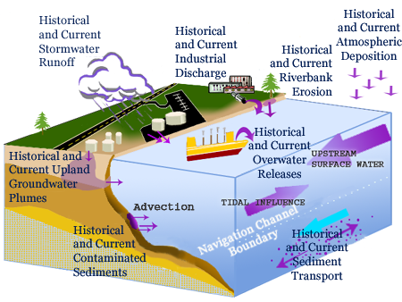
In the course of the CSM development, there is the verification of suppositions. As an illustration, taking cognizance of the clean-up of textile-waste contaminated-sediments, emphatic studies on Ashtabula-River where an exacting underlying initial-assumption was presumed about PCBs’ discharge historically; and it was noted that:
‘at a time that baseline-samplings were carried-out preceding the start of the dredging process, a dynamic basis a certain portion of the river’s tributaries was noted’ (Cieniawski, 2008).
Considering that the source referred by Cieniawski (2008) was never revealed and gotten rid of, the costly remediation would have ultimately been botched.
Figure 2 illustrates an anticipated interrelationship between ground-water and surface-water; the knowledge which is essential for conducting successful remedies of the sites. There is then a patterned illustration of the ground-water from and into River Irk with a selected pathway for ground-water to surface-water discharge. Assumptions regarding the possibility of diffusion and uniformity of the discharged contaminated water across the sediment bed could bring about erratic risk estimation or a possible inappropriate designed cap. For producing a correct Conceptual Site Model, it is necessary therefore to have an appropriately defined pathway of flow (EPA 2008 could be consulted for thorough discussions). The study area could constitute influential as well as affluent sections. Perhaps, with no upland sources of contaminated groundwater, studies have stated that:
‘capping the contaminated sediment could still allow surface water to flow through it, thus contaminating the underlying groundwater’ (Cieniawski, 2008).
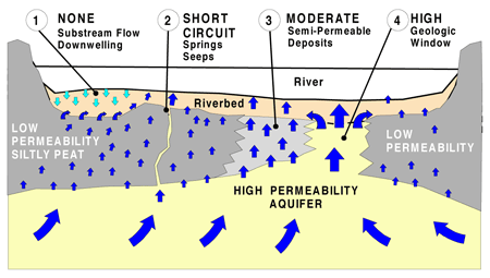
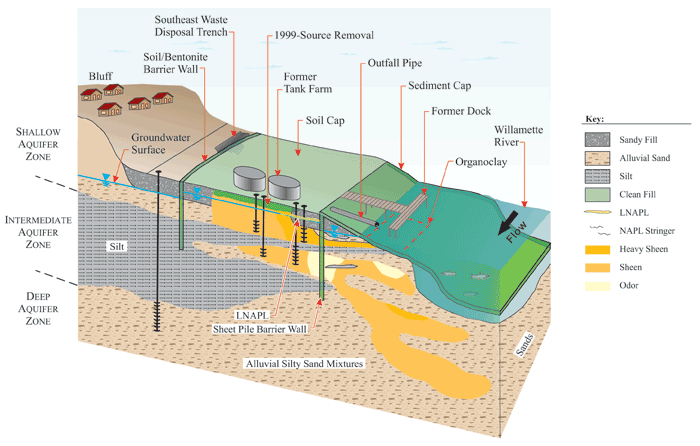
Figure 3 shows a well-defined patterned Conceptual Site Model of preferred site remedy. The flow of the sediment-contaminant source all the way through the surfaces should be noted as it is hindered by shoreline barrier walls. The caps make use of Organoclay in adsorbing NAPLs as well as the contaminating constituent in the ground-water which at the instance is in the aquifer beneath River Irk and would be discharged about the sediment-bed to the caps. The barrier walls should be appropriately deepened in order to prohibit contaminations from under-flowing otherwise there would be an incidental collapse of the cap material. In case barrier walls are made use of for upland containments, the strength of the material should be taken cognizance of. Assuming that a sheet-pile wall is to be used, it should be noted that the material could easily yield under the application of load. In the same way, slurry-wall constitutes non-uniformity placement hence there is a tendency for contaminants to diffuse across slurry material.
A general outlook of a Conceptual Site Model is then presented in Figure 4.
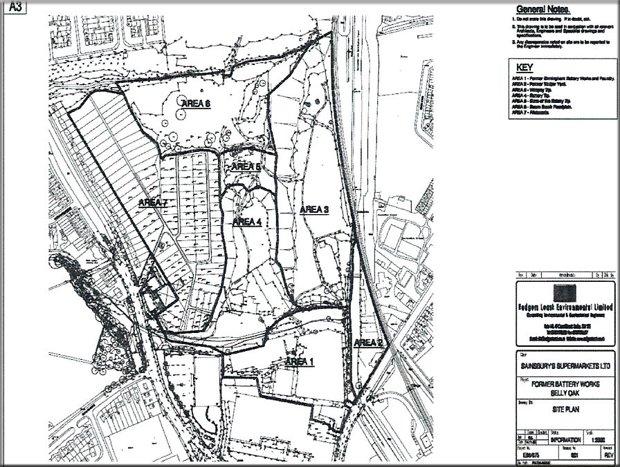
From figure 4, the general outlook of the CSM is presented and segmented into six (6) areas for the disposal of varying wastes- this is necessary in order to mitigate the effect of toxic waste (or to control the general flow of contaminated substances in the site). Toward River Irk, it would be preferable to dispose of waste that may not be affected by the effluent or influent flow of the river. From figure 1, the possible receptors vulnerable to the contamination would include downstream occupants especially at Harphurhey Road, hendham Vale and likely Kingsbridge road- and this would be resultant of the effluent effect of River Irk.
Site Investigation Strategy
The requirement at this instance is to develop a site investigation strategy in order to achieve the following objectives:
- To assess the risk from the waste to the receptors identified in the model;
- To characterize the contamination conditions at all contamination resources;
- To establish background contamination conditions (i.e. contaminant concentrations which would exist in the environment if the waste was not present); and
- To investigate any assumptions included in the Conceptual Site Model, for example, the groundwater depth, the contaminant migration direction, the relationships between the different geological units.
The Quantified Risk Assessment (QRA) would be adopted for the investigation of the CSM under consideration. Even though there is a limitation to applying QRA modeling to POP problems, the method leads more focally to the realization of standard risk assessment making use of Source-Pathway-Receptor circumstances. Individual sites have peculiar instances which are considered in observing the scenario for modeling. In other to assess the CSM appropriately, there is the need for sectionalized construction of the site with consideration to interactive sources including receptors on properly defined linkages as well as exposure pathways.
In the real sense, a CSM is a start-off for assessing the risks because it provides for the determination of the certainty or unacceptability of possible risks which could relate to landed areas. This is justified as follows:
‘This involves the first qualitative assessment encompassing hazard identification and assessment, where a hazard is any property or situation, in this case, a POP, which under particular circumstances may lead to harm, of human health, ecosystems’ (McGrath and Loveland, 1992).
For the modeled site here under study, there are handy data that could be made use of in the evaluation of identified hazards. The data constitutes the CSM; which makes it easy to assess the hazards. This, therefore, comprises the totality of the sources, paths and receptor data as well as inter-linkage on-and-off of the investigated modeled site. By induction of the truth, the knowledge offers a better path for the identification of the main likely sources, path-ways as well as receptors with reference to interactional links identified with them. It would give room for risk-assessing a number of propositions from handy raw information. Noted contaminants, in this case, are current-based or historic-based and would be categorized under migration characteristics which may include mobility and would assist in the definition of possible flow-pathways as well as in the analogy of toxicology as it would affect the receptor. A tabular model illustrates the point in Table 1.
There is a downloadable SCEM-Builder4 freeware that is helpful in providing conceptual knowledge of possible site-exposures depending on contamination’s source, release-mechanism, discharge pathways as well as receptors. SCEM-Builder makes it possible for graphic representations that could make way for proper strategic data collections.
Table 1 is shown as follows
Table 1: A tabular Data Representation for the CSM.
From the table, there is a representation of possible industrial effects on the site and the river as well as the underlying soil.
Figure 5 shows a simple Source-pathway-receptor linkage for the CSM- which is made use of in the confirmation of environmental risk-assessment regarding point-source contaminations, instead of representing the environmental pollutants.
In a situation whereby the contaminations is based on POP, sources could surely be from:
- a historically contaminated soil source such as an area of soil that has previously been treated with a chlorinated pesticide;
- a contaminated area of ground, downwind of an incinerator;
or
- sediment builds up within the lower reaches of the river.
The exception is to PCBs whereby the contamination consists of point-load oil-filled-plant discharges- especially that from a power substation. The fundamentals of studied CSM, in any case, remain without any regard to the nature of contaminating source- be it primary or secondary, but are patterned on the indicated pathways.
Pollutant Linkages
An appropriate evaluation of the pollutant link-ways is reliant on a number of important issues. These include an identification of linkage of source, pathway, and receptor; and the possibility of linking the sources and receptors. It has been noted that:
At the quantitative risk assessment stage these will require modeling to see if they become potential relevant or significant pollutant linkages as the data indicating a risk is present. The pollutant linkages, whether actual or potential, can be sorted as posing an unacceptable or acceptable risk. This will depend on context and scope, timescales under consideration, plus the site conditions (McGrath and Loveland, 1992).
Generally, there is a reduction in the degree of pollutant-linkage uncertainty with an enhanced availability of raw information since there will be no need for the application of uncertain precautionary principles.
‘The reason for the decision to class a pollutant linkage as likely/unlikely at the Conceptual Site Model stage, and acceptable/unacceptable at the decision stage, should always be recorded, as data may require returning to as later data is added’ (Merry et. al., 1983).
Unacceptable Potential Pollutant Linkages
The generalized pollutant linkages guides a user through the development of a Conceptual Site Model and the identification of Significant Pollutant Linkages that may be indicative of ‘Significant Harm’ or the ‘Significant Pollution of Controlled Waters’, and into screening tools to enable the data and site to be assessed in a manageable way. Tier 2 assessments for the receptor groupings (human health, controlled waters, ecological and property) can then be accessed for those sites and data groupings where they fail the screening and thus require further study to assess their status as contaminated land. The pollutant linkages and their overall interaction as the Conceptual Site Model can be used to define the site characterization, sampling, at the next stage of assessment (Wixson and Davies, 1994).
Identifying pollutant linkages as noted by Merry et. al., (1983) is helpful in defining scales and locations of intrusive investigations, samplings as well as analyses. The volume of possible pollutant linkages which would require characterizing additionally would henceforth indicate financial involvements. With the identification of the receptors in the CSM, it is possible then to examine the tendency of an additional assessment. The acquired raw information is then made use of in refining the CSM and related pollutant linkages which are modeled according to additional site-specific-data levels.
A UP-Date of the Conceptual Site Model to Incorporate the Findings of the Site Investigation
The task at this point requires an up-date of the CSM to incorporate the findings of the site investigation utilizing the understanding of the geology and the migration pathways from the findings.
Generally, Conceptual Site Model is updatable through a number of approaches making use of existing knowledge as well as data from history; which could include a geochemical-data review for understanding the fate of contaminants as well as the transport, and then a geophysical-data review could be necessary for building feasibility-study poise and reinstatement of efforts or some biological-data review for assessing the exposure of path-ways as well as receptors. The range of literary information and the historical-data appraisals could be caught up in increasing guild-questions for the review, for assessing the historical data, as well as for presenting upshots that could front a rationalized form of the Conceptual Site Model.
In updating geochemical portions of CSMs, there is needed to make use of a historical-geochemical data-evaluation for addressing essential questions as under listed; studies have noted that:
‘These geochemical questions build on the work and recommendations developed in the Draft Technical Memorandum: Preliminary Geochemical Evaluation’ (Malcolm, 2005).
The various questions are preceded by peculiar evaluating tasks which have been fashioned to respond to the following questions:
What additional information is required of the solid’s transport and fate as regarding River-Irk? Under this, it is relevant to consider the total state of solid deposits in the Irk over the years. It would be obligatory to employ radionuclide-information in the establishment of the rate of confined deposits in the Irk. It would be vital to assess the effect of main flows over the solid’s progress as well as that of accompanying contaminations. From the information derived, the discontinuity map could be produced. Equally, the estuarine-mixing-process dynamics could be maintained to reflect concentration in a number of benchmark chemicals. And then, sources evaluations, location, loading mechanism, as well as the mechanism of transportation of the several benchmark chemicals could be conducted for the evaluation of conditions that could result in uniform mixtures.
Next, the nature and level of history of contaminates occurring in River-Irk are questioned in order to figure out the level of deposition and non-deposition in the river through the influence of the surrounding. This is achieved by calculating the amount of substance in a unit area regarding the various benchmarked chemicals for the estimation of inventories as well as the identification of concern areas. It has been noted from studies that:
‘…use of this calculation does not imply that MPA will necessarily be used or recommended as an action criterion in subsequent phases of the project’ (Merry et. al., 1983).
The evaluation of surrounding water bodies about the study location and their effect is ensured. With the sufficiency of raw information present, the evaluation of the quality of the surface-water could be conducted to enhance analyses. In a similar study, McGrath and Loveland (1992) noted:
‘Compare the dissolved-phase concentration and corresponding suspended phase concentration versus river mile; plot the ratio of the dissolved-phase to the sum of the dissolved-phase plus suspended phase’ (McGrath and Loveland 1992).
An establishment of Conceptual Site Model questions would then lend support in the identification of vital raw information which occurs in the history of the data-set and would as well create the avenue for proper guidance of anticipated samples of field efforts. For this study, an update of the Conceptual Site Model is ensured after gathering, evaluating, and validating the field data appropriately. There is a foreseen update to available geophysical survey data, classified sediment-sample, as well as sediment-physical-properties-testing-effort. Thus:
‘Additional CSM updates will occur with the refinement of the human health and ecological exposure pathways diagram following an upcoming…Risk Assessment Workshop’ (Lazarus, 2004).
Constituting a component of this Conceptual Site Model update, there is the anticipation for food-webs to be structured by the River Irk enhancing ensuring suitable receptor assignment. Additional Conceptual Site Model iterations would likewise unit the geochemical CSM as well as human-health and ecological-exposure paths for the illustration of a total path-way up to receptors. Illustrations of the feeding of site data on human health as way as the ecology has been noted as follow:
An examination of geochemical data to identify exposure point concentrations in sediment and surface water as well as to forecast temporal trends for contaminants; and an examination of geophysical data to identify transient areas in sediment beds and to identify where exposure is likely to occur (McGrath and Loveland, 1992).
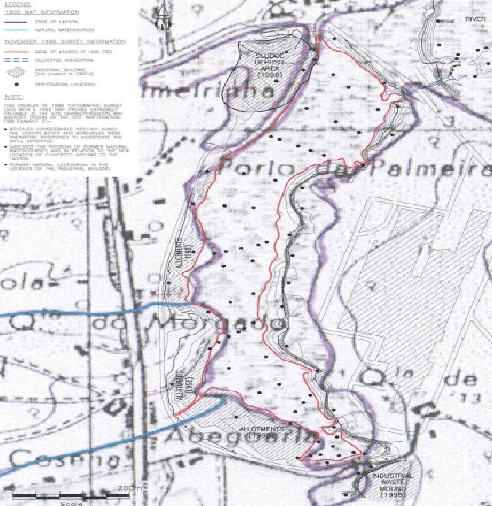
The following general illustration expresses assimilating values of topographical surveys with historical maps.
The Annotated Cross Section of the Cap would be installed over the waste to achieve the remedial objectives
By definition, capping constitutes a procedure made use of in covering contaminated exposed soils for the prevention of pollutant migrations. Capping and reprofiling of the Harpurhey may include installing leachate drainage as well as clay migration (or import) to the site. The migration is directed toward a defined region. For the Harpurhey site in consideration, evidently, migrations could result from activities of rainwater and from the vertical or running movements of water on surfaces. Because caps are produced from varying fiber materials, they are known to meet task stipulations in diverse ways. These may include the prevention of water moments that are vertical over the contaminated soil and which explains the reason why reprofiling and capping of contaminated materials is resolved the most accepted remedial solution which offers the least migration-breaking-pathway cost for the Harpurhey site. The cap is such that it constitutes the following:
- water percolating into the waste;
- future recreational users of the site from coming into contact with the impacted material; and
- any contaminated run-off into the adjacent reservoir.
Generally, Capping provides appropriately-organized surface-water drains from defined sites for the prevention of stagnancy in water. There should be ease of maintenance. There must be damage resistance resulting from soil consolidation as well as from thermal emotions, Ultra-Violet emissions, and so on. The cap would need periodical monitoring to ensure that the overlying soil settles. This monitoring is majorly achieved through groundwater-monitoring wells. Cap-materials that constitute synthetic liners made use of as barriers against outside-liquid flows could last two-decade base on design. Under CLAIRE’s CoP, an ultimate cap requires inspection consistently in order to monitor erosion and soil settlings. Fundamentally, capping off the Harpurhey is required for minimizing rainwater or surface-water and contaminated soil contacts.
When working on the CLAIRE code, multilayer caps are usually in preference for use. It is emphasized:
This type of cap generally has four layers: vegetation, drainage, water-resistant and foundation. The vegetation layer prevents erosion of the soils of the cap. The drainage layer channels rainwater away from the cap and keeps water from collecting on the water-resistant layer which covers the waste (Lazarus, 2004).
The base layer constitutes soil materials that are able to support weights due to their structure. CLAIRE stipulates that used capping materials should cover the waste up to 6-inches. Structural stability tests are required for running on several increments of the cap for equivalence assurance.
It has been noted that:
The thickness of the water-resistant layer should be at least two feet but should be increased if settling is expected in the underlying contaminated soils. A synthetic liner should be placed and sealed according to the manufacturer’s specifications. The liner should be at least 20 mils thick (Lazarus, 2004).
However, thick liners could be made use of in situations whereby there is an expectation for more than a few settle-inches.
Conclusively, capping provides an acceptable contaminated-site seal technology and reduces migrations that occur beneath ground-level to improve human-heath protection as well as environmental protection.
From the guidance from CIRIA and the remedial objective of the CSM which have been discussed in earlier tasks, the following cross-sectional view of the installment over the waste for the achievement of remedial objectives is shown as follows:
Reference List
Cieniawski, T., 2008. Effects of tap water lead, water hardness, alcohol, and cigarettes on blood lead concentrations. Journal of Epidemiology and Community Health 37 1–7.
Conant, B. Paustenbach, D. Finley, B. and Long, T., 2004. The critical role of house dust in understanding the hazards posed by contaminated soils. International Journal of Toxicology 16 339–362.
Environmental Protection Agency (EPA), 2006. WildNet, Online database, Fitzroy Basin Wetland Summary information.
Environmental Protection Agency (EPA), 2008. WildNet, Online database. Brisbane.
Lazarus, R., 2004. The Making of Environmental Law. University of Chicago Press: Chicago.
Malcolm, P., 2005. Survey of blood lead levels in the population in England. In Recent Blood Lead Surveys, Report R9, Institute of Environment and Health, University of Leicester.
McGrath, P. and Loveland, P., 1992. The Soil Geochemical Atlas of England and Wales. Blackie, London.
Merry, J. Tiller, K. and Alston, A., 1983. Accumulation of copper, lead and arsenic in some Australian orchard soils. Australian Journal of Soil Research, 21 549–561.
R&D Technical Report P5-065/TR: BGS/EA., 2000. Some Guidance on the Use of Digital Environmental Data BGS Technical Report WE/99/14, EA NGWCLC Report NC/06/32.
Wixson, B. and Davies, B., 1994. Guidelines for lead in soil. Environmental Science and Technology 28 (1) 26A–31A.