Geographic Information System (GIS)
Geographic Information System (GIS) can be used in Melbourne as a powerful tool for accessing hidden locations (Carter and Rinner 351). TSF includes locations such as Halal butcheries, Islamic schools, Islamic hospitals, mosques and so on. By applying GIS in the most appropriate manner, an Islamic visitor in Melbourne city can reduce both the time taken and distance covered to access a service or facility (Eastman 29).
The GIS methodology that can be used to access Islamic services in Melbourne requires two broad procedures (Amiri et al 640). First, a network of accessible streets should be identified. The streets should be those linking Islamic facilities like schools, hospitals, butcheries and mosques. Second, using demographic characteristics of this city, the transit market potential should be estimated. This objective can be attained using a GIS program that has the potential to visualize and analyze the existing demographic data (Yin 2925).
In order to demonstrate the methodology in the most appropriate manner, a case study should be used. For instance, a portion of a network route within the targeted areas in Melbourne is given proper analysis. In addition, an estimation of Transit Potential’s index is conducted. TFS’s (mosques, halal butcheries and so on) can then be located using index values. Since this process requires articulate management of the available information, a GIS tool like Arc View can be of great help. Planning and travel patterns are also instrumental irrespective of the GIS tool used. For example, means of transport being used in Melbourne is important when locating places.
Spatial population distribution of Melbourne
Australia’s population and in particular Melbourne city is highly diverse in terms of spatial distribution. Figures derived from the 2011 population census reveal that 25 percent of the entire Melbourne’s population was born abroad (Sui and DeLyser 116). Ancestry diversity in Melbourne is also another crucial area when discussing spatial distribution.
To begin with, Melbourne is among the largest Australian cities. Its population profile is multicultural and diverse. By 2025, Melbourne’s population is expected to pass beyond the 5 million mark. It currently has a population of slightly above 4 million. A total of 116 religious faiths are practiced in Melbourne, Islam being one of them. The Asian population is the second largest group in Melbourne. About 100,000 Muslims reside in Melbourne city.
Ethical mix of Melbourne is also evident. The degree of ethical segregation in Melbourne is crucial in this discussion. In addition, it is vital to note that Islamic facilities in Melbourne have been largely overshadowed by other physical developments bearing in mind that Islam is not dominant religion in this city. Gaining access to crucial services within Melbourne city is a challenge that many residents face on a daily basis (Blaschke 186).
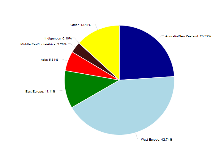
Figures provided by the Australian Bureau of Statistics indicate the following: Italians (5.5 percent), Scottish ((5.7 percent), Irish (6.9 percent), Australian (20.7 percent) and English (21.1 percent). These are the dominant Melbourne’s ancestries. The population profile of Melbourne shows that all the ancestral groups are evenly spread inside and within the outskirts of the city.
The spatial distribution has been summarized in the chart below:

Works Cited
Amiri, Naeim, et al. “Analysis of the Spatial-local Distribution of the Sport Complexes using GIS System.” Scientific Journal of Pure and Applied Sciences 3.7 (2014): 636-644. Print.
Blaschke, Thomas. “Geographic Object-Based Image Analysis–Towards a New Paradigm.” ISPRS Journal of Photogrammetry and Remote Sensing 87 (2014): 180-191.Print.
Carter, Brad, and Claus Rinner. “Locally Weighted Linear Combination in a Vector Geographic Information System.” Journal of Geographical Systems 16.3 (2014): 343-361. Print.
Eastman, Ronald. IDRISI Kilimanjaro: Guide to GIS and Image Processing. Worcester: Clark Labs, Clark University, 2003. Print.
Sui, Daniel, and Dydia DeLyser. “Crossing the Qualitative-Quantitative Chasm I Hybrid Geographies, the Spatial Turn, and Volunteered Geographic Information (VGI).” Progress in Human Geography 36.1 (2012): 111-124. Print.
Yin, Li. “Neighbourhood for Playing: Using GPS, GIS and Accelerometry to Delineate Areas within which Youth are Physically Active.” Urban studies 50.14 (2013): 2922-2939.Print.