Introduction
Global warming is considered to be one of the most serious problems in the world. Many scientists tackle these problems regarding the results of this ecologic phenomenon but not its causes. Therefore, it is necessary to pursue how the development of human activities and industry allocation influence the environmental pollution in different areas thus causing acid rains and the greenhouse effect. In particular, the main reasons for global warming are human activities revealing gas production. Those gases hamper the Sun’s heat within the atmosphere and one of such gases is carbon dioxide. Our purpose is to track the climate changes in the different zones on the planet with the help of geographic information. Further, it is necessary to define the role of GIS for problem-solving.
Main Body
Literature Review
For the GIS project, it is necessary to study the main aspects and problems of global warming and the way it affects the geographic presentation of the planet. In particular, it is possible to investigate the figures of temperature degree and sea level. The study by Chris Oxlade allows us to understand the complicated process of climate chain leading to specific changes in the atmospheric layers and lessening the glacier zone in different periods (217).
The study by Longley provides significant data about geographic information systems, their definition, and their role in analyzing different problems of everyday life. The book proves that both regional and global problems can be predicted if using different map data. The book also discusses the importance of GIS for society in political, cultural, economical terms (Longley 4).
Methods of Global Warming Analysis
The analysis of the database involves the comparison of different maps designs and their layers depicted on the maps. Hence, in our GIS project, we will perform a spatial interpolation analysis to investigate the temperature characteristics and see level parameters. After maps analysis, we will conduct an overlay analysis to identify the link between the sea level rise and temperature changes.
Planned Analysis
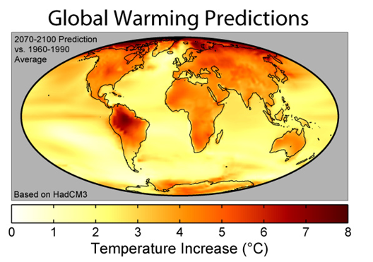
Global warming is revealed through the dramatic growth of the temperature on the Earth within specific temporal periods. In this regard, the consideration of two different maps will show the percentage temperature growth.

According to the map, the rise of temperature is concentrated in the Southern regions of the planet. Therefore, it is possible to predict that the glaciers in the South will become thinner.

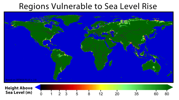
To pursue the climate shifts and see the differences in sea level, it is necessary to analyze the maps and GIS data with different temporal and spatial characteristics. In particular, temporal characteristics can be seen when analyzing the see level on different maps. Sea level shifts can be analyzed according to the most identification of the most vulnerable land areas.

The map shows the land height above the sea. In this way, we will analyze what territories are under the threat of thinking.
Findings and Results
The investigation of temperature rise reveals that the most rigid changes take place in the South part of the planet. This can be explained by numerous reasons. The heat trapped within the atmosphere destroys the ozone layer in the South leading to the penetration of radiated rays. In its turn, thinner ozone level contributes to the rise of temperature. Viewing the map in comparison, one can notice that the most vulnerable land areas are located in the South, which is explained by glacier melting. As it can be viewed, the GIS data can greatly promote the understanding of the problem and foster its solving.
Works Cited
Longley, Paul. Geographic information systems and science. US: John Wiley and Sons, 2005.
Oxlade, Chris. Global Warming. Mankato, MN: Capstone Press, 2006.