Introduction
Hurricane Ike was a strong tropical cyclone that covered part of Northern America and the Greater Antilles in 2008 causing massive destruction on agriculture and infrastructure (Sebastian et al. 173). Scientists regard it as one of the most destructive cyclones in the history of the United States. It started as a tropical disturbance near Cape Verde on September 1 and grew into a full-blown storm on the evening of September 3. On the first day of the incident, Ike subsided during overnight hours due to the effect of northerly wind shear. However, the following morning, the winds were calm giving it a window to intensify. By September 3, the storm had gained momentum to almost becoming a hurricane, and by mid-afternoon, it transformed into a cyclone. Sebastian et al. say, “Ike then explosively intensified and was upgraded to a major storm with winds of 185km/h only three hours after being declared a hurricane” (175). It continued to intensify and was later promoted to a group 4 hurricane. The storm reached maximum strength in the morning hours of September 4 with winds of 230 km/h. The initial landfall of Hurricane Ike happened on September 7 when it reached Caicos and Turks Islands.
Hurricane Ike had both social and economic effects on the countries that it affected. According to Morss and Hayden, a lot of property was destroyed leaving thousands of families homeless (181). In Turk Island, at least 80% of the families lost their property (Morss and Hayden 181). Moreover, health facilities were damaged leading to the interruption of essential medical services. The destruction of a local pharmacy impacted the distribution of prescription drugs in the Island adversely. In Haiti, the hurricane resulted in a major humanitarian crisis due to the destruction of infrastructure. It triggered floods that washed away the only remaining bridge in the city of Gonaives (Morss and Hayden 184). Hence, it was hard for charitable organizations to supply the city with food and other humanitarian services. At least 74 people died as a result of the hurricane. In Houston, Texas, many people went without food for weeks in the wake of the damages that storm caused.
Pan alleges that most oil refineries and chemical plants were shut down in Texas (37). It resulted in a short-term increase in oil prices across the United States. The destruction in Louisiana, Texas, and Arkansas cost insurance companies at least $29.5 billion in claims, making the hurricane the third most destructive storm in the history of the United States. Pan maintains that the actual economic impact of the storm could be higher than what was reported (41). Ike had adverse economic effects on cattle ranchers who lost at least 4000 animals (Pan 44). Additionally, the hurricane resulted in the alteration of soil conditions, which affected crop production for many years. The agricultural output went down by nine percent in 2009 (Siebeneck et al. 2271).
The scientists were unable to forecast hurricane Ike effectively to give warning to the local people. Variations in the intensity of the storm made it hard for them to predict the duration it would take before initial landfall. The storm surge started earlier than expected. Consequently, many people were caught off guard. In Galveston, over 100,000 families were still in the area.
Synoptic History
Hurricane Ike started due to a well-defined tropical storm that originated from the west coast of Africa and moved towards the Gulf of Mexico. Williams posits, “An area of low pressure developed along the wave axis early the next day and produced intermittent bursts of thunderstorm activity as it moved south of the Cape Verde Islands on 29 and 30 August” (904). The wave could not sustain organized deep convection for two days. However, by September 1, it had acquired sufficient convective organization to qualify as a tropical depression. The depression grew in strength and transformed into a tropical storm by mid-morning on the same. The storm “intensified significantly in the next two days as it traveled towards the tropical Atlantic, guided by an excellent subtropical crest to the north” (Williams 904). At this time, “Ike was surrounded by dry air and was unable to develop organized inner core convection, which possibly contributed to the slow strengthening rate during the early part of the storm’s existence” (Williams 906).
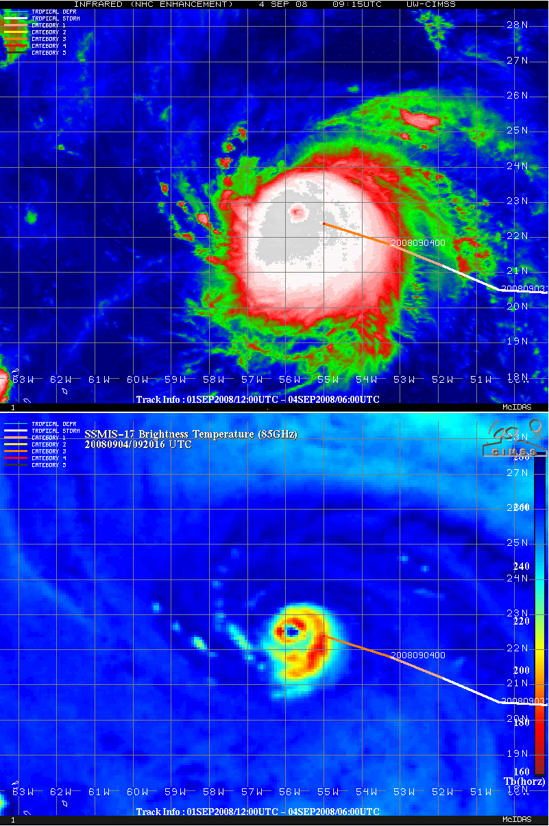
A study of the microwave satellite images showed that powerful convective banding was already encircling the heart of Ike by noon of September 3. At around 1800 UTC, it was easy to spot an eye, and Ike had transformed into a hurricane. The presence of the storm in a region with practically no wind shear contributed to Ike experiencing volatile intensification (Berg 1). It reached maximum strength in a span of six hours after the scientists pronounced it a hurricane. The figure below represents a satellite image of the hurricane recorded on September 3.
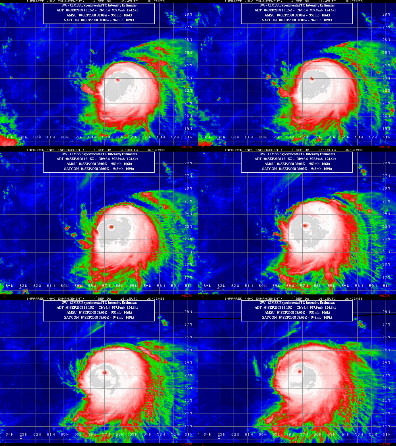
Around this time, “a deep-layer of a low-pressure area over the northwestern Atlantic weakened the subtropical ridge and allowed Ike to move on a west-northwestward track” (Berg 2). Even though the atmospheric conditions could support the intensification of the hurricane, “the northerly upper-level winds on the west side of the low were high enough to somewhat restrict the outflow on the north portion of the storm” (Berg 2). Further, satellite images showed that in spite of the hurricane sustaining a sharp eye for the better part of the morning hours of September 4, its appearance deteriorated gradually as the day unfolded. The strength of the hurricane also decreased significantly. The figure below represents a satellite image of the hurricane recorded in the late hours of September 4.
Berg claims, “Later, on September 4, Hurricane Ike changed its direction and headed west due to the accumulation of mid-level high pressure along the western Atlantic” (2). The high was powerful enough to trigger an unclimatological movement of the hurricane towards the west-southwest direction. On the early morning of September 6, the northeasterly shear winds subsided as Ike was gradually approaching Caicos and Turks Islands. It facilitated the re-intensification of the hurricane leading to Ike regaining Category 4 status.
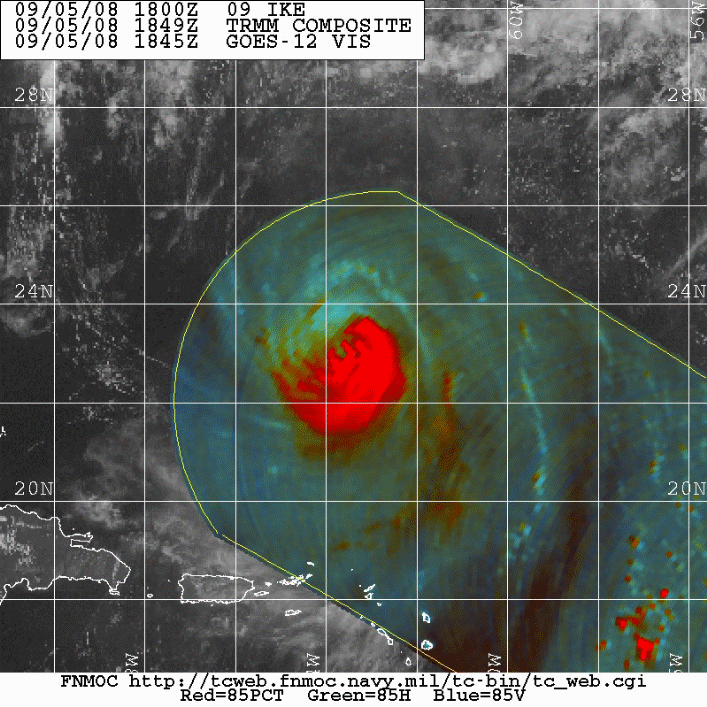
On September 6, the storm lost its strength at about 240km away from the Grand Turk Islands due to powerful wind shear. In spite of the wind shear subsiding and allowing Ike to re-intensify, the strength of the hurricane varied for the next few days. The microwave satellite images taken on September 6 showed that “much of the deep convection over the northern semicircle was severely eroded; including the northern eyewall, but a small eye was still visible” (Berg 2). Ike lost much of its strength and fell back to Category 3 status before crashing on Great Inagua Island in the Bahamas. Below is an image of Hurricane Ike after significant erosion of the deep convection.
The landfall on Inagua led to the formation of a double eyewall, which affected the strength of the storm. Nevertheless, Ike regained intensity and reached Category 4 status allowing it to make landfall near Cabo Lucrecia in Cuba on September 8 (Zhao and Xue 22). In spite of the hurricane remaining active as it traversed eastern Cuba, its nucleus had become unstable by the time it reached the Caribbean Sea. On September 9, the storm traveled westward along the southern coast of Cuba at a limited intensity with its center coming close to the coastline. Data from aircraft reconnaissance indicated that the strength of the hurricane increased progressively for about 18 hours after leaving the southern coast of Cuba. Nevertheless, images obtained from the observation report and satellite revealed that Ike had a configuration, which inhibited its swift intensification. On the same day, it made another landfall closer to Punta La Capitana and resurfaced at the Gulf of Mexico. The interaction with Cuba “affected the hurricane’s inner core resulting in the expansion of the wind field as it approached the Gulf of Mexico” (Berg 2).
On September 10, the hurricane traveled leisurely in the northwest direction over the southeastern Gulf (Berg 3). The outer banding started to enfold the tiny eyewall that had endured the crossing of Cuba. The process inhibited swift spiraling of the hurricane with its winds reaching 85 knots (Berg 3). Moreover, “hurricane-force winds and the tropical storm intensified, reaching 100 and 240 nautical miles respectively, from the core” (Berg 3). Aircraft data collected at 1800 UTC indicated that the hurricane had two distinct wind maxima with equal power. Sherman et al. aver, “The unusual broad distribution of high winds were associated with surface central pressures that were much lower than would be expected for the winds that were measured” (74). The pressure in the Gulf of Mexico was 944 millibars, which resulted in the reduction of the speed of the hurricane.
As the storm swept through the Gulf of Mexico, high winds emanating from the east of the eye led to the generation of huge waves. Berg claims that the waves were as high as eight meters and lasted for at least 12 seconds (3).
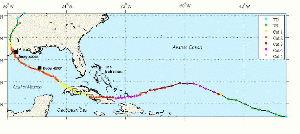
By late September 10, “the strength of subtropical ridge grew forcing Ike to change course and travel in the west-northwest direction” (Berg 3). Berg argues, “Moving over the warm waters of the Loop Current, Ike reached a secondary minimum in barometric pressure on 0000 UTC with an estimate 944mbar” (3). The storm’s pressure continued to increase despite the strengthening of the power of the winds. On September 12, the hurricane’s inner core convection remained weak leading to Ike upholding its broad wind field. The hurricane contacted the western rim of the neighboring region of elevated pressure towards the end of September 12 forcing it to bend northwards. The winds increased significantly due to the creation of an eye a few hours before landfall. The hurricane reached the northern edge of Galveston Island on September 13 at 0700 UTC (Berg 3). Its center “swept through Galveston Bay on the east of Houston before traveling northwards towards Eastern Texas” (Berg 3). Ike lost its strength and turned into a tropical storm before reaching Palestine, Texas. Ike then transformed into extratropical after coming into contact with a front as it traveled northeastwards across southern Missouri and northern Arkansas. On September 14, “the active extratropical low moved swiftly northeastwards, generating hurricane-force wind bursts around Ohio Valley” (Berg 3). Later in the day, the hurricane subsided and traveled across southern Ontario and Quebec. The figure below represents the path that Hurricane Ike followed from the Atlantic Ocean to the Gulf of Mexico.
Hurricane-Force Winds
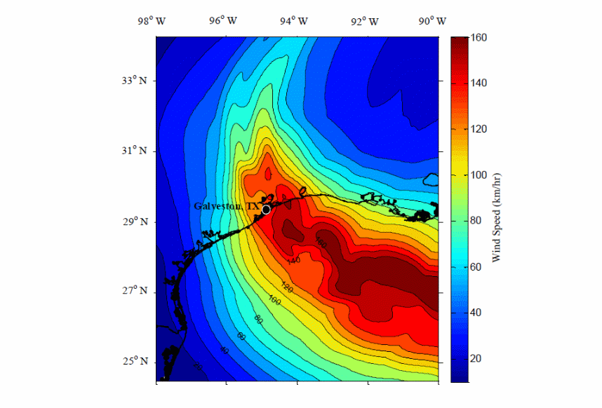
Du et al. aver, “The maximum sustained wind swaths estimated by the NOAA Atlantic Oceanographic Meteorological Laboratory Hurricane Division indicated that the hurricane-forces winds impacted approximately 180 km of coastline” (23). The data showed that the winds traveled at maximum speed as they reached east of Galveston, Texas. The hurricane-force winds maintained their course as they swept across Galveston Island and Bolivar Peninsula. However, they changed the direction after the center of the hurricane made landfall. Du et al. argue that as the storm drew closer to the coast and made landfall, “the winds transitioned to shore-normal orientation, blowing onshore northeast of landfall and offshore southwest of landfall” (25). The storm swept across the eastern Galveston Bay, which was already flooded as a result of the forerunner surge triggered by the landfall. The hurricane-force winds swept across the Louisiana-Texas border and had a significant impact on the Louisiana coast. The figure below represents wind speeds as observed by NOAA.
Offshore Wave Climate
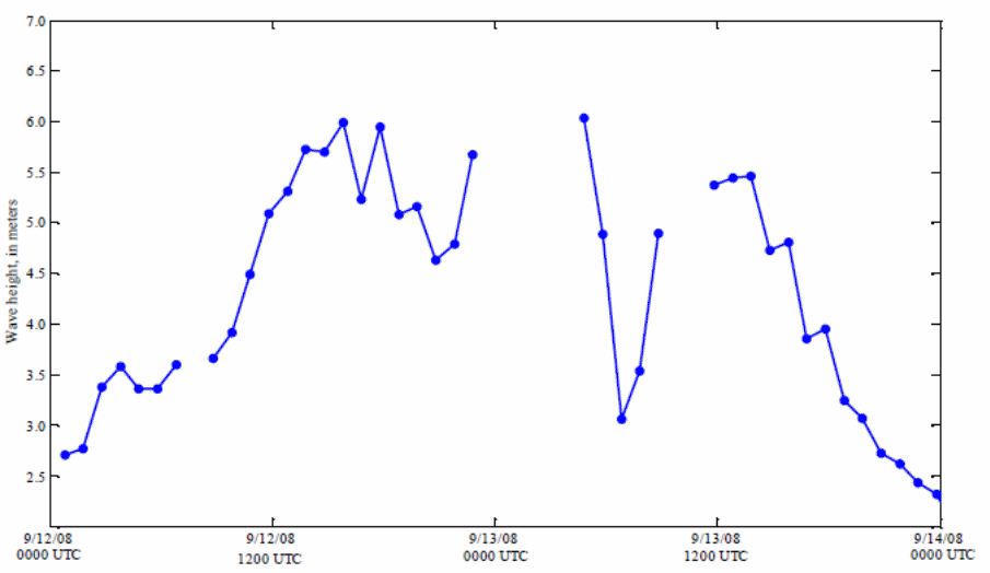
The National Oceanic and Atmospheric Administration used moored buoys to record the amplitudes and frequencies of waves caused by Hurricane Ike. About 33 hours before landfall, the hurricane traveled close to one of the buoys stationed in the Gulf of Mexico (Hope et al. 4425). It recorded the greatest amplitude of 9.2 m. As the hurricane traveled across the Gulf of Mexico, the storm’s most high winds located on the eastern side of the eye, led to the generation of massive waves. The buoys on the northeastern Gulf captured significant wave amplitudes of between four and eight meters. The maximum frequencies of the waves ranged between 10 and 12 seconds (Hope et al. 4429). A moored float located east of Galveston, Texas went through the core of the hurricane, capturing maximum significant wave amplitude of 6.0 m. The figure below represents the recorded significant wave heights.
Storm Surge
According to Doran et al., the data about storm surge is gathered using land-based storm antennas and coastal tide gauges (4). Additionally, scientists use high-water marks to determine the maximum wind gush. A majority of the coastal tide gauges were operational during Hurricane Ike and helped to collect data on the pattern of the storm surge. The data indicated that the maximum storm surge occurred at all Gulf Coast States as the hurricane entered the Gulf of Mexico. Doran et al. posit, “The large wind field pushed water towards the coastline well before landfall” (5). The maximum storm gush went as high as 0.87 m above the normal tides, particularly on the coast of Florida. The shores of Southeastern Louisiana, Mississippi, and Alabama witnessed maximum storm surges that ranged between 0.79m and 1.98m. A majority of the tide gauges located close to the landfall did not work because of large wave action, which damaged the platforms holding the instruments. Doran et al. claim “On the Bolivar Peninsula, high-water mark indicated that the entire area was covered by one meter of water” (6). The high-water marks at Galveston Island revealed that the storm surges ranged between 3m and 4.5m. The hurricane’s atypical broad wind field in the Gulf of Mexico resulted in the occurrence of numerous surge processes along the coast and LATEX shelf.
Conclusion
Hurricane Ike was among the most destructive storms to have ever been experienced in the United States. It resulted in the country losing at least $29 billion in property damage, not to mention the many people who lost their lives. The inability to predict the behavior of the storm led to state officials not issuing early warnings. In Houston, the officials were reluctant to request the public to evacuate the area, leading to at least 140,000 residents not leaving on time. Variations in weather conditions have made it hard for scientists to predict the occurrence of hurricanes. Nevertheless, an analysis of historical data shows that a storm akin to Ike is bound to occur in the future. It is hard to tell if the scientists, state officials, and the public as a whole learned a lesson from Ike. One may argue that the state’s function contributed to the impacts of the hurricane. The state was not prepared to evacuate people from areas that were vulnerable to the cyclone. However, people should appreciate that the climate also played a great role. The inability of the scientists to predict the movement of the storm was due to variations in weather conditions.
Works Cited
Berg, Robbie. Tropical Cyclone Report: Hurricane Ike. National Hurricane Center, 2009. Web.
Doran, Kara, et al. Hurricane Ike: Observations and Analysis of Coastal Change. Reston, Virginia, 2009, U.S. Department of the Interior.
Du, Ningzhu, et al. “Impact of Assimilating Airborne Doppler Radar Velocity Data Using ARPS 3DVAR on the Analysis and Prediction of Hurricane Ike (2008). Journal of Geophysical Research, vol. 117, no. 18, 2012, pp. 21-34.
Hope, Mark, et al. “Hindcast and Validation of Hurricane Ike (2008) Waves, Forerunner, and Storm Surge.” Journal of Geophysical Research, vol. 118, no. 9, 2013, pp. 4424-4460.
Morss, Rebecca, and Mary Hayden. “Storm Surge and “Certain Death”: Interviews with Texas Coastal Residents Following Hurricane Ike.” Weather, Climate, and Society, vol. 2, no. 1, 2012, pp. 174-189.
Pan, Qisheng. “Estimating the Economic Losses of Hurricane Ike in the Greater Houston Region.” Natural Hazards Review, vol. 16, no. 1, 2015, pp. 35-53.
Sebastian, Antonia, et al. “Characterizing Hurricane Storm Surge Behavior in Galveston Bay Using the SWAN + ADCIRC Model.” Coastal Engineering, vol. 66, no. 1, 2014, pp. 171-181.
Sherman, Douglas, et al. “Impacts of Hurricane Ike on the Beaches of Bolivar Peninsula, TX, USA.” Geomorphology, vol. 199, no. 1, 2013, pp. 62-81.
Siebeneck, Laura, et al. “Evacuees’ Reentry Concerns and Experiences in the Aftermath of Hurricane Ike.” Natural Hazards, vol. 65, no. 3, 2013, pp. 2267-2286.
Williams, Harry. “Magnitude of Hurricane Ike Storm Surge Sedimentation: Implications for Coastal Marsh Aggradation.” Earth Surface Processes and Landforms, vol. 37, no. 8, 2012, pp. 901-906.
Zhao, Kun, and Ming Xue. “Assimilation of Coastal Doppler Radar data with ARPS 3DVAR and Cloud Analysis for the Prediction of Hurricane Ike (2008).” Geophysical Research Letters: An Agu Journal, vol. 36, no. 12, 2013, pp. 17-31.