Oil is an incredibly important resource that can be credited for the growth of the United States economy. This impact of oil on the economy resulted in a struggle between the production of economical fuel and environmental conservation questions. In 1968, oil was discovered at Prudhoe Bay by Atlantic Richfield Company (ARCO). The problem that came with the discovery was that the oil fields were 250 miles north of the Arctic Circle. This situation created a need for an efficient system from North Alaska to the lower 48 states refineries for the transport of crude oil.
After considering various methods of transport such as icebreaking tank vessels, extending the Alaskan railroads, and/or establishing giant tanker airplanes, the oil companies determined that a hot-oil pipeline would be both efficient and economical. The pipeline would run from the North Slope to the Port of Valdez. The oil would then be shipped to the US coast through tank vessels. The ensuing discussion examines the Trans Alaska Pipeline.
Location
The pipeline transports crude oil from the fields in Prudhoe Bay south to the Port of Valdez. The distance is 800 miles long. It traverses earthquake and permafrost regions. The pipeline passes through about 30 major rivers and several streams, as well as the Alaska, Brooks, and Chugach ranges. The Valdez Marine Terminal, which covers 1,000 acres of land is the northernmost ice-free zone. It was the most convenient to end the pipeline. The whole project has over 124,000 heat pipes. They operate in a way that the heat they release goes into the air. In this way, the soil remains cool. In case the heat is released into the soil, it leads to the melting of permafrost, thus destabilizing the pipeline. The average temperature along the pipeline ranges from -80F to 95F (Alaska Public Information Centers, 2015).
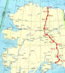
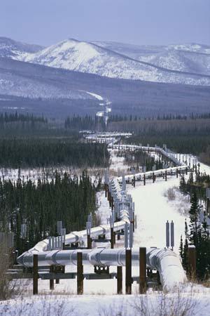
The Trans Alaskan pipeline (TAPS) is protected by three separate systems of leak detection. The systems are monitored in Anchorage where the Operations Control Centre (OCC) is located. The OCC is the point where the pipeline is monitored and operated all hours of the day. Of the 800 miles of pipeline length, a 420-mile distance is elevated from the ground using 78,000 vertical support members. This elevation is done in permafrost-infested areas to prevent the heat pipes from melting it to the level of causing instability to the pipeline. At Atigun Pass, it is elevated up to 4,739 feet, which is the highest point of its elevation. The other 320-mile-long pipeline is buried. The project has 11 pump stations that accelerate the speed of flow of the hot crude oil to about 4 miles per hour. The pipes have a diameter of 48 inches. This figure translates into 1.2 meters.
Culture and Society
The first Alaskan inhabitants dating back about 20,000 years came from Siberia through the Bering Land Bridge. The culture of the natives has since been influenced by both the Klondike gold rush and Russian Orthodox churches. In 1924, citizenship was passed to Alaskan natives and Native Americans. Alaska then became the 49th state of North America in 1959. Three years later, north America’s largest oil field was discovered in Prudhoe Bay. The pipeline construction commenced in 1974 and ended in 1977 (Alaska Public Information Centers, 2015).
A committee referred to as the Trans-Alaska Pipeline System (TAPS) was formed by the three companies that owned the majority of the oil fields in Prudhoe Bay. Their aim was to build the pipeline rapidly. However, the fields were under disputes from natives who claimed their land. As a result, there was immense opposition to the construction of the Trans-Alaska pipeline. Therefore, Stewart Udall who was the then Secretary of the Interior temporarily halted the project.
The National Environmental Policy Act (NEPA) was passed by the parliament in 1969. Therefore, the construction of the pipeline influenced both the economy and the interaction between development and environmental conservation. Concurrently, the natives claimed that the pipeline was going to cross through villages that they owned at their peril. Therefore, they filed suit for the termination of the project (Alyeska Pipeline Service Company, 2011).
In 1971, the Alaska Native Claims Settlement Act was signed. It led to the resolution of the disputes, thus allowing room for the construction of the pipeline. Although there were numerous native tribes in Alaska at the time when the oil was discovered, the total population was low. The state also lacked an economic base that could sufficiently support the population. Therefore, the federal government funded Alaska.
Therefore, the discovery of oil came as a good option of salvaging the Alaskan economy. The Alaskan natives were also greatly concerned about the impact that the pipeline would have on the environment. Environmentalists were also skeptical. They cited the 1969 oil spill in Santa Barbara that resulted in massive loss of sea creatures. Although scores of people moved to Alaska for the construction of the pipeline, it also provided jobs for the people of the Alaskan natives. Therefore, the pipeline not only influenced the economy but also the people.
Even after the project, consequent projects have been opposed by the natives. The Gwich’in community of North America relies on the Porcupine Caribou, which is a migratory herd for food and cultural rituals. This practice has been the case for thousands of years. The Gwich’in Steering Committee was formed in the Arctic Village to protect the rights of the Gwich’in people who have inhabited the migratory route of the Porcupine Caribou up to date. According to the Committee, opening up the area for development posed a menace to the breeding of the Caribou, thus threatening the Gwich’in community. The committee asserted that the oil development endangered the culture and society of the Gwich’in (Alaska Public Information Centers, 2015).
Construction of TAPS
The construction of TAPS began in 1975 after the Department of the Interior offered Alaska a federal license permitting the erection of the pipeline project. Pipeline operators utilized the technology that was existent at that time to moderate the impact of severe ecological happenings. The presence of new construction techniques and Dalton highway helped the workers to develop one of the largest pipelines at the time of construction.
According to Alyeska Pipeline Service Company (2011), the project researchers conducted aerial surveys and assessed the primary route to determine the features of the environment. Thick vegetation was cleared to enable the surveyors to proceed with the study. Cliffs were also used in rocky areas such as Atigun, Isabel, Thompson, as well as Keystone Canyon to clear the route for the survey. At Denali Fault, the surveyors observed the need to construct slider supports and insulation of the pipes to protect the pipeline system from the exceedingly low temperatures that could break the materials.
Nonetheless, environmentalists opposed the idea of building subterranean pipeline crossing by noting that it would interfere with the life of the Caribou. Therefore, pipeline operators opted to establish a structure that cooled the pipe through chilled brine in areas with permafrost. Styrofoam and gravels were also used to enhance the quality of insulation of pipes under the refrigeration plant. Generally, the refrigerated areas covered about 5.6 km of the entire pipeline system.
For regions without permafrost, researchers concluded that it was sufficient to lay the pipes underground with no refrigeration. It was necessary to use plenty of gravels to prevent high surface temperature from melting permafrost while constructing road used for transporting materials and monitoring the pipeline. Several sites were discovered that could supply gravels for the construction. The topography of area highly influenced the design of the project.
For instance, since the pipes had to go through Denali Fault, which had frequent earthquakes, the engineers constructed Teflon-coated sliders to overcome the impact of any tremor. Additionally, to limit the impact of thermal expansion because of the hot temperature, TAPS was designed with an S-shape such that the pipes could not be damaged during expansion. Radiators were used to maintain freezing permafrost (Alaska Public Information Centers, 2015).
The pipeline path also had numerous rivers. Hence, engineers had to use effective techniques to avert potential risks such as the oil spillage. Concrete jackets were used to sink the pipeline into the rivers. Since the pipes were transporting oil, they would scientifically float on water. However, environmental activists objected the move since they feared that it would alter the flow of water and that any oil spillage would result in serious ecological destruction. Consequently, pipeline bridges were built in some rivers such as in Yukon River. Oil spillage was controlled through one-way regulators. The one-way valves prevented oil from spilling after passing a hole by a given distance. In case of spillage, the pipeline operators could quickly discover it because of change in pressure before pausing the oil transportation until when the hole was sealed. The vessels also had a cathodic protection plan to avert any corrosive impact of the wet topography (Naske & Slotnick, 2014).
Welders fusing pipes
Bechtel Corporation and Flour Corp. were selected to manage the erection of TRAPS while several subcontractors were granted the responsibility of performing the actual building. Camps were also built to house laborers with each having an average of 16,500 beds. By 1975, the project had attracted about 28,000 with roughly 19% comprising individuals from minority communities. However, it is estimated that 70,000 worked on the project because of poor worker retention. The Teamsters Union also offered a considerable number of human resources who assisted in the supply of pipeline materials.
Most the project welders and operators were hired from Pipeliners Local 798 and the International Union of Operating Engineers respectively. Engineer Frank Moolin, Jr., managed the entire project. He was a dedicated leader who made various critical decisions that ensured that the project was completed successfully. For instance, he introduced the ‘Alyeska Sweepstakes’ program whereby the performance of the contractors was evaluated to determine the most hardworking group. He also terminated the Bechtel contract when he felt that the company was creating unnecessary bureaucracies (Alaska Public Information Centers, 2015).

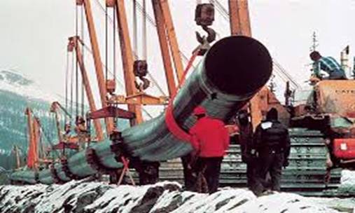
The initial section of TAPS began in Tonsina River where 580m-welded pipe was laid in a ditch du vertically using bulldozers. The pipes were then covered stones until the river outline was restored. A similar process was executed in other sections of the 800 miles. However, laying conduits on rivers was anticipated to be more strenuous than dry land. Conversely, winter made it difficult to burry pipes in the frozen land. Consequently, the engineers had to focus on constructing the pump stations, as well as placing pipes on river crossings.
The pipe-laying process was technical. Foremost, laborers cleared the land using chain saws, excavators, as well as scrapers. Subsequently, inspectors would assess and determine if the topography was conducive for laying pipes. If the area was unfavorable, it would be moved 200 feet sideways with consent from government inspectors. Once the route was confirmed, perpendicular ditches were dug using augers and drillers.
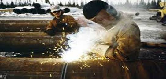
Water, stones, and dirt were then added to the ditches before placing a Vertical Support Members (VSM). These materials would then form a concrete around VSM, which was used to support the oil conduit. The VSMs were hoisted using bulldozers before being placed in a semicircular position on specific intermissions of the sections. Welders were then fused with the VSM under careful supervision of quality checkers who X-rayed the inspected VSMs (Naske & Slotnick, 2014).
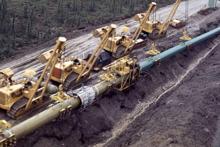
The verification process was sluggish and controversial. In fact, Ketchbaw, which was responsible for performing quality control supervision, was sued. It lost its contract when it appeared that its work was substandard. Alyeska opted to conduct the quality checking. Most of the welds were perceived as dangerous. Alyeska made effort to repair the affected areas. However, inspecting most of the constructed pipes was strenuous since a layer of gravels had already covered most of them. Some of pipes were dug up and rebuilt, a process that cost approximately $55 million.
The pipeline workers also faced serious challenges in three major areas, namely Keystone, Atigun Pass, and Sag River. At Sag, the extreme cold temperatures had interfered with the laying of conduits, thus making it difficult to seal the ditches properly. Consequently, snowmelt caused portion of concrete-insulated pipeline to move to the surface. Since any operations in the area could have affected the migration of Arctic char, the engineers had to seek consent from the relevant authorities. After approval was granted, workers rectified the fault within four hours. Conversely, the topography of Antigun was not conducive for burying conduits because of the prominence of permafrost, as well as avalanche.
Therefore, engineers were forced to construct cover pipes inside concrete about 1.83 km long. Further, they coated the pipes with Styrofoam. The construction had to be conducted to avoid the impact of looming avalanche. At Keystone, the architects had to device a means of reaching Valdez without interfering with the Richardson Highway and Lowe River. The most viable option was to create a route via the Chugach Mountains. This move also meant that the engineers had to overcome the challenges posed by heavy snows and hostile path. Subsequently, the contractors opted to modify the earthmovers. They used helicopters to carry some equipment (Naske & Slotnick, 2014).

Despite the challenges, engineers continued with the construction of the pipeline, the pump stations, as well as the marine terminal. After the completion of the project, the architects proceeded with cleaning the camps as instructed by the Trans-Alaska Pipeline Authorization Act. Heavy equipment was also discarded before TAPS operation could be officially launched. The project was eventually launched in 1977 after nitrogen was pumped through the pipes to remove air and/or allow oil to flow conveniently. Though the project was first projected to cost $900 million, it eventually cost $8 billion as noted by Naske and Slotnick (2014).
Building TAPS Today
Pipeline construction has witnessed remarkable technological advancements over the years. The scientific innovations have focused on improving the durability, speed, and security of environment by transporting oil and gas via the conduits. Building TAPS today would result in the modification of a number of its initial design and structure. However, the location would not be altered. Positioning the pipeline on a different location would only cause more social and legal issues that would tamper with its construction. Furthermore, there exists technologies that can eliminate some of challenges that the original engineers faced during the initial construction.
Najafi (2005) asserts that the pipeline could not have been achieved without the discovery of the Vertical Drilling Technique (VDT), a method that was utilized during the construction of TAPS. However, transportation of oil has advanced with the advent of the Horizontal Directional Drilling (HDD). The HDD is a technique that enables experts to fix pipes, irrespective of the topography’s complications. It also poses minimal harm to the ecosystem as compared to other open-cut approaches.
It is most suitable method where other techniques are hectic or expensive. The method uses a drilling fluid that comprises water, Bentonite, as well as some additives. The fluids are effective in fortifying excavation and controlling friction when placing pipes. These benefits affirmed why it would be crucially useful to use HDD in drilling holes for the construction of TAPS. Most TAPS route had soils that had suffered permafrost. HDD could eliminate the challenges posed by the unfavorable environment.
TAPS was constructed with a potential to overcome an earthquake with a degree of a maximum of 8.5 Richter Scale. Conversely, it was constructed presently, it would have a Design Level Earthquake (DLE) and Safe Level Earthquake (SLE) to limit the advanced impacts of tremors, which are more effective than the one used by the initial engineers of the project. Additionally, there would be the need to ensure that all the river crossings have saddles.
The devastating impact of oil spillage has encouraged stakeholders to utilize advanced technology. TAPS would be fixed with ball valves to limit oil spillage. Moreover, systems that could detect even 1 percent of flow would be used. Fibre optic cable could be used in place of microwave to enhance speed and reliability of communication (Najafi, 2005). Essentially, the present-day pipeline construction technologies could have ensured that TAPS was more reliable, safe, and convenient.
Reference List
Alaska Public Information Centers. (2015). The Trans-Alaska Pipeline. Web.
Alyeska Pipeline Service Company. (2011). Pipeline Facts. Web.
Najafi, M. (2005). Trenchless Technology: Pipeline and Utility Design, Construction, and Renewal. New York, NY: McGraw Hill Professional.
Naske, C., & Slotnick, H. (2014). Alaska: A History. Oklahoma: University of Oklahoma Press.