Introduction
Hurricane Katrina was one of the worst tropical cyclones that caused massive destruction of property and loss of lives in the United States. According to Smith (35), Hurricane Katrina was categorised as the sixth most powerful Atlantic hurricanes in the American history. Many have compared it with other catastrophic hurricanes such as Hurricane Rita and Wilma. According to the NASA reports, the cyclone was first detected on August 23, 2005 in Bahamas.
The meteorologists who were studying it never expected it to grow into a catastrophic hurricane because it was moving at low speeds. As it approached Florida, there were concerns as the speed of the cyclone increased to the levels where it was classified as Category 1 hurricane. It started causing deaths and destruction as it moved with strengthened speed towards the Gulf of Mexico (Reed 41).
The Hurricane gained strength and reached Category 5 as it hit over the warm waters at the Gulf. On August 29, the hurricane finally hit a landfall in south of Louisiana as Category 3 hurricane. The Gulf Coast, especially from Florida to Texas, experienced massive destruction of property and loss of lives as a result of storm surge. The highest number of deaths was recorded in Louisiana and New Orleans as a result of a massive flooding.
The levee systems that had been set in these regions failed catastrophically, and people in the area were left without any form of protection from the hurricane. When it finally died down, 1833 lives were lost and properties worth over $ 81 billion destroyed. In this paper, the focus will be to analyse the interaction of the atmosphere, hydrosphere, and geosphere and the hurricane Katrina disaster.
The Formation of Hurricanes
Hurricanes are tropical cyclones that form over the sea and move violently to the earth, causing massive damages on property and loss of lives. The term Hurricane is used when describing the tropical cyclones that occur in eastern Pacific Ocean or Atlantic Ocean. It is important to understand how the hurricanes are formed, by understanding all the ingredients needed for such a powerful force to be developed.
According to Smith (112), hurricanes will vary in strength based on the quality of ingredients that form it. For a cyclone to occur there must be warm air in the ocean, atmospheric moisture, and a wind pattern near or over the ocean. It is important to understand that hurricanes form over warm waters in the ocean because it needs moist warm air as its fuel. The warm moist air is readily available in ocean waters, especially those near the equator.
The process of formation of a hurricane is a series of processes that take several hours or days in order to be mature enough to cause massive damage on the land. Such destructive cyclones such as hurricane Katrina rarely occur, but it starts in the same way as other minor cyclones. Many of the minor cyclones die in the sea without causing any damage, especially when they are hit with cold air that does not support their movement.
According to Longshore (39), water absorbs heat energy from the sun and can retain this energy for a very long time. During the day when the temperatures are high, the large mass of water will retain the heat energy for a very long time. During the day, the air above the land will be warmer than that over the ocean. This is so because although both water and land receive the same intensity of heat from the sun, water easily stores this heat in its molecules.
On the other hand, land will radiate the heat energy, making it warmer than the sea. At night, the land quickly loses the heat at higher rates than the sea, making the air above the land colder than that above the sea. The retained heat energy in the ocean will be radiated slowly during the night, making air above the ocean warmer as compared to air above the land.
The cyclonic process starts when moist warm air that is over the ocean rises from the surface upwards (Zhu 71). Warm air is lighter than cold air, and for this reason, they will be displaced to higher heights by cold air. When the warm moist air moves away from the surface to higher heights, the volume on the surface where they previously occupied will be less. This will leave some semi-vacuum environment on this surface. The area left in a semi-vacuum state will have low atmospheric pressure as compared to the surrounding areas.
The difference in the air pressure between this surface and the surrounding environment will create a gradient that will force air from the surrounding area into this surface. As the new air moves into this surface through atmospheric pressure, they will find a warmer environment, and after some time, they will also get heated. When they become warm and moist, they will also be pushed upwards.
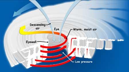
This cyclic movement of air will continue as long as the central location, also known as the eye, remains warmer than other locations within the sea. As this continues, the surrounding air continues to swirl to take place of the rising air. The figure below is an image of the cyclic movement of air around the eye, and how the warm moist air rises to form a cloud.

As shown in the diagram above, as the warm moist air rises, it is hit with colder air, and it reaches a height when it loses its ability to move upwards. When the heat is lost, it becomes cold and heavy and will find its way back to the surface. The moisture that this air carries is left at some heights as a dark cloud ready to cause a storm. Depending on the favourability of the environmental conditions in the ocean, this process may continue for several hours or days.
According to Longshore (21), the cyclones formed north of the equator tend to spin anticlockwise, while those at the south spin in a clockwise direction. This has been associated with the rotation of the earth on its own axis.
When the rotation of the storm system gains higher momentum, an eye will be formed at its centre. This is a calm area with low atmospheric pressure. Above the eye is cold air with higher pressure. Because of the difference in atmospheric pressure, the colder air above surges into the eye, gets warm and is forced out. The diagram below shows the development of a cyclone as it gains momentum.

A tropical storm is formed when the storm’s rotation hits 39 mph. Sometimes the tropical storm does not develop further because of unfavourable air conditions. However, if it gains further momentum, it becomes a tropical cyclone, also known as hurricane, when its speed reaches 74 mph. At such speed, the storm is very destructive, especially when it hits the land. This is how Hurricane Katrina was formed.
The interaction of the atmosphere, hydrosphere, and geosphere and the hurricane Katrina disaster
The discussion above has clearly demonstrated the process that led to the development of hurricane Katrina disaster. It starts with the heat energy from the sun that hits tropical ocean waters near the equator. Both the geosphere and the hydrosphere are heated by the sun. However, the hydrosphere has a higher capacity to retain its heat energy for longer periods than geosphere. In effect, air above the hydrosphere remains warmer when there is a general drop of atmospheric temperatures.
The warm lighter atmospheric air above the hydrosphere will be forced into higher heights by cold air on the geosphere. The atmosphere creates a wind pattern where cold air on the surface of the geosphere moves into the ocean, while the warm and moist air on the surface of the hydrosphere is forced into higher heights.
The atmosphere facilitates the formation of thick clouds that would in turn help, in the formation of the thunderstorm. The tropical storm gains momentum as the movement of cold air from the geosphere into the hydrosphere continues. As mentioned before, this may take several hours or days. At this stage, it would be necessary to emphasise that for the process to continue, there must be a favourable environment in the geosphere, hydrosphere, and atmosphere.
The geosphere must remain warm, especially in the eye of the cyclone. The geosphere must remain cold in order to retain the movement of air into the sea. The atmospheric pressure above the eye of the cyclone must remain weak in order retain the continuous surge of air into it. This demonstrates that the three spheres must have coordinated very closely in the formation of hurricane Katrina. When hurricane Katrina finally gathered enough momentum, had to move to the land where the temperatures were relatively warm.
The reason why hurricane Katrina caused a massive disaster is that it met warm air as it made its landfall, helping it gain high speeds. This caused massive destructions and deaths, as mentioned above. It took time for the geosphere to eliminate the cyclone. In order to manage it, the geosphere needs to hit the cyclone with cold air that will reduce its momentum. It took time for the geosphere achieve this. When it finally did, the damage had already been done. Many lives had been lost, and properties destroyed.
Conclusion
The hurricane Katrina remains one of the worst cyclones in the American history. The cyclone took place with unprecedented force that made it difficult for the government to rescue people in the affected areas. This resulted in massive destruction of properties and loss of lives. It is estimated that about 1833 people lost their lives, while property worth 81 billion dollars were lost.
The hurricane Katrina disaster can closely be related to the activities that happened in the geosphere, hydrosphere, and atmosphere. The difference in temperature of the two spheres enabled the atmospheric air to develop into a cyclone that was very destructive.
Works Cited
Longshore, David. Encyclopedia of Hurricanes, Typhoons, and Cyclones. New York: Facts on File, 2008. Print.
Reed, Betsy. Unnatural Disaster: The Nation on Hurricane Katrina. New York: Nation Books, 2006. Print.
Smith, James. Hurricane Katrina: The Mississippi Story. Jackson, Miss: University Press of Mississippi, 2012. Print.
Zhu, Yong. Large-scale Inhomogeneous Thermodynamics and Application for Atmospheric Energetics. Cambridge: Cambridge International Science Pub, 2001. Print.