The Spatial Data Division of Abu Dhabi: current strategic position
The Spatial Data Division is part of a department responsible for Abu Dhabi’s municipal planning. In a nutshell, our office/division knows where the city is going in terms of plans, prospects and strategies for the future. Private individuals and organisations are some of the customers. This planning office has to provide internal innovations in order to effectively serve its customers.
This office receives many data requests from customers (ordinary citizens, individual landowners, developers, private contractors, etc.) for certain projects or for businesses pertaining to land use.
The division’s database is a depository of spatial maps, charts, statistics and valuable data and information ready for dissemination to citizens upon request. The process is the division’s “building block” and intangible asset which is weakening and needs improvement.

This office offers several services ranging from issuance of documents containing data and information, maps and satellite pictures to land examination / investigation and surveying. Activities for the staff include planning, investigations of lands for ownership, and other spatial matters.
The information and data are voluminous, as they include present information and background, which may be in the form of statistics, charts, maps, and so on.
Information and data include land ownership, references, histories / backgrounds of lands in question, and any valuable information that may have been inputted before but which are significant in planning and creating a built environment (Department of Municipal Affairs: Abu Dhabi city municipality 2014).
Important database contents include planning maps, aerial photographs and satellite images with their corresponding data and information, coordinates of lands, landmarks, and built environment, lands under litigations, and much more. Histories of lands are very important in building new structures, or in determining the usability of such lands.
The voluminous information is also part of the Geographic Information Systems database that may be formulated for plans and strategies of government agencies concerned. Soft and hard copies of the information, such as maps, charts, and other forms, are available upon request. GIS is still in the process of application and may be fully operational sometime in the near future.
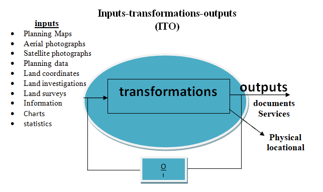
There are many inputs coming from studies, researches, field inspections / investigations, representations, essays and narratives of histories or backgrounds of the different areas and sites within the Abu Dhabi municipality.
Aspects of Operation Management
The 4 Vs analysis
Volume
The Spatial Data Division has high volume of output. Tasks are repeated and the application of technology (GIS) can make the process fast and answerable to the demand. Researchers and investigators provide researches, papers and documents.
Aside from words and numbers, the database contents are replete with aerial and satellite photographs. The staff retrieves these copies and photographs upon request from customers, and they are doing it over and over. Inputs are high and demands from customers are also high.
Variety
There is high variety with many activities. Skills nd technology are needed, because staffs have to perform several tasks like inspection, investigation, and many other inputs.
Activities include retrieving data from the organisation’s database per the customers’ requests. Once these are retrieved from the database, the data and information are contained in a document. Teams also conduct inspections and land surveys. Data and statistics are some of the inputs.
Variation
Demand is predictable and constant. Resources are provided and can address the demand. Requests can be granted easily because the staff members are skilled in browsing the contents of the database. The members were trained how to retrieve data and print a hard copy. The members can predict the customers’ demand. They know what the customers want and how to meet their demands.
Visibility
How much of the copies will the customers really see? First, the customer will only be able to see a hard copy (document on a piece of paper) or digital copy (CD or USB). But the database which is contained in a software and computer cannot be seen by the customer.
The process of requesting from the time the customer fills up the form may be seen and experienced by the customer. In other words, the customers experience the waiting time and delay of the request process.
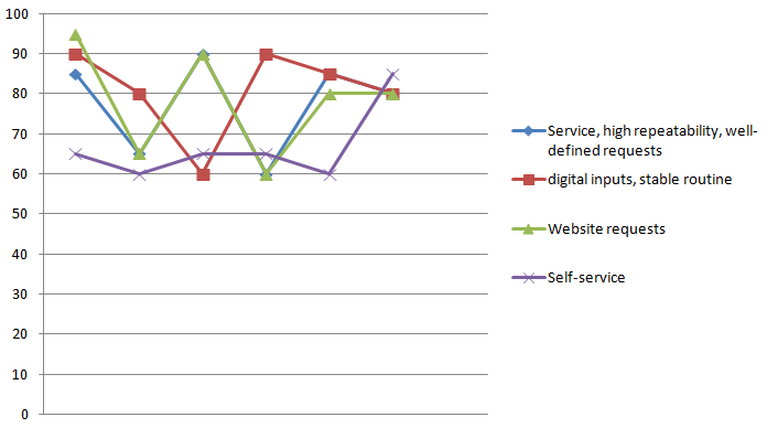
The chart (4Vs analysis) shows that services are declining, with high demands from customers. There is low repetition and high unit cost because some personnel are doing one job repetitively.
If this office can add technology, there will be high volume efficiency and the problem of low speed can be solved (Slack et al. 2013). Self-service are low volume in as much as this is not yet offered or not available. Demands are always high while service is low.
Five performance objectives for the Spatial Data Division
Quality is the foundation of any organisation. Quality of service and quality of the contents of the requested copies from the organisation’s database are significant in the transaction. Quality does not only mean conformance to customers’ requests but it also refers to the accuracy and reliability of the contents, the data and the maps (Beyond.UK: big five 2013).
Speed refers to ‘just being fast’, meaning, the time the requests are made to the time the ‘product’ (data and maps) is received by the customer. Speed is a prime concern of the division I am in, but speed has remained a goal in as much as change is difficult to introduce. Change has to deal with culture and tradition which are ingrained in the people. Political will is also a concern.
Dependability (trustworthiness) means the division is on time in the delivery of service, and customers keep coming back because they feel and know that their requests will be addressed to.
Flexibility in the Division’s operations means how it can answer to the requirements of the requests even if it requires too much work for the staff, or change the procedure to conform to the request.
Costs should be the lowest expense for the customers since this office is for public service, but the value of the service must be the highest.
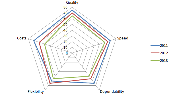
My personal survey for this office is that the Division’s performance has been declining for the three-year series, with respect to the five areas of performance objectives: ‘quality, speed, dependability, flexibility, and costs’.
However, quality has always been top priority as it got high percentage for the different periods. In summary, the division needs overhaul (changes and innovations to make service better) in order to improve the organisational performance and meet clients’ specifications and requests.
Analysis of the organisation’s current strategy
The current strategy needs innovations and changes. It is not clear when this method was started, although we can quickly surmise that this has been the case ever since the Spatial Data Division was established to answer to the needs of customers wanting spatial data, along with pictures and maps.
The database has been established and it is undeniable that it is very valuable to private individuals and business people. As always been stated here, culture and tradition influenced how systems work and are worked out.
The usual problem in our division is the long process and the delay in addressing the many requests from the customers. The process is repetitive and can be considered traditional and time-consuming, at risk of corruption and red tape. Our aim of speed of delivery has long been a goal but cannot be fully accomplished, because of lack of effective strategy and coordination, perhaps.
One of the problems is that the request form cannot be sent online. Online requests must be part of the processes to eliminate the long delay in the requests. Online negotiation is effective in providing speed of delivery of service.
This process can be enhanced through personal contact, i.e. the requesting party can conduct online and may have to appear to the officer concerned if need be. But important transactions can be conducted online. Even map requests and other information can be processed online, including payment.
First the customer goes to the customer service to fill up the request form and inform the office of the request’s rationale and the coverage area of the project or study. Then customer service sends this request to the Executive Director to register and send it to the division manager. Next, the division manager sends the request to the head of section, and the head of section assigns the task to an employee.
When he has done this, the employee should submit the validated request to the head of section again for approval, until the customer obtains the request, finally. The customer has to wait for the long tedious process. The request form passes through several persons before it reaches the personnel/section head responsible for validating the request.
The traditional method or process in our department is the old-fashioned way of delivering service to the people, because this has been the method we have been used to ever since I was employed by my department. There must be a way to deliver service without the unnecessary steps. This means we can shortcut the process without sacrificing the service quality and jeopardising organisational performance.
This current strategy reflects the norms and community behavior of the people (Matthews & Marzec 2012). In fact, it is part of our identity. We look at it as ingrained in our collective spirit, that is why it is difficult to modify but it is possible to improve.
The workflow demonstrates that there is quality, although there is lack of it, and there has been no change for the past several years. The process is an ‘old system’. The managers and the government need political will to institute reforms. A simple IT application can solve the problem.
IT application can simplify the process and total quality management can enhance effective and fast service delivery. The position of the two managers, the Executive Director and Division Director Manager, can be merged into one position. This practice demonstrates the ‘old system’.
An OM theory worthy of note is the theory of production, which refers to inputs and outputs. Inputs produce outputs but various inputs can be used to produce several outputs. Inputs can be analysed to describe how costs and outputs are met and how to maximise outputs. The theory of production helps determine the value of the input-output processes (Gupta & Boyd 2008).
The principle behind this theory involves the introduction of utilities, and utilities refer to labor which in essence is production. Consequently, production is the making of inputs into products or services.
In the context of the work area in question, the Spatial Data Division of the Abu Dhabi municipality, inputs do not necessarily mean tangible product but can be in the form of training, communication, and improvement or development of the website of the Abu Dhabi municipality, particularly the Spatial Data Division.
A detailed evaluative investigation using the application of Operations Management analysis tools, theory, concepts and principles
In the current process, the customer goes to the customer service to fill forms or requests. The process of validation is time-consuming. Before the request goes to the person responsible of validating or studying the request, the customer has to pass through the Executive Director and the Division Director Manager, then to the head of section, who passes the job to the head of unit.
An employee is assigned to check on the request, and the job is checked by Quality Assurance. The paper trail goes back to the head of section and finally to the customer service.
Additional inputs can produce good results or output for this division, which needs more coordination, communication and training of personnel in order to be effective, and to erase surplus, surplus in the form of personnel (who are doing nothing), or inadequate processes. The efficient use of time should be introduced in the division and not on accumulating more time before the customer gets his/her requests.
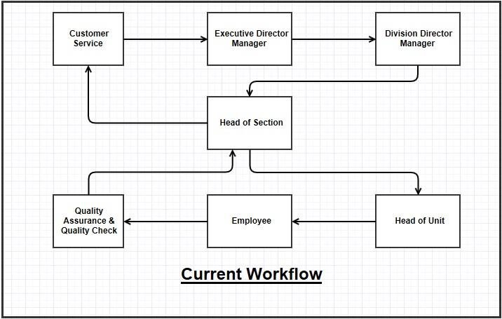
The current workflow demonstrates that the request has to pass through the office of the Executive Director Manager and the Division Director Manager before it goes to the Head of Section and the Head of Unit.
The steps involving the Executive Director and Division Director Manager can be eliminated, albeit temporary, because they still have to approve the request. But the approval should only be after the Head of Section and Head of Unit shall have done their part.
The division needs more thinking and planning to make the processes more effective. The application of TQM, the theory of constraints, and supply chain management enables an organisation to have systems thinking, integration of the various functions, and a more horizontal structure.
The operations manager will be able to introduce effective teams and participate in a collaborative decision making process with the team members (Gupta & Boyd 2008, p. 991). In manufacturing, they have this just-in-time and the application of teams. JIT and effective teams can be done in my division. Service will then become very effective.
Total quality management (TQM) is defined by Deming (as cited in Coman & Romen, 1995, p. 1404) as ‘conformance to requirements,’ which means an office has to comply with the customers’ requests per the customers’ specifications and at the soonest possible time. ‘Requirements’ means what the customers want.
Coman and Romen (1995, p. 1404) adds that the difference between meeting the needs of the customers and following requirements hinder effective service. One of the reasons for lack of effective service being offered by an organisation is tradition. Tradition becomes the law which should be followed to the letter, and so quality service is sacrificed.
Tradition is ingrained in the context of the Spatial Data Division and is very difficult to extract and heal. But, as they say, time will heal. It only needs for the managers and people behind the system, who are traditionalists themselves, to dispense with what they are used to doing routine and be acquainted with new principles and new technology, which are really indispensable in this age of globalisation and high-speed Internet.
The division also needs total quality. TQ is a philosophy based on principles, practices, and techniques, which should focus on customers, continuous improvement, and teamwork. Each of the principles has several practices or activities that may collect information from customers and analyse processes. Techniques are also provided in applying the practices.
Emphasis on customer needs, or customer focus, is the most important. The objective of satisfying customers is a basic requirement in total quality (TQ) and is a part of the organisation’s goal to design and provide products and services that meet customers’ needs (Dean & Bowen 1994, p. 394).
Another theory we can apply is system dynamics (Größler, Thun, & Milling 2008). System dynamics, which is further expounded at the conclusion of this paper, is a ‘structural theory’ which can be applied to the structural problem that causes service delays in the Spatial Data Division transactions.
This theory is based on a concept that ‘the structure of social systems is generally characterized by feedback loops, accumulation processes, and delays between cause and effect’ (Größler, Thun, & Milling, 2008, p. 374). System dynamics, which is comprised of conceptualisation and experiments, is integrated in many kinds of systems. It aims to design formal models and generate reaction for a certain period of time.
System dynamics theories result in real-world objects which offer ‘a lens to observe and to understand the represented system, but not a description of the total system or of all social systems’ (Größler, Thun, & Milling, 2008, p. 374).
Concepts in this theory are: feedback loops, accumulation processes, and delays between cause and effect. These concepts are all important in oprations management situations, most especially the Spatial Data Division. We can provide an example here.
If in this organisation, we have to apply improvement program we can use the feedback loop which influences worker motivation. Improvement program decreases employee motivation since there are fears that employees are made redundant with a successful program already introduced (Größler, Thun, & Milling, 2008).
Critical discussion and recommendations
Since this is a government agency or department, the effective solution is to shorten the process and the waiting time, and also avoid “red tape”. Red tape means unnecessary steps in the process of delivering service to the people who are the customers, and the process can also lead to corruption. This activity can be avoided by providing speed in the delivery of service, which is what the people in a democratic situation needs.
Shortening the process does not mean bypassing department or section heads. The effective way is for the customer to fill up the request form in the office of Section Head who will validate the request for a project. If the section head approves the request, then the process of approval can start right up to the Executive Director.
The process is reduced to two or three steps and may just take up to one day or a few hours to complete. If more studies are needed for the project, it may only take a short time before the request can be approved or denied. The website should be developed and improved, enhance the features by providing an interactive communication between the department and the customers.
The potential costs in not solving the problem are waste of time and resources involving taxpayers’ money. The cost of building a database such as this division is no easy feat. It involved government resources. Much more of these resources will be lost if changes are not provided in the soonest possible time.
The office and the government as a whole will also lose its credibility and trust from the people. Some inferences of spatial data are still unknown and are in the process of verification (Fotheringham & Brunsdon 2004). If these are not verified and investigated, they might forever be lost.
Another practical solution to the problem of the Spatial Data Division of Abu Dhabi municipality is the application of Systems Dynamics. This is a method to show, replicate, and reproduce active systems, like our organisation which is just a division or department of the Abu Dhabi municipality.
Brunswick (1956 as cited in Größler, Thun, & Milling, 2008, p. 374) formulated the ‘lens theory’ which states that ‘theories are like lenses that influence the perception of phenomena’.
System dynamics also refers to articles and journals with empirical evidence about the relationships of factors in social systems. The background for a certain system influences the future development of that system, which is characterised by time delays (Größler, Thun, & Milling, 2008).
The ‘product’ in applying system dynamics theory and method to the parameters of the Spatial Data Division are, still, theories but they represent linkages between the objects as they become part of the real world.
This means the result is improvement in service and the elimination of time delays in providing service. Good systems dynamics models are considered authentic representations of specific problems, for example, the improvement in the processes inside the Spatial Data Division.
The application of Information Technology (Geographic Information Systems) should be perfected to ensure and improve quality service. GIS provides a database for keeping, management, and recovery of higher volume of geographical statistics (Alkobaisi et al. 2012, p. 30). GIS is composed of layers or elements and the subject of the information data, for example roads and lands.
Coordinates provide the relation of the layers, so that when layers are in the same coordinates, a relationship is established. Yu and Peuquet (2009) argued that ‘object, field, and time’ are three basic elements for representation of surveyed environmental dynamics. The new GIS should be more than the current data-centred paradigm to detect geographic representation in a knowledge rich period.
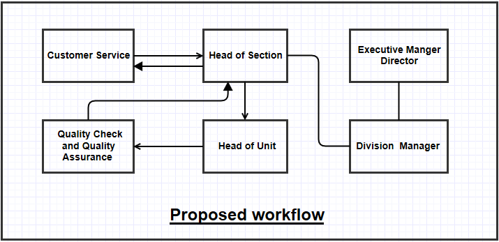
In this proposed workflow, time and process are shortened. The customer who signs the request form at the customer service is directed to the head of section, with the Executive Manager Director and Division Manager informed and their opinion being sought.
At the same time, the paper trail goes to the head of unit who passes this to quality check and quality assurance and then back to the customer service. The process is already shortened.
The division needs to work as a team, or formulate teams. In the current workflow, the system seems not working because the personnel are not members of a team. Work teams save time and allow the process to work for the customers’ needs and conform to their specifications.
Communication is enhanced in the team. Effective communication will not allow flaws in the system, but it allows the system to flow for the team members to work for the success of the organisation and the customers.
The Spatial Data Division personnel and managers need motivation through training and development. The team members have to experience continuous training to enhance their skill and capability.
Training, capability building and motivation will harness their full potential. The managers and the members working as a team will erase the ‘boss and subordinate’ mindset and make this department successful in serving the people of Abu Dhabi and beyond.
References
Alkobaisi, S, Bai, W, Vojtӗchovský, P, & Narayanappa, S 2012, ‘An interactive framework for spatial joins: a statistical approach to data analysis in GIS’, Geoinformatica, vol. 16, pp. 329-355. Web.
Beyond.UK: big five. 2013. Web.
Coman, A. & Ronen, B. 1995, ‘Information technology in operations management: a theory-of-constraints approach’, International Journal of Production Research, vol. 33, no. 5, pp. 1403-1415, via EBSCOHOST database.
Dean, J & Bowen, D 1994, ‘Management theory and total quality: improving research and practice through theory development’, Academy of Management Review, vol. 19, no. 3, via ProQuest Research Library.
Department of Municipal Affairs: Abu Dhabi city municipality 2014. Web.
Fotheringham, A. & Brunsdon, C 2004, ‘Some thoughts on inference in the analysis of spatial data’, Internal Journal of Geographical Information Science, vol. 18, no. 5, pp. 447-457, via EBSCOHOST database.
Größler, A, Thun, J, & Milling, P 2008, ‘System dynamics as a structural theory in operations management’, Production and Operations Management, vol. 17, no. 3, pp. 373-384, via EBSCOHOST database.
Gupta, M & Boyd, L 2008, ‘Theory of constraints: a theory for operations management’, International Journal of Operations & Production Management, vol. 28, no. 10, pp. 991-1012, via EBSCOHOST database.
Matthews, R & Marzec, P 2012, ‘Social capital, a theory for operations management: a systematic review of the evidence’, International Journal of Production Research, vol. 50, no. 24, pp. 7081-7099, via EBSCOHOST database.
Slack, N, Brandon-Jones, A, Johnston, R, & Betts, A 2013, Operations and process management: principles and practice for strategic impact (3rd edn), Pearson Ltd., London.
Yu, C & Peuquet, D 2009, ‘A geo agent-based framework for knowledge-oriented representation: embracing social rules in GIS’, International Journal of Geographical Information Science, vol. 23, no. 7, pp. 923-960, via EBSCOHOST database.